交通(ニュース) アーカイブ
- 2013年10月29日 Tioga Rd 雪のため閉鎖
- 2013年08月28日 RIM FIRE
- 2012年11月22日 タイオガロード、グレイシャーポイントロードはクローズ
- 2012年06月19日 ヨセミテ国立公園の交通集中予報
- 2012年03月09日 Big Oak Flat Road再開通
- 2012年02月18日 Big Oak Flat Road (Highway 120)再び閉鎖
- 2012年01月28日 120号線(Big Oak Flat Road)が再開通
- 2012年01月24日 SFクロニコル紙記事
- 2012年01月24日 120号線/Big Oak Flat Roadが通行止
- 2012年01月10日 Yosemite like you’ve never seen it
- 2011年12月03日 タイオガロード(120号線)状況
- 2011年11月17日 通行再開
- 2011年06月17日 タイオガロード開通は18日(土)午前8時
- 2011年06月16日 Tioga Road除雪
- 2011年05月23日 Tioga Pass情報(Lee Vining側)
- 2011年04月18日 マリポサグローブへの道路オープン
- 2010年11月10日 Tioga Road、Glacier Point Roadはクローズ
- 2010年06月04日 Tioga Road
- 2010年03月26日 Mariposa Grove Road開通
- 2009年11月16日 タイオガロードは雪のためクローズ
- 2009年11月06日 The Hetch Hetchy Road
- 2009年10月16日 Tioga Road Reopen
- 2009年10月14日 Tioga Road、Glacier Point Road一時通行止
- 2009年10月14日 Tioga Road閉鎖
- 2009年08月31日 Tioga Roadも通行制限
- 2009年08月28日 Big Oak Flat road沿線で山火事
- 2009年05月15日 CA108 (Sonora Pass) Open
- 2009年05月14日 Bicycles on Tioga Road
- 2009年05月08日 Tioga Road除雪状況 (5/6)
- 2009年05月07日 Valley内交通規制解除
- 2009年05月06日 GP Road開通
- 2008年08月22日 ヘッチ・ヘッチーロードの通行時間変更(9/2〜
- 2008年08月16日 山火事影響による道路通行・電力供給は回復しています
- 2008年07月30日 CA140号線情報
- 2008年06月17日 YARTSは夏ダイヤへ
- 2008年04月11日 ヴァレー・シャトルバス運行情報
- 2007年12月09日 Tioga & Glaciar Point Road 雪でクローズ
- 2007年10月30日 クレーンフラットのガソリンスタンド再オープンさらに延期
- 2007年10月27日 YARTSバス時刻変更
- 2007年09月01日 クレーンフラットのガソリンスタンド一時休止
- 2007年08月29日 Slow Down!
- 2007年08月29日 Big Oak Flat Road 修理工事
- 2007年05月10日 タイオガロード開通 (May 11)
- 2007年05月06日 グレイシャーポイント・ロード 土曜開通
- 2007年05月03日 Tioga Road除雪状況 (Final Stage)
- 2007年05月02日 グレイシャーポイント・ロード状況
- 2007年04月30日 ハイウェイ事故(29日)
- 2007年04月27日 CA108 OPEN
- 2007年04月21日 108号除雪、Sonora Passの上り口まで完了
- 2007年04月21日 GP Road除雪 残り2マイル
- 2007年04月19日 除雪作業情報(タイオガ&グレイシャーポイント)
- 2007年04月09日 108号除雪開始
- 2006年12月06日 マリポサグローブ道路冬季閉鎖
- 2006年11月29日 Tioga Road & Glacier Point Road 冬季閉鎖
- 2006年11月28日 Tioga Road
- 2006年11月06日 ヨセミテ渓谷南側道路の閉鎖
- 2006年11月02日 シーズン終了
- 2006年10月11日 Tioga Road雪で閉鎖->開通
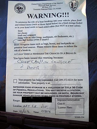
- 2006年10月09日 警告書
- 2006年09月02日 140号 常時開通
- 2006年08月19日 140号 再開通
- 2006年08月17日 140号:2本目の橋架かる
- 2006年07月28日 140号:仮設の橋がほぼ完成、開通7月31日
- 2006年07月03日 El Capitan Shuttle Bus
- 2006年06月28日 YARTSバス時刻表変更
- 2006年06月18日 Tioga Road開通 : June 17 2006
- 2006年06月15日 Tioga Road 17日開通予定!
- 2006年06月10日 140号崖崩れ:Web
- 2006年05月31日 140号: 長期閉鎖
- 2006年05月30日 グレイシャーポイントロード開通
- 2006年05月26日 108号開通
- 2006年05月26日 140号開通=>閉鎖
- 2006年05月22日 グレイシャーポイントロード状況
- 2006年05月22日 140号閉鎖は5月29日まで?
- 2006年05月14日 YARTSバス運行情報
- 2006年05月05日 140号線開通->閉鎖->開通
- 2005年11月26日 Tioga Road閉鎖
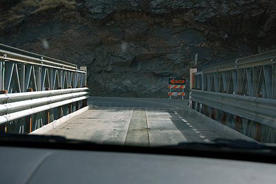
- 2005年11月21日 白いSUVに要注意
- 2005年11月17日 チェーン規制のサイン
- 2005年10月31日 Tioga Road
- 2005年10月01日 クリーン・バス・リーダー
- 2005年08月09日 エルキャピタンへの実験シャトル
- 2005年08月05日 YARTSバス120号東線が運行延長
- 2005年07月02日 【注意】Holiday weekendの交通
- 2005年06月29日 YARTSバス(120号東線)の運行
- 2005年06月17日 タイオガロード状況
- 2005年06月14日 ハイブリッド・シャトルバス
- 2005年06月11日 ヴァレー内交通規制
- 2005年05月27日 マリポサグローブ
- 2005年05月23日 除雪状況(続)
- 2005年05月07日 Mariposa Grove Roadオープン!
- 2005年05月03日 GAS price
- 2005年04月22日 140号線の通行規制
- 2005年04月15日 除雪作業/タイオガロード・グレイシャーポイントロード
- 2005年03月21日 ハイブリッド・シャトルバス(続)
- 2005年03月09日 ハイブリッド・シャトルバス
- 2005年01月16日 120号
- 2005年01月10日 Yosemite 近況
- 2004年12月25日 Northside Driveの通行規制
- 2004年12月12日 120号の状況
- 2004年10月29日 Tioga Road & Glacier Road
- 2004年10月24日 120号道路工事
- 2004年10月20日 雪です
- 2004年07月16日 グレイシャーポイントロード閉鎖
- 2004年06月19日 スピード違反に御注意
- 2004年06月14日 GAS price
- 2004年05月27日 クルマ通行規制
- 2004年05月20日 ガソリン高騰…
- 2004年05月18日 冬季道路閉鎖解除・残雪状況
- 2004年05月04日 Tioga Road の状況
- 2004年05月01日 シエラの峠道 開通予定日
- 2004年04月30日 タイオガロード除雪状況(4/29)
- 2004年04月24日 タイオガロード除雪状況(4/21)
- 2004年04月22日 ラスベガス発ヨセミテ
- 2004年04月19日 タイオガロード除雪状況(4/17)
- 2004年04月17日 タイオガロード除雪作業開始!
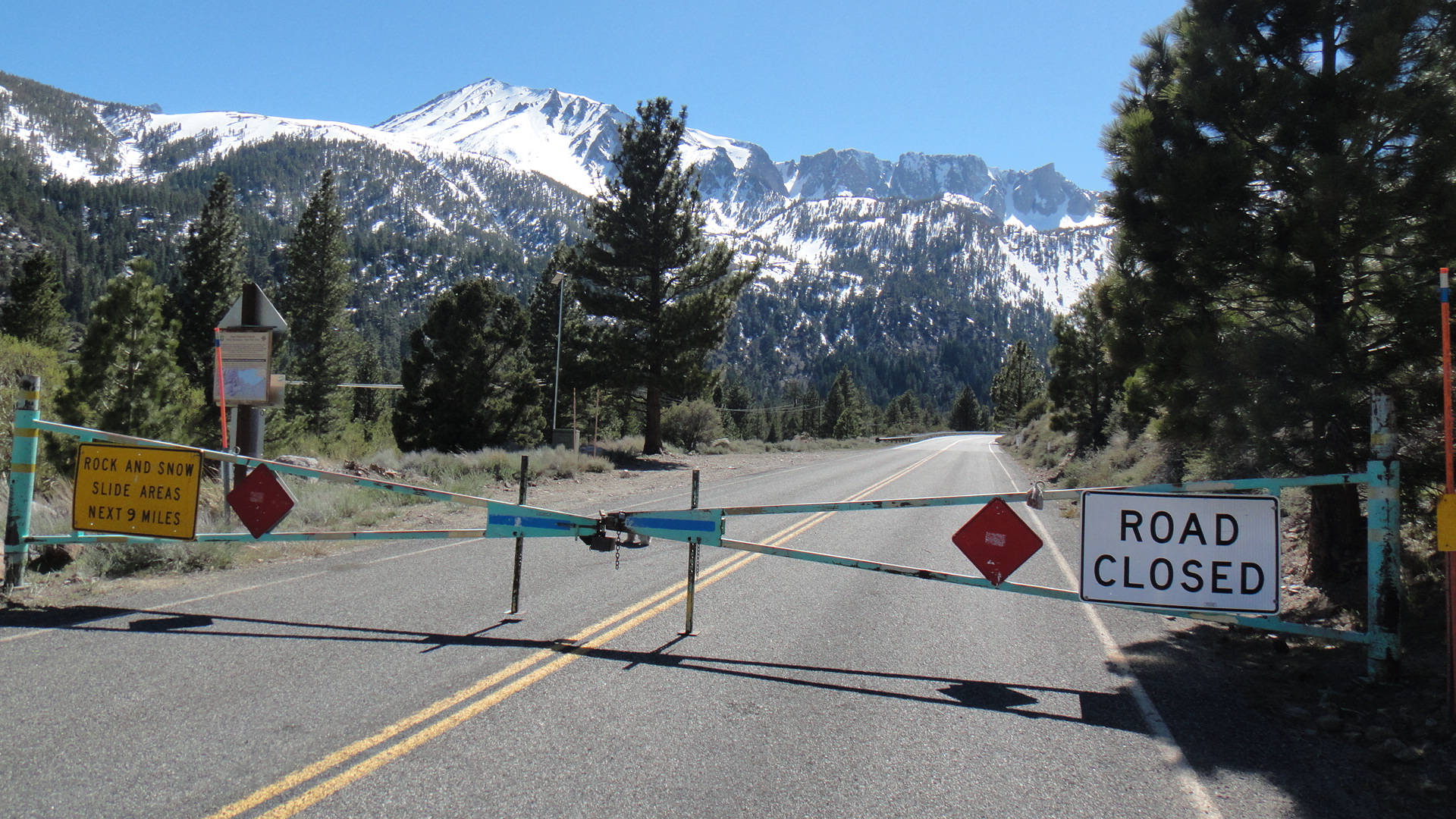
2013年10月29日
Tioga Rd 雪のため閉鎖
昨晩から天気が悪化、雪のためTioga Rd(120), 108, 4 などは閉鎖中です。
積雪の状態、今後の天気しだいでは再度開通する可能性もあります。
URGENT - WINTER WEATHER MESSAGE
NATIONAL WEATHER SERVICE HANFORD CA
1204 PM PDT MON OCT 28 2013
CAZ096-290600-
/O.CON.KHNX.WW.Y.0008.000000T0000Z-131029T0600Z/
SIERRA NEVADA FROM YOSEMITE TO KINGS CANYON-
1204 PM PDT MON OCT 28 2013
...WINTER WEATHER ADVISORY REMAINS IN EFFECT UNTIL 11 PM PDT THIS
EVENING ABOVE 5000 FEET...
A WINTER WEATHER ADVISORY ABOVE 5000 FEET REMAINS IN EFFECT UNTIL
11 PM PDT THIS EVENING FOR THE SOUTHERN SIERRA NEVADA FROM
YOSEMITE TO KINGS CANYON.
* SNOW ACCUMULATIONS OF 3 TO 6 INCHES.
* ELEVATION: ABOVE 5000 FEET.
* TIMING: SNOW CONTINUING THROUGH THIS EVENING.
* LOCATIONS INCLUDE: YOSEMITE NATIONAL PARK...SHAVER LAKE
* IMPACTS: TRAVEL DIFFICULTIES WITH CHAINS REQUIRED AND POSSIBLE ROAD
CLOSURES. SNOW WILL RESULT IN SLIPPERY ROADS AND POOR
VISIBILITIES.
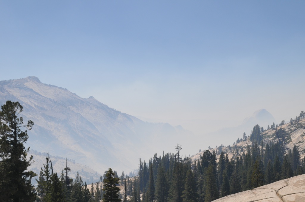
2013年08月28日
RIM FIRE
にしむら@ヨセミテ大好き!です。
ただいまTuolume Meadowsに滞在中です。
Toshiさんから投稿のあったRIM FIREですが、ここからも西方面に煙が見えており、かなり大規模です。
120号線は閉鎖中で、今回は140号を使ってヨセミテヴァレーを経由して来ました。
ヨセミテヴァレーには煙は入っておらず、視界はクリアーでした。
と、かいているうちに
Beginning at noon on Wednesday, August 28, the Tioga Road (Highway 120 through the park) is closed from Crane Flat to Yosemite Creek. The only access to the Tuolumne Meadows area is via Highway 120 from near Lee Vining.
明日から、Tioga roadがクローズです。
Tuolmune Meadowsから120号で帰れません!
2012年11月22日
2012年06月19日
2012年03月09日
2012年02月18日
Big Oak Flat Road (Highway 120)再び閉鎖
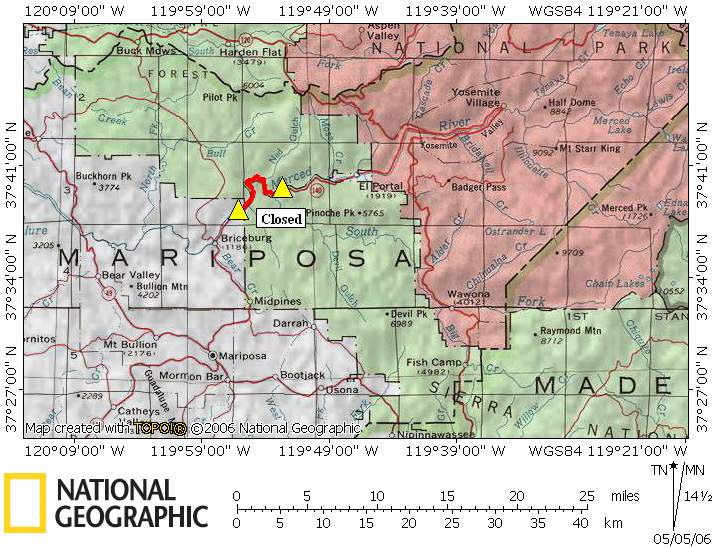
1/22に起きた崖崩れによってBig Oak Flat Road (Highway 120)がダメージを受けていますが、2/29から本格復旧工事を始めるため、4月上旬まで約6週間完全通行止めとなります。
工事中は120号を使ってヨセミテヴァレーにアクセスすることができなくなります。
140号でEl Portal経由、41号を使ってOakhurst/Wawona経由で入ることになりますので、ご注意ください。
詳細記事は
http://www.nps.gov/yose/parknews/bofroadrepairclosure212.htm
2012年01月28日
120号線(Big Oak Flat Road)が再開通
崖崩れで通行止めになっていた120号線(Big Oak Flat Road)が今朝早くも再開通。仕事の速さに拍手!
http://www.nps.gov/yose/parknews/bofreopen.htm
2012年01月24日
SFクロニコル紙記事
SFクロニコル紙も120号線通行止めを伝えています。
Rockfall closes Highway 120 into Yosemite
記事によると、復旧までには2週間〜2ヶ月間かかると報じられています。
120号線/Big Oak Flat Roadが通行止
23日夕刻に崖崩れが発生し、120号線/Big Oak Flat Roadが通行止になっています。
Forestaと120/140号線合流地点の間です。
復旧するまでヨセミテヴァレー入りには120号線は使えませんのでご注意ください。
NPSの情報
http://www.nps.gov/yose/parknews/bofrdclosed12.htm
公式facebookページには写真が掲載されていました。
2012年01月10日
Yosemite like you’ve never seen it
サンフランシスコ・クロニコル紙に「Yosemite like you’ve never seen it」という記事が出ています。今年の冬はほんとに雪が少なくて、例年11月には冬季閉鎖になるタイオガロードが未だに通行可能です。
2011年12月03日
タイオガロード(120号線)状況
雪のためClane Flatから西5マイル地点で通行不可になっています。
This highway information is the latest reported as of Friday, December 2, 2011 at 16:30 .
SR 120
[IN THE CENTRAL CALIFORNIA AREA & SIERRA NEVADA]
IS CLOSED FROM CRANE FLAT TO 5 MI WEST OF THE JCT OF US 395
/TIOGA PASS/ (TUOLUMNE, MONO CO) - DUE TO SNOW - MOTORISTS ARE
ADVISED TO USE AN ALTERNATE ROUTE
[YOSEMITE NAT'L PARK]
FOR YOSEMITE NAT'L PARK ROAD INFORMATION CALL 209-372-0200
2011年11月17日
2011年06月17日
タイオガロード開通は18日(土)午前8時
タイオガロード開通は18日(土)午前8時とNPSのサイトに掲載されました。
http://www.nps.gov/yose/parknews/tiogaopens611.htm
2011年06月16日
Tioga Road除雪
The Tioga Road will open on Saturday, June 18, 2011, at 8 am. There will be several no-stopping zones and visitors should be aware that hiking opportunities are extremely limited due to snow and dangerous creek crossings. No services will be available along the road.
http://www.nps.gov/yose/planyourvisit/tioga.htm
http://www.nps.gov/yose/planyourvisit/tiogaopen.htm
Beginning Friday, June 10, the Tioga Road will be open to bicycles from Crane Flat to Olmsted Point. There will be no access beyond Olmsted Point due to the avalanche zone just east of Olmsted Point. From the east, the road is open to bikes from US 395 to the west end of Tuolumne Meadows. It will be signed accordingly. Please be on the lookout for debris falling into the road and administrative vehicles travelling back and forth.
全線をとりあえず除雪したようですが、開通には最低でも2週間はかかりそうですね。
下のリンクに新しい写真が入っています。
The Tioga Road has been partly plowed for its entire length. Now, road crews are working to remove snow from the entire width of the road and plow turnouts and side roads. In addition, road crews will be removing rockslides and redirecting snowmelt across the road to reduce icy road conditions. Finally, Olmsted Point is still unsafe due to avalanche danger.
The Tioga Road is now open to bicycles from Crane Flat to Yosemite Creek Bridge. Please watch out for debris on the road and road crew traffic. If conditions allow, we will extend the bicycle zone farther east prior to the opening.
The Glacier Point Road opened on Friday, May 27, 2011.
The Tioga Road is now open to bicycles from Crane Flat to Yosemite Creek Bridge. Please watch out for debris on the road and road crew traffic. If conditions allow, we will extend the bicycle zone farther east prior to the opening.
Olmsted Pt.の斜面ははすでに越えています。
Last Update: May 26, 2011
Tioga Road: Crews are working east from Olmsted Point. Mono County & Mammoth Mountain crews are working between Marmot Dome and Spring hill.
The Glacier Point Road opens at noon on Friday, May 26, 2011.
Last Update: May 25, 2011
Tioga Road: Crews are working near Olmsted Point.
Additionally, as of May 20, Mono County Public Works and Mammoth Mountain crews have plowed to 3.8 miles from Tioga Pass. Mammoth Mountain is using snowcats to expedite the process.
Last Update: May 23, 2011
Tioga Road: Yesterday, crews plowed from May Lake to May Lake Pit. Snow depth is 15 feet or deeper.
Additionally, as of May 20, Mono County Public Works and Mammoth Mountain crews have plowed to 3.8 miles from Tioga Pass. Mammoth Mountain is using snowcats to expedite the process.
Glacier Point Road: The road has been plowed, but additional work is required before the road can open. There is no estimated opening date. (The road usually opens by the end of May.)
Last Update: May 20, 2011
Tioga Road: Yesterday, crews plowed to Porcupine Creek Trailhead (two miles from previous point).
Additionally, Mono County Public Works and Mammoth Mountain crews have begun plowing from the east side and are now at Mono/Parker Pass Trailhead.
Glacier Point Road: The road has been plowed, but additional work is required before the road can open. (See photos below the map.) There is no estimated opening date. (The road usually opens by the end of May.)
Last Update: May 19, 2011
Tioga Road: Yesterday, crews plowed the Big Oak Flat Road due to new snowfall, plowed 18-20 inches of new snow on the Tioga Road, then plowed 0.4 miles from previous point (now at Porcupine Summit). Snow depth is 11 feet.
Additionally, Mono County Public Works and Mammoth Mountain crews have begun plowing from the east side and are now at Mono/Parker Pass Trailhead.
Glacier Point Road: No update. Last update: Crews worked on widening along the Glacier Point Road and clearing in the parking lot. Snow depth in the lower lot is 3 to 4 feet and the upper lot is 4 to 7 feet. Next week, crews will begin plowing the trail between the parking lot and the point.
Last Update: May 17, 2011
Tioga Road: Yesterday, crews plowed 0.8 miles and went through an avalanche zone at Yosemite Creek hill.
Glacier Point Road: No update. Last update: Crews worked on widening along the Glacier Point Road and clearing in the parking lot. Snow depth in the lower lot is 3 to 4 feet and the upper lot is 4 to 7 feet. Next week, crews will begin plowing the trail between the parking lot and the point.
Last Update: May 16, 2011
Tioga Road: Yesterday, crews started at Yosemite Creek and ended at an avalanche zone, plowing 1.6 miles. Crews will attempt to go through the avalanche zone today, conditions permitting.
Glacier Point Road: No update. Last update: Crews worked on widening along the Glacier Point Road and clearing in the parking lot. Snow depth in the lower lot is 3 to 4 feet and the upper lot is 4 to 7 feet. Next week, crews will begin plowing the trail between the parking lot and the point.
Last Update: May 13, 2011
Tioga Road: No update. Previous update: Rotary plows have reached the Siesta Lake area just past the 8,000 foot elevation mark. Snow depths average 10 feet in depth. Charcoal has been spread over Olmsted Point to aid the melting of the snow above the road. Crews will work Monday through Saturday.
Glacier Point Road: Crews worked on widening along the Glacier Point Road and clearing in the parking lot. Snow depth in the lower lot is 3 to 4 feet and the upper lot is 4 to 7 feet. Next week, crews will begin plowing the trail between the parking lot and the point.
やっとSiesta Lakeの近くに到達しました。雪が一番深い地帯(White Wolfの東側)にはまだいたっていません。
Last Update: May 9, 2011
Tioga Road: Rotary plows have reached the Siesta Lake area just past the 8,000 foot elevation mark. Snow depths average 10 feet in depth. Charcoal has been spread over Olmsted Point to aid the melting of the snow above the road. Crews will work Monday through Saturday.
Glacier Point Road: Dozers have plowed off enough snow that the rotary blowers are to Washburn Point. Work will continue Monday through Thursday working down through the switchbacks to the parking lot. Average snow depth is still eight feet.
Mariposa Grove: The road is open; all weight restrictions have been removed.
2011年05月23日
Tioga Pass情報(Lee Vining側)
タイオガパスの開通情報がウェブサイトによってごっちゃになっていて、開いているはずと思い込んでやってくる観光客の人が多くなってきたので、正しい情報をと思いまして。。。
モービルから4マイルほどの下ゲートですが、ここも開いてません。
モノカウンティが行う除雪は公園内まで入っていますが、雪解けによる落石や雪崩の危険性が高いので、一般には開けられないというのが理由だそうです。
多分来週中は天気が良さそうなので、ここ1週間で下のゲートは開きそうな気配です。
マンモスマウンテンのスキー場がスノーキャットを送り込んで除雪頑張ってるそうなので、6月も2週目までには開くだろうというのが予想です。
ゲートからは徒歩やバイクなら歩いてパスを上がれます。車がこないので最高です!!
通常ソノラパスが89の次に開きます。R4も間もなく開くでしょう。
ソノラはとても雪の多い年でも、メモリアルウィークエンド前後には開く事が多いです。今年もその気配。。。
ちなみにリーバイニングからソノラパスを通ってヨセミテバレーへは、6時間くらいでしょうか。
BBSの欄に書き込みがあったハッシーさんに返信させて頂きましたけど、かなり遅いので見られないでしょうねぇ。。
下ゲートが開いたら公園入り口までいけますので、そしたらまたご連絡しますね!!
2011年04月18日
マリポサグローブへの道路オープン
15日からマリポサグローブへの道路がオープンしています。春のシーズンが始まりましたね。
Mariposa Grove Road to Open in Yosemite National Park (2011)
2010年11月10日
Tioga Road、Glacier Point Roadはクローズ
Tioga Road、Glacier Point Roadは冬季通行止に入りました。
http://www.nps.gov/yose/planyourvisit/conditions.htm
2010年06月04日
Tioga Road
土曜朝に開通予定です。
The Tioga Road will open on Saturday, June 5, 2010 at 8 am. No camping, lodging, or other services will be available along the road.
Note: Sonora Pass (Highway 108) and Ebbetts Pass (Highway 4), north of Yosemite, opened for the season on May 28.
Tioga Road:
The Tioga Road will not be open for Memorial Day weekend; there is no estimated opening date.
Bicyclists may travel on the Tioga Road from Crane Flat to Olmsted Point (but not to Tuolumne Meadows).
Note: Sonora Pass (Highway 108) and Ebbetts Pass (Highway 4), north of Yosemite, opened for the season on May 28.
May 17, 2010
Glacier Point Road:
Crew is now working back from Glacier Point to widen and clean roadway. Crews are also sweeping and patching potholes. Average snow depth is 4 feet. Plowing operations will continue today.
Contractor is working on the road from Chinquapin to Badger Pass.
Note: If the Glacier Point Road opens for the season prior to May 28, it will be open Saturdays and Sundays only through May 27 (plus Friday, May 21) due to road work. Delays may occur after May 28, but the road will be open seven days per week.
Tioga Road:
Plows have reached Tioga Pass and will now be working on widening the road. Plowing continues Monday - Saturday. Average Snow Depth is 4 to 6 feet. Plowing operation will continue today.
May 14, 2010
Glacier Point Road:
Crew is now working back from Glacier Point to widen and clean roadway. Crews are also sweeping and patching potholes. Average Snow Depth is 4 feet Plowing operations will continue today.
Contractor is working on the road from Chinquapin to Badger Pass.
Note: If the Glacier Point Road opens for the season prior to May 28, it will be open Saturdays and Sundays only through May 27 (plus Friday, May 21) due to road work. Delays may occur after May 28, but the road will be open seven days per week.
Tioga Road:
Crew currently past Road Camp: 41.4 plowed miles of 42 miles. Plowing continues Monday - Saturday. Average Snow Depth is 4 to 6 feet. Plowing operation will continue today.
May 13, 2010
Glacier Point Road:
Crew is now working back from Glacier Point to widen and clean roadway. Crews are also sweeping and patching Potholes. Average Snow Depth is 4 feet Plowing operations will continue today.
Contractor is working on the road from Chinquapin to Badger Pass.
Note: If the Glacier Point Road opens for the season prior to May 28, it will be open Saturdays and Sundays only through May 27 (plus Friday, May 21) due to road work. Delays may occur after May 28, but the road will be open seven days per week.
Tioga Road:
Crew currently at Visitor Center: 38.6 plowed miles of 42 miles. Working on widening the road. Plowing continues Monday - Saturday. Average Snow Depth is 4 to 6 feet. Plowing operation will continue today.
May 12, 2010
Glacier Point Road:
Crew had to plow and sand from new snow accumulation and is now working back from Glacier Point to widen and clean roadway. Crews are also Sweeping and Patching Potholes. Average Snow Depth is 4 feet Plowing operations will continue today.
Contractor is working on the road from Chinquapin to Badger Pass.
Note: If the Glacier Point Road opens for the season prior to May 28, it will be open Saturdays and Sundays only through May 27 (plus Friday, May 21) due to road work. Delays may occur after May 28, but the road will be open seven days per week.
Tioga Road:
Crew currently at Visitor Center: 38.6 plowed miles of 42 miles. Plowing continues Monday - Saturday. Average Snow Depth is 4 to 6 feet. Plowing operation will continue today.
May 11, 2010
Glacier Point Road:
Crew is working back from Glacier Point to widen and Clean roadway. Crews are also sweeping and patching potholes. Contractor is working on road from Chinquapin to Badger Pass. Average snow depth is 4 feet. Plowing operations will continue today.
Note: If the Glacier Point Road opens for the season prior to May 28, it will be open Saturdays and Sundays only through May 27 (plus Friday, May 21) due to road work. Delays may occur after May 28, but the road will be open seven days per week.
Tioga Road:
Crew currently at Pothole Dome: 37 plowed miles of 42 miles. Plowing continues Monday - Saturday. Average Snow Depth is 4 to 6 feet Plowing operation will continue today.
May 10, 2010
Glacier Point Road:
Crew is working back from Glacier Point to widen and clean roadway. Average Snow Depth is 4 feet. Contractor is working on road from Chinquapin to Badger Pass. Plowing operations will continue today.
Note: If the Glacier Point Road opens for the season prior to May 28, it will be open Saturdays and Sundays only through May 27 (plus Friday, May 21) due to road work. Delays may occur after May 28, but the road will be open seven days per week.
Tioga Road:
Crew is currently at Spring Hill avalanche zone, 31.7 miles from Crane Flat. Plowing continues Monday-Saturday. Average snow depth is 4 to 6 feet. Plowing operation continues today.
May 6, 2010
Glacier Point Road:
Crew is working back from Glacier Point to widen and clean roadway. Average Snow Depth is 5 to 6 feet. Plowing operations will continue today.
Note: If the Glacier Point Road opens for the season prior to May 28, it will be open Saturdays and Sundays only through May 27 (plus Friday, May 21) due to road work. Delays may occur after May 28, but the road will be open seven days per week.
Tioga Road:
Ending location: Olmsted Point parking
Average snow depth: 8 to 9 feet
Plowing operations will continue today.
May 5, 2010
Glacier Point Road:
End location is Glacier Point.
Average snow depth is 5 to 6 feet.
Plowing operations will continue today
Note: If the Glacier Point Road opens for the season prior to May 28, it will be open Saturdays and Sundays only through May 27 (plus Friday, May 21) due to road work. No additional road work is expected after May 28.
Tioga Road:
Ending location: May Lake Pit, 26.6 miles from Crane Flat
Average snow depth: 8 to 9 feet
Plowing operations will continue today.
April 29, 2010
Glacier Point Road:
End location is Summit Meadow.
Plowing through 8 and 9 feet of snow.
Plowing operations will continue today
Note: Once the Glacier Point Road opens for the season, it will be open Saturdays and Sundays only through May 27. (It will also be open on May 21.) Beginning May 28, the road will be open every day until fall closing.
Tioga Road:
Tioga plowing operations were halted due to wet slab avalanche activity at the South Fork avalanche zone. With freezing temperatures forecast, plowing ops are expected to resume today.
April 27, 2010 update
Glacier Point Road:
Start: 1 mile east of Badger Pass
End: 1.8 miles east of Badger Pass
Average snow depth: 9 feet and very wet/heavy
Note: Once the Glacier Point Road opens for the season, it will be open Saturdays and Sundays only until May 27. (It will also be open on May 21.) After May 27, the road will be open every day until fall closing.
Tioga Road:
Start: 8,000 ft mark
End: White Wolf Junction (11.9 miles from Crane Flat)
Average snow depth: 7 feet
April 26, 2010 update
Tioga Road:
Start: 9 miles from Crane Flat
End: 12 miles from Crane Flat (8,000 ft mark)
Miles plowed: 3 miles
Average snow depth: Not specified
Glacier Point Road:
Start: Summit Meadow
End: Not specified
Miles plowed: Not specified
Average snow depth: 8-9 feet
Note: Once the Glacier Point Road opens for the season, it will be open Saturdays and Sundays only until May 27. (It will also be open on May 21.) After May 27, the road will be open every day until fall closing.
April 20, 2010 update
Glacier Point Road:
Start: 0.7 miles from Badger Pass
End: 1 miles from Badger Pass
Miles plowed: 0.3 miles (from Badger Pass)
Average snow depth: 7 feet
Note: Once the Glacier Point Road opens for the season, it will be open Saturdays and Sundays only until May 27. (It will also be open on May 21.) After May 27, the road will be open every day until fall closing.
Tioga Road:
Start: Crane Flat
End: Walker Party
Miles plowed: 4 miles
Average snow depth: 6 feet
2010年03月26日
Mariposa Grove Road開通
マリポサグルーブロードが3月26日朝から開通します。
売店やトラムツアーの営業はまだです。なお残雪や凍結箇所があり通行には十分注意してください。
----
Mariposa Grove Road to Open in Yosemite National Park
Date: March 25, 2010
The Mariposa Grove Road in Yosemite National Park will open for the season tomorrow, March 26, 2010 at 9:00 a.m. The road provides visitor access to the Mariposa Grove of Big Trees, the largest grove of Giant Sequoia in Yosemite National Park. The road is located near the park’s South Entrance, on Highway 41.
Commercial services within the Mariposa Grove will open later in the season. Additionally, tram tours will begin later in the season.
There is currently a 6,000 lb. weight restriction on the road. Visitors are urged to drive with caution as snow and ice may still be present on the road. The Mariposa Grove Road may intermittently close due to weather conditions.
2009年11月16日
タイオガロードは雪のためクローズ
カリフォルニア・ハイウェイ情報によれば、120号線タイオガロードは雪のためクローズとなっています。
SR 120
[IN THE CENTRAL CALIFORNIA AREA]
IS CLOSED FROM CRANE FLAT TO 5 MI WEST OF THE JCT OF US 395 /TIOGA PASS/
(TUOLUMNE, MONO CO) - DUE TO SNOW - MOTORISTS ARE ADVISED TO USE AN ALTERNATE
ROUTE
[YOSEMITE NAT'L PARK]
FOR YOSEMITE NAT'L PARK ROAD INFORMATION CALL 209-372-0200
2009年11月06日
The Hetch Hetchy Road
ヘッチ・ヘッチー・ロードの通行(入場)がオフシーズン時間帯となり8:00am から 5:00pmの間に制限されています。
The Hetch Hetchy Road day use hours are 8:00am to 5:pm (C Flores 11/3/09)
2009年10月16日
Tioga Road Reopen
除雪が入りました。
SR 120
[IN THE CENTRAL CALIFORNIA AREA]
NO TRAFFIC RESTRICTIONS ARE REPORTED FOR THIS AREA.
[YOSEMITE NAT'L PARK]
FOR YOSEMITE NAT'L PARK ROAD INFORMATION CALL 209-372-0200
2009年10月14日
Tioga Road、Glacier Point Road一時通行止
タイオガロードとグレイシャーポイントロードが、道路凍結のおそれがあることから一時通行止となっています。なお、これはシーズン終了の閉鎖ではないということです。
*今後は毎日道路状況をチェックされることをお勧めします。
http://www.nps.gov/yose/planyourvisit/conditions.htm
-----
Tioga Pass Road and Glacier Point Road are closed today due to snow and icy conditions.
The roads will continue to be monitored throughout the day by road crews and is not a season-end closing at this time.
Tioga Road閉鎖
Tioga GateのWeb Camでは、1~2フィートくらいの雪が確認できました。
比較的暖かい嵐のようなので、再開通するかもしれません。微妙なところです。
SR 120
[IN THE CENTRAL CALIFORNIA AREA]
IS CLOSED FROM CRANE FLAT TO 3 MI WEST OF THE JCT OF US 395 /TIOGA PASS/
(TUOLUMNE, MONO CO) - DUE TO SNOW - MOTORISTS ARE ADVISED TO USE AN ALTERNATE
ROUTE
2009年08月31日
Tioga Roadも通行制限
Big Oak Flat Roadの火事にともなって、Tioga Roadも通行制限がかかりました。
日中はクレーンフラット〜ホワイトウルフ間は先導車による行列通行。夜間は通行禁止となっています。
最新情報は公式サイトにて確認してください。
Beginning August 31:
From Crane Flat to White Wolf: pilot car during the day; CLOSED at night.
From White Wolf to Tioga Pass: Open
2009年08月28日
Big Oak Flat road沿線で山火事
にしむら@ヨセミテ大好き!です。
Tuolumne Meadowsでのキャンプを終えて、下山しました。(今夜はTracyに泊です)
昨日26日から、Big Oak Flat road沿線で山火事があり、CraneFratとYosemite Valley間は通行止になっています。(つまり、ヨセミテヴァレー〜タイオガロードが現在不通)
現在も消火作業が続いており、開通日時は未定とのことです。
120号線の通行には影響はありません。
今日、Tuolumneからの帰り、オルムステッドポイントからは、ヨセミテヴァレー方面に煙が立ちこめているのが見えていました。おそらくヴァレーの中やトンネルビュー、グレイシャーポイントなども視界がきかない状況だと思います。
オルムステッド・ポイントからヨセミテヴァレー方面を望む。かなり煙がたちこめています。(2009/8/27 12:29pm)
Big Oak Flat roadとTioga Roadの分岐点。ここまで近づくとかなり臭いがしていました。Clane Flatのストアも閉店していました。ガソリンはクレジットカードでのみ給油可能です。(2009/8/27 1:15pm)
---
Road Closures: The Big Oak Flat road is closed from Highway 140 to Crane Flat and the
Foresta road into the community of Foresta. There is no estimated time for the road to reopen.
Highway 120 from Big Oak Flat entrance station is open to Crane Flat, on to Tuolumne
Meadows, and Highway 395.
2009年05月15日
CA108 (Sonora Pass) Open
まだ交通規制がありますが(金曜午後からは解除)、CA108(Sonora Pass越え)は開通しています。
SR 108
[IN THE CENTRAL CALIFORNIA AREA]
IS CLOSED 16.2 MI EAST OF STRAWBERRY (TUOLUMNE CO) FROM 1100 HRS TO
1300 HRS WEDNESDAY THRU FRIDAY THRU 5/15/09 - DUE TO CONSTRUCTION - A DETOUR IS
AVAILABLE
1-WAY CONTROLLED TRAFFIC 16.2 MI EAST OF STRAWBERRY (TUOLUMNE CO) FROM
0800 HRS TO 1100 HRS & FROM 1300 HRS TO 1800 HRS TUESDAY THRU FRIDAY THRU
5/15/09 - DUE TO CONSTRUCTION
2009年05月14日
Bicycles on Tioga Road
Bicycles on Tioga Road - On Friday May 15, Tioga road will be open to all vehicles to Yosemite Creek and to bicycles to May Lake junction.
Administrative travel is allowed beyond Yosemite Creek gate. Please keep in mind that signage along the road is accurate because it is updated each day as conditions change. A sign at May Lake junction indicates that bicycles are not allowed past that point. Also, any administrative traffic should be on the lookout for bikes so that we can provide visitors that experience without interfering with opening operations. (S. Sprouse - 5/13/09)
2009年05月08日
Tioga Road除雪状況 (5/6)
Tuolumne Meadows Visitor Center前に到着。
勝手な予想ですが、開通は17-23日の週の後半になりそうです。
Tioga Road progress for May 6, 2009
Starting Location: 35.2 miles from Crane Flat Gate
Ending Location38.6 miles from Crane Flat Gate (TM Visitor Center)
Distance plowed today 3.4 miles
Average Snow depth: 4.5 ft..(T. Ludington - 5/7/09)
Tioga Road progress for May 5, 2009
Starting Location: 32.7 miles from Crane Flat Gate
Ending Location: 35.2 miles from Crane Flat Gate
Distance plowed today 2.5 miles
Average Snow depth: 4.5 ft .(T. Ludington - 5/6/09)
Tioga Road Plowing Update for May 4:
Start: 31.9 miles from Crane Flat
End: 32.7 miles from Crane Flat (Spring Hill)
Distance plowed: 0.8 miles
Average snow depth: 3.5 feet
Tioga Road Plowing Update for May 1:
Start: 28 miles from Crane Flat
End: 32 miles from Crane Flat (Spring Hill)
Distance plowed: 3.8 miles
Average snow depth: 3.5 feet
Tioga Road Plowing Update for April 30:
Start: 26.9 miles from Crane Flat (May Lake turnoff)
End: 28.2 miles from Crane Flat
Distance plowed: 1.3 miles
Average snow depth: 3 feet
Tioga Road progress for April 28, 2009
Starting Location: 25.1 miles from Crane Flat Gate
Ending Location: 26 miles from Crane Flat Gate (May Lake Turnoff).
Distance plowed today .9miles
Average Snow depth: 4.5ft. (T. Ludington - 4/29/09)
Update on Tioga Road for April 28, 2009
Plows have reached Yosemite Creek and average depth of snow is 3 feet.
Plowing and widening of roadway will continue. (T. Brochini - 4/28/09)
Tioga Road progress for April 22, 2009
Starting Location: 11.7 miles from Crane Flat Gate (just beyond 8,000' Marker)
Ending Location: 14 miles from Crane Flat Gate (White Wolf Gate).
Distance plowed today: 2.3 miles
Average Snow depth: 5.5 ft. (T. Ludington - 4/23/09)
Tioga Road Plowing Update for April 21:
Start: 7 miles from Crane Flat
End: 11.7 miles from Crane Flat (8,000 foot marker)
Miles plowed today: 4.7 miles
Average snow depth: 4.5 feet
Tioga Road Plowing Update for April 20:
Start: Crane Flat
End: 7 miles past Crane Flat (just beyond South Fork bridge)
Miles plowed today: 7 miles
Average snow depth: 4 feet
South Forkの橋は、Tioga RoadのT5マーカーがあるところ。
2009年05月07日
Valley内交通規制解除
これまで閉じていたメルセド川北側の道路が開通、南側の交通規制も解除の予定。
Valley Roads update
Here's some really good news... ! ! (subject to the usual disclaimers and unforeseeable acts of nature....)
Northside Drive will open for two lane, one way traffic westbound from Camp 4 to the Pohono Bridge by 5PM this Thursday, May 7, 2009. Southside Drive will open for two lane, one way traffic eastbound from El Cap Crossover to the Curry Village intersection by 5PM this Friday, May 8, 2009.
"River Straight" (between the Curry and Camp 6 intersections) will revert back to two lane, one way traffic
westbound with the south lane redesignated for "Special Use Only" (emergency vehicles, NPS/DNC utility vehicles and shuttle buses only)
Additional road construction news -
El Cap crossover will close between Southside and Northside Drives on Monday, May 11,2009. The crossover will remain closed to all but emergency vehicles through May 22, 2009. The closure is for grinding, repaving and restriping. The contractors anticipate all painting and signage to be in place by Friday May 22, 2009
2009年05月06日
2008年08月22日
ヘッチ・ヘッチーロードの通行時間変更(9/2〜
ヘッチ・ヘッチーロードの通行時間が9/2〜変更されます。
*************************************************
Hetch Hetchy Road Hours: The Hetch Hetchy Road will be open 8:00 a.m. to 7:00 p.m. starting September 2 to October 31st. (C. Flores - 8/21/08)
2008年08月16日
山火事影響による道路通行・電力供給は回復しています
山火事によりヨセミテへの道路通行、および公園内への電力供給に制限がありましたが、現在、すべて回復しています。
-----
Yosemite Fire Update -
Yosemite is OPEN
~fire update: Wednesday, August 6, 2008 at 11:00am
Yosemite National Park and guest services are currently OPEN.
ROAD CONDITIONS:
All roads into and out of Yosemite National Park are fully open (Hwys 41, 120, 140).
ELECTRIC POWER:
Yosemite is back on full, on-the-grid power, and all services have returned to normal.
AIR QUALITY:
The Air Quality Health Alert for Yosemite National Park was lifted July 30. Visibility is excellent.
We thank you for your patience and appreciate your patronage.
~ DNC Parks & Resorts at Yosemite, Inc.
2008年07月30日
CA140号線情報
「カリフォルニア・ハイウェイ情報」によれば、140号線は現在通行止めとなっている模様です。
-----
This highway information is the latest reported as of Tuesday, July 29, 2008 at 18:21 .
SR 140
[IN THE CENTRAL CALIFORNIA AREA]
IS CLOSED FROM 1.4 MI WEST OF BRICEBURG TO 6.3 MI WEST OF THE
YOSEMITE NAT'L PARK BOUNDARY (MARIPOSA CO) - DUE TO FIRE CONTROL - MOTORISTS
ARE ADVISED TO USE AN ALTERNATE ROUTE
VEHICLES OVER 45 FEET ARE PROHIBITED & 1-WAY CONTROLLED TRAFFIC FOR ALL
OTHER VEHICLES 20 MI EAST OF MARIPOSA (MARIPOSA CO) 24 HRS A DAY 7 DAYS A WEEK
- DUE TO SLIDE REPAIRS
[YOSEMITE NAT'L PARK]
FOR YOSEMITE NAT'L PARK ROAD INFORMATION CALL 209-372-0200
2008年06月17日
YARTSは夏ダイヤへ
ヨセミテ国立公園と近隣のまちを結ぶバス「YARTS」の夏ダイヤが発表されています。120号線の運行も始まります。
http://www.yarts.com/schedule.html
----
YARTS Schedules: For all the YARTS riders, the following link will give you the YARTS bus summer schedule.
http://www.yarts.com/schedule.html (S. Grin - 6/16/08)
2008年04月11日
ヴァレー・シャトルバス運行情報
ヴァレー・シャトルは4/7-17の間、道路工事のためルコンテ記念館・ハウスキーピングキャンプのバスストップが閉鎖になります。
またエルキャピタン行シャトルがビジターセンター前から30分おきに運行を開始しました。(9:00-18:00)
Valey Shuttle: Due to the closure of Southside Drive, Shuttle Stop #12 (Le Conte Memorial/Housekeeping Camp) will be closed and guests and patrons are directed to Stop 13A (Curry Village). Effective 4/7 - 4/17. (G. Rosenfeld - 4/8/08)
*************************************************
El Capitan Shuttle: The El Capitan Shuttle has begun limited service from the Visitor's Center and Camp 4 to the El Cap Picnic Area. Service operates daily every thirty minutes from 9:00 to 6:00. After the construction is completed along Northside Drive, the Shuttle will expand to include the remaining stops at the cross-over and the four mile trail head. (G.Rosenfeld - 4/8/08)
2007年12月09日
Tioga & Glaciar Point Road 雪でクローズ
Tioga & Glaciar Point Road 雪のため冬季クローズになりました。
以後、120号線での公園横断はできませんので、ご注意ください。
2007年10月30日
クレーンフラットのガソリンスタンド再オープンさらに延期
http://www.yosemite.jp/mt31/archives/000843.htmlでお知らせしたクレーンフラットのガソリンスタンドの工事ですが、11月17日まで休業との告知がありました。再オープン日が11月18日になります。
120号線でヨセミテに入園される方はガソリン給油ポイントにご注意ください。
2007年10月27日
YARTSバス時刻変更
10月29日から、YARTSバスの時刻表が冬スケジュールに変更となります。
サイトでご確認ください。
http://www.yarts.com/
*YARTSはヨセミテ国立公園と周辺の街とを結ぶ路線バスです。
2007年09月01日
クレーンフラットのガソリンスタンド一時休止
公園内のクレーンフラットのガソリンスタンドが、機器交換のため9月10日〜10月15日の間、一時休止となります。
ヨセミテヴァレーからはEL Portalが最寄り(140号線で14マイル)となりますが、この時期クルマで訪問される方はガソリンのゲージをチェックの上、計画的に給油を実行してください。
以下に園内および周辺のガソリンスタンドの方面、距離を示しています。
----
CHECK YOUR GAS GAUGE! Crane Flat Service Station will be closed from 10 September through 15 October 2007 for system upgrades. Gasoline will not be available at this time. Within the Park boundaries Wawona Service Station will be the sole source of public gasoline until the upgrades are completed. Following are the nearest locations to Yosemite Valley to purchase fuel:
Wawona Hwy 41S toward Fresno, 25 miles
El Portal Hwy 140W toward Mariposa, 14 miles
Buck Meadows Hwy 120 W toward SF, 35 miles
Groveland Hwy 120W toward SF, 45 miles
Tuolumne Station Hwy 120 E to Hwy 395, 51 miles
Lee Vining Hwy 120E toward Nevada, 75 miles
All distances are calculated from Yosemite Valley * Plan ahead! (V. McMichael - 8/30/07)
2007年08月29日
Slow Down!
SLOW DOWN!
10 bears have been hit by cars this year, along with an unknown number of deer, squirrels and other park animals. Slow down and save Yosemite’s wildlife. (S. Lisius - 8/27/07)
Big Oak Flat Road 修理工事
September 4th から November 1stの間工事があり、最大20分の遅れが出るようです。
Big Oak Flat Road Chip Seal Project (September 4--November 1, 2007>>Traffic Delays)
I was just notified that the Chip Seal Project on the Big Oak Flat Road is awarded and work is anticipated to begin starting September 4th and run through November 1st, with up to 20-minute delays and 1-lane traffic control. This work is expected to continue thru November 1, 2007, unless it gets shutdown sooner due to the cold temperatures. The first phase of the work is pothole repairs, crack filling and curb repair (Anticipate 1-month) and the 2nd phase includes the placement of a double chip seal (Anticipate 1-month).
2007年05月10日
タイオガロード開通 (May 11)
いよいよタイオガロードが夏シーズンの開通となりました。Tuolumne Meadowsのガスステーションは24時間営業(無人・クレジットカード)でオープンしていますが、売店やグリル等は未だ、また沿線のキャンプ場等の営業も未だですので、ご注意ください。
---
Services along the Tioga Road and in Tuolumne Meadows will be limited. The Tuolumne Meadows gas station will be open 24-hours a day for credit card use. The Tuolumne Meadows Store, Grill, and the Tuolumne Lodge are not currently open. All campgrounds along the Tioga Road corridor (including White Wolf, Tamarack Flat, Yosemite Creek, and Porcupine Flat) and the Tuolumne Meadows Campground will remain closed until further notice.
Hikers and backcountry users should be aware that many area trails are still covered in snow which may make route finding difficult. Additionally, hikers should be prepared for high water, which may make stream crossings difficult or impossible.
Although most of the snow has melted on the meadows, visitors are urged to avoid walking over meadows as increased water content has made them extremely fragile and subject to damage.
Current road and weather conditions are available 24 hours a day by calling 209/372-0200 or on the website at www.nps.gov/yose. Information about backcountry camping and trail conditions can be found on the website or by calling the Wilderness Office at 209/372-0745. (-NPS-)
-----
The Tioga Road will open at noon on Friday, May 11.
2007年05月06日
グレイシャーポイント・ロード 土曜開通
---- (土曜)
GP Roadは現在open
Tioga Rd.は依然Close
---(金曜)
直前になって明日土曜への延期がされました
The Glacier Point Road will open on May 5, 2007 at noon, conditions permitting (a few inches of snow fell on May 4).
明日から晴れますが、気温によっては再延期があるかもしれません。
Tioga Rd.は依然未定:
An opening date for the Tioga Road, the section of State Highway 120 which crosses the Sierra Nevada through Yosemite National Park, has yet to be determined. (-NPS-)
FOR YOSEMITE NAT'L PARK ROAD INFORMATION CALL 209-372-0200
------
本日4日正午(現地時間)に グレイシャーポイント・ロードが開通します。
---
The Glacier Point Road will open on May 4, 2007 at noon.
2007年05月03日
Tioga Road除雪状況 (Final Stage)
5月3日:
108号も閉鎖中。
昨日(水曜)嵐が通過して、Tioga料金所付近の道路は雪の下となってしまいました。また週末にかけ、気温も低そうです。残念ですが、今週末の開通はなさそうです。
[朝の様子]
------
http://www.nps.gov/yose/planyourvisit/tm.htm
----
[EASTERN SIERRA NEVADA]
IS CLOSED FROM CRANE FLAT TO 12 MI WEST OF THE JCT OF US 395 /TIOGA PASS/
----
Tioga Road progress for April 25, 2007
Starting Location:43.9 miles from Crane Flat Gate
Ending Location:46 miles miles from Crane Flat Gate (Tioga Pass Gate)
Distance plowed today: 2.1 miles
Snow depth: 1 - 5 ft.
Road widening and opening of secondary roads and parking lots is ongoing.
----------
Tioga Road progress for April 24, 2007
Starting Location:41.6miles from Crane Flat Gate
Ending Location:43.9 miles miles from Crane Flat Gate
Distance plowed today: 2.3 miles
Snow depth: 0 - 2 ft.
--------
Tioga Road progress for April 23, 2007
Starting Location:39.4 miles from Crane Flat Gate
Ending Location:41.6 miles miles from Crane Flat Gate (vicinity of Gaylor Pit)
Distance plowed today: 2.2 miles
Snow depth: 0-3 ft.
4/24 7AM (PST) : 4月中旬の雪はあっという間に融けてしまいました。
-------
週末GPには10センチ強くらいの降雪があったようです。すぐ融ける雪ですが、28日の開通は絶望的ですね…
Tioga Passも道路が見えなくなってしまいました。
月曜朝6時半ごろのSDとTioga Pass (YA Web Camよりキャプチャ・縮小)
火曜からは気温が上がりはじめるようです。
---------
19日(木曜)、すでにTMMに届いています。
開通日の曜日を調べましたが、66%の確率で金曜、もしくは土曜日に開通しています(下)。
Tioga Road progress for April 19, 2007
Starting Location: 28.6 miles from Crane Flat gate (Olmsted Point parking lot)
Ending Location: 39.5 miles from Crane Flat gate (Tuolumne Meadows)
Distance plowed today: 10.9 miles
Snow depth: 2 feet
------------
18日にすでにOlmsted pt. 信じられないところま進んでいます。と言うわけで、今年の開通予想日は5月5日。Olmsted Pt..先の雪崩危険区域をすぐ抜けていれば、4月28日の可能性もわずかですがあるかも。ただ此処しばらくは天気が悪そうです。
Tioga Road progress for April 18, 2007
Starting Location: 22.6 miles from Crane Flat gate
Ending Location: 28.6 miles from Crane Flat gate (Olmsted Point Parking Lot)
Distance plowed today: 6 miles
Snow depth: 0 - 3 feet
開通日予想の根拠:
2004年(雪の少なかった年)にTioga Rdは、5月14日に開通しています。
その3週間ほど前の4月24日には、Olmsted Pt.まで除雪が進んでいました。
今年はそれより雪が少ないので、5月5日(土曜日)の予想となりました。
桜の開花日予想のような、科学的データには全く基づかないただの希望的予想です(笑)
写真:2004年4月3日のTioga Rd. (1.5マイル先のOlmsted Pt.付近を望む)
写真:2007年4月7日、同じ地点にて
開通日の曜日
-------------------
1980 June 6 金
1981 May 15 金
1982 May 28 金
1983 June 29 水
1984 May 19 土
1985 May 8 水
1986 May 24 土
1987 May 2 土
1988 April 29 金
1989 May 12 金
1990 May 17 木
1991 May 26 日
1992 May 15 金
1993 June 3 木
1994 May 25 火
1995 June 30 金
1996 May 31 金
1997 June 13 金
1998 July 1 水
1999 May 28 金
2000 May 18 木
2001 May 12 土
2002 May 22 水
2003 May 31 土
2004 May 14 金
2005 June 24 金
2006 June 17 土
2007年05月02日
グレイシャーポイント・ロード状況
道路上の除雪作業が終わり、NPSほか関係車両の通行が始まったようです。一般車両の通行には道路補修や倒木の除去作業、駐車スペースの除雪等などの作業が終わった後になります。
---
Effective Monday April 30. The Glacier Point road is open to Glacier Point for administrative use only. All D.N.C and N.P.S. using the road are advised to watch out for the crews that are working in the road patching potholes and removing hazard trees.
2007年04月30日
ハイウェイ事故(29日)
日本のニュースでも放映されていました。サンフランシスコ・ベイブリッジの東岸すぐのところでタンクローリーが橋脚に激突炎上し、高温のためハイウェイが「溶け落ちる」という衝撃の映像でした。
サンフランシスコからヨセミテに向かうルート上にあたり、代替ルートはあるものの、交通の要衝ともいえる箇所ですので、今日月曜から渋滞の影響が出るのではと思います。
San Francisco Cronicle紙のサイト(写真多数あり)
http://sfgate.com/cgi-bin/article.cgi?f=/c/a/2007/04/30/MNGK8PI1CI1.DTL
朝日新聞
http://www.asahi.com/international/update/0430/JJT200704300002.html
CNN.jp(日本語)
http://www.cnn.co.jp/usa/CNN200704300006.html
代替ルート(航空写真あり)
http://sfgate.com/cgi-bin/object/article?f=/c/a/2007/04/29/BAGTUPHS956.DTL&o=0
2007年04月27日
CA108 OPEN
SR 108
[CENTRAL CALIFORNIA & SIERRA NEVADA]
NO TRAFFIC RESTRICTIONS ARE REPORTED FOR THIS AREA.
[EASTERN SIERRA NEVADA]
NO TRAFFIC RESTRICTIONS ARE REPORTED FOR THIS AREA.
2007年04月21日
108号除雪、Sonora Passの上り口まで完了
Sonora Passの上り口までは道路が開通しています。現在は、急な坂のどこかを除雪していることと思います。Tioga Road(NPS)と108(CalTrans)どちらが先に峠を開通させるのか楽しみです。
伝統的にはCaltransが先です。
SR 108
[CENTRAL CALIFORNIA & SIERRA NEVADA]
IS CLOSED FROM 26.4 MI EAST OF STRAWBERRY (TUOLUMNE CO) TO 5.3 MI WEST OF
THE JCT OF US 395 (MONO CO) /SONORA PASS/ - WINTER CLOSURE - MOTORISTS ARE
ADVISED TO USE AN ALTERNATE ROUTE
GP Road除雪 残り2マイル
SDとTaft Pt. へのTH付近(GPまであと2マイル)まで進んでいます。
路面凍結のため、天気回復を待って再開。
Glacier Point Road progress
Plows have made it to the Sentinel Dome/Taft Point trailhead, however extremely icy conditions will prevent further progress until weather improves.
2007年04月19日
除雪作業情報(タイオガ&グレイシャーポイント)
この冬は雪が少なかったため、このサイトはもちろん、公園関係者やヨセミテのヘビーリピーター達の話題は「今年の道路(タイオガ&グレイシャーポイント)オープンはきっと早いぞ!」が決まり文句です。
除雪作業情報はTioga and Glacier Point Roads Plowing Updateのページがアップデートされていきます。
ご注目ください。
2007年04月09日
108号除雪開始
108の除雪が始まっています。STRAWBERRYから26マイルほど進めば、Sonora Passへの登りが始まります。来週中には其処まで到達しそうです。Sonora Passの積雪は5フィート半だと話を聞きました。
SR 108
[CENTRAL CALIFORNIA & SIERRA NEVADA]
IS CLOSED FROM 13 MI EAST OF STRAWBERRY (TUOLUMNE CO) TO 5.3 MI WEST OF
THE JCT OF US 395 (MONO CO) /SONORA PASS/ - WINTER CLOSURE - MOTORISTS ARE
ADVISED TO USE AN ALTERNATE ROUTE
2006年12月06日
マリポサグローブ道路冬季閉鎖
マリポサグローブへのアクセス道路も、公園南ゲート地点から通行止となりました。ただしもし氷雪が溶けたら再びオープンとなるそうです。
---
The Mariposa Grove Road is closed at the South Entrance. The road is closed probably for the season, but could reopen if warm weather melts the snow and ice on the road. Also, the Chowchilla Mountain Road in the park is closed due to wet and muddy conditions. (M. Brindeiro - 12/4/06)
2006年11月29日
Tioga Road & Glacier Point Road 冬季閉鎖
いよいよ「WINTER CLOSURE」に表記が変わっていました。
(すやまさん情報ありがとうございました。)
Conditions Update(http://www.nps.gov/yose/planyourvisit/conditions.htm)
でも「Call」の表記が「Close」に書き換えられました。
来年春まで除雪はされないということです。
SR 120
[CENTRAL CALIFORNIA & SIERRA NEVADA]
IS CLOSED FROM CRANE FLAT TO 5 MI WEST OF THE JCT OF US 395 /TIOGA PASS/
(TUOLUMNE, MONO CO's) - WINTER CLOSURE - MOTORISTS ARE ADVISED TO USE AN
ALTERNATE ROUTE
[YOSEMITE NAT'L PARK]
FOR YOSEMITE NAT'L PARK ROAD INFORMATION CALL 209-372-0200
[EASTERN SIERRA NEVADA]
IS CLOSED FROM CRANE FLAT TO 5 MI WEST OF THE JCT OF US 395 /TIOGA PASS/
(TUOLUMNE, MONO CO's) - WINTER CLOSURE - MOTORISTS ARE ADVISED TO USE AN
ALTERNATE ROUTE
2006年11月28日
Tioga Road
タイオガロード(CA120)は雪のため通行止めになっているようです。
This highway information is the latest reported as of Monday, November 27, 2006 at 09:04 .
SR 120
[CENTRAL CALIFORNIA & SIERRA NEVADA]
IS CLOSED FROM CRANE FLAT TO 5 MI WEST OF THE JCT OF US 395 /TIOGA PASS/
(TUOLUMNE, MONO CO's) - DUE TO SNOW - MOTORISTS ARE ADVISED TO USE AN
ALTERNATE ROUTE
[YOSEMITE NAT'L PARK]
FOR YOSEMITE NAT'L PARK ROAD INFORMATION CALL 209-372-0200
[EASTERN SIERRA NEVADA]
IS CLOSED FROM CRANE FLAT TO 5 MI WEST OF THE JCT OF US 395 /TIOGA PASS/
(TUOLUMNE, MONO CO's) - DUE TO SNOW - MOTORISTS ARE ADVISED TO USE AN
ALTERNATE ROUTE
2006年11月06日
ヨセミテ渓谷南側道路の閉鎖
ヨセミテ渓谷南側道路(東行き一方通行)が配管工事のため12/15まで閉鎖となります。エルキャピタン交差〜チャペルの区間で、代わりに北側道路が東西両側通行となります。
----
Closure of Southside Drive in Yosemite Valley
Schedule: Southside Drive road segment between El Capitan Crossover and the Chapel closed 10/25/06 - 12/15/06 to begin potholing for the utilities and placement of the culvert pipes.
In regards to traffic control>> Southside Drive will be closed from El Capitan Crossover east to the Chapel, then the short segment from the Chapel to the Sentinel Bridge Intersection will become a 2-way road, then El Capitan Crossover will become one way traffic heading north and Northside Drive between El Capitan Crossover and Yosemite Lodge will become a 2-way road. (M. Pieper - 10/23/06)
2006年11月02日
シーズン終了
ワワナ〜マリポサグローブ間のシャトルバスサービスが10月末でサービスを終了しました。
また降雪期には除雪作業はされず、マリポサグローブロードは車輛通行止めとなります。
The Mariposa Grove Shuttle Bus service from Wawona to the Mariposa Grove has ended for the season, as of 10/30/06. The restrictions for the Mariposa Grove Road from the South Entrance to the grove are as follows: no buses over 40 feet, and no vehicles with trailers. Vehicles with trailers can drop off trailers at the parking area at the South Entrance. Reminder, the Mariposa Grove Road will close to all vehicles after the first significant snowfall of the season. (M. Brindeiro - 10/31/06)
2006年10月11日
Tioga Road雪で閉鎖->開通
一時的だと思いますが、Tioga Roadはクローズです。 CA4、CA108も閉鎖しています。
SR 120
[CENTRAL CALIFORNIA & SIERRA NEVADA]
IS CLOSED TO EASTBOUND TRAFFIC FROM CRANE FLAT TO 5 MI WEST OF THE
JCT OF US 395 /TIOGA PASS/ (TUOLUMNE, MONO CO's) - DUE TO SNOW - MOTORISTS
ARE ADVISED TO USE AN ALTERNATE ROUTE
開通しました(Oct-11-2006)。
2006年10月09日
2006年09月02日
140号 常時開通
Highway 140 Ferguson Rock Slide Bypass Open 24 Hours A Day
(Mariposa County) The Department of Transportation (Caltrans) is opening Highway 140 to 24 hour traffic. Beginning September 1, 2006 the two bridge temporary bypass installed to move motorists around the rock slide will be open to one-way controlled traffic 24 hours a day.
Due to roadway restrictions, vehicles over 28 feet in length are not allowed on the bypass. The oneway bypass will be controlled by traffic signals. ### (B. Boswell, CALTRANS - 9/1/06)
11/5にヨセミテを訪れた際に、助手席乗車だったので写真を撮ってきました。(suyama)
下流の橋
下流の橋上
崩落部分1 (埋まった部分の両側に道路(本来のCA140)も見えます)
崩落部分2 (アングルが違うだけです)
上流の橋
上流の橋上
2006年08月19日
140号 再開通
予想よりかなり速く(条件付ですが)開通しました。あと2週間ほどで常時開通しそうです。Caltransはじめ工事関係者に敬意を表したいです。
Today, Friday August 18th there will be a ribbon cutting ceremony hosted by CALTRANS, 9:00 a.m., at the west bridge. Attendees will be able to cross to and from for the ceremony.
Starting at 1:00 p.m. on Friday August 18th Highway 140 will be open to traffic from 6:00 a.m. to 8:00 p.m. daily.
CALTRANS goal is to open the road 24 hours a day in 2 weeks.
During this interim period the road will be open from 6:00 a.m. to 8:00 p.m. with 10 minute intervals between green lights. Vehicles under 28 feet, bicycles and pedestrians will be allowed.
The “Ground Probe” slope stabilization radar is being used in conjunction with human backups during this period.Emergency traffic (ambulances, fire and police) will be allowed to go through at night during this interim period.
YARTS: YARTS commuters are advised that inbound runs will start 10 minutes earlier than the pre-slide schedule on Monday. Currently outbound runs will stay the same as the pre-slide schedule, so that the last outbound bus will cross the bridges at 7:45 p.m.
Watch for new local postings.
2006年08月17日
140号:2本目の橋架かる
朝夕共に、両方向の時間限定通行が可能ですが、観光用とは考えないほうがよいと思われます。
NPSより:
Highway 140 Information
Caltrans has changed the westbound caravan waiting location to Highway 140 opposite Cedar Lodge. The second bridge has been completed. Vehicle size is limited to 28 feet. No new schedule has been issued. Below is the current access schedule.
Hours of operation in the morning:
*Westbound traffic will leave at 5:30 a.m.
*Eastbound traffic will leave at 6:00 a.m.
Vehicles need to arrive and be in line before the scheduled leaving time or they will not be allowed to join the caravan.
Hours of operation in the evening:
*Westbound traffic will leave at 6:00 p.m.
*Eastbound traffic will leave at 6:30 p.m.
*Westbound traffic will leave at 7:00 p.m.
Vehicles need to arrive and be in line before the scheduled leaving time or they will not be allowed to join the caravan.
2006年07月28日
140号:仮設の橋がほぼ完成、開通7月31日
時間制限で一般車両(長さ28ft以下)も通れそうです(東に行く場合は朝6時に並んでいること)。
ソースはこちら: http://www.inciweb.org/incident/236/
基本的には、ヨセミテ渓谷内で働く人のための橋考えたほうがよさそうです。
(Mariposa County) The California Department of Transportation (Caltrans) will be opening Highway 140 to limited one-way controlled traffic on Monday, July 31, 2006. Vehicles using the temporary Highway 140 bypass are limited to lengths of twenty eight feet or less.
Following a pilot car and in a “caravan-type” fashion, motorists will cross the Merced River for a six mile detour around the slide on a partially paved road. It is expected that the first caravan for westbound traffic will leave east of El Portal at the Foresta Bridge at 5:30 a.m. Travelers must be in line by 5:30 a.m. to be allowed to join this caravan. This will be followed by a caravan for eastbound traffic which will leave from approximately five miles east of Briceburg at 6 a.m. Travelers must be in line by 6 a.m. in order to be allowed to join this caravan.
In the evening, the caravan for westbound traffic will leave east of El Portal at the Foresta Bridge beginning at 6 p.m. Traffic flow will alternate in direction until the final evening caravan leaves westbound at 7:30 p.m. In order to join the final westbound evening caravan, travelers must be in line east of El Portal at the Foresta Bridge by 7:30 p.m.
As this is a controlled one-way limited opening, vehicles must be in line before each opening to be allowed to join the caravan. Motorists should be aware the speed limit on the detour will be 15 miles per hour.
The California Highway Patrol will be on site to enforce construction work zone rules and regulations. Due to roadway limitations, pedestrians and bicyclists will not be allowed on the temporary Highway 140 bypass. Vehicles using the temporary Highway 140 bypass are restricted to twenty eight feet in length.
2006年07月03日
El Capitan Shuttle Bus
昨年夏、実験的に運行されていましたが、ビジターセンターからエルキャピタン方面へのシャトルバスが9/4まで運行されます。毎時00分と30分発の2本で18:00まで。
The new El Capitan Shuttle Bus will be operating daily from 9 am to 6 pm through Labor Day (Sept. 4). It leaves the Visitor Center (Valley Shuttle stop #5) every hour and half hour with the last run leaving at 6 pm. Stops include the Visitor Center, El Capitan Picnic Area, El Capitan Meadow and the Four Mile Trailhead. Shuttles stop at designated stops only. (W. Malone - 6/29/06)
2006年06月28日
2006年06月18日

2006年06月15日
Tioga Road 17日開通予定!
Caltransによると17日朝8時開通予定です。
Suyamaさんの発見でした!
SR 120
[CENTRAL CALIFORNIA & SIERRA NEVADA]
IS CLOSED FROM 12.3 MI EAST OF CRANE FLAT TO 11 MI WEST OF THE
JCT OF US 395 /TIOGA PASS/ (TUOLUMNE, MONO CO's) - WINTER CLOSURE - MOTORISTS
ARE ADVISED TO USE AN ALTERNATE ROUTE - THE YOSEMITE NAT'L PARK WEST ENTRANCE
IS OPEN - THE ESTIMATED TIME OF REOPENING IS AT 0800 HRS ON SATURDAY 6/17/06.
追加: NPSも正式発表しました。
The Tioga Road is scheduled to open on Saturday, June 17 at 8 am.
2006年06月10日
140号崖崩れ:Web
Ferguson Rockslide と命名されたようです。
Sierra National Forestが合同の対策本部を作り、Webに状況が報告されています。現地では24時間の監視が行われています。崩壊しかかっていた公園への送電線の移動は完了したようです。かなり詳細な地図も掲載されています。
2006年05月31日
140号: 長期閉鎖
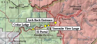
140号の今シーズン中の開通は無いと思われます。
旅行を計画される時にはご注意下さい。 June 19 2006
momokiyoさんの報告がありました:『El PortalのYosemite View Lodge、Cedar Lodgeと公園西側エントランスは、行き来可能です。』 ということで、現場はCeder Lodgeの西1−2マイルくらいのようです。地図:西からCedar Lodge、El Portal、Yosemite View Lodge、Arch Rock Entrance。(2006/06/01)
こちらのサイトに写真が出ています。
29日にはさらに崩壊しています。
NPSによれば、140号は6ヶ月は閉鎖しそうです。
We are facing a new reality regarding the rockslide on Highway 140 west of El Portal. The magnitude of recent slide activity has changed the projections from CalTrans significantly. CalTrans no longer expects to be able to restore the portion of the highway where the slide occurred, and is instead moving forward with options such as building bridges to allow the highway to cross the river. While no time estimates are available yet, it is reasonable to assume the 140 corridor will be closed at least through the summer and probably six months or more.
2006年05月30日
グレイシャーポイントロード開通
グレイシャーポイントロードが開通しています。
グレイシャーポイントからはいまだ雪に覆われたバックカントリーの景色が楽しめますよ。
The Glacier Point Road is open for visitors looking for a scenic drive or hike and a glimpse into Yosemite's still snow-covered backcountry.
2006年05月26日
108号開通
SR 108
[CENTRAL CALIFORNIA & SIERRA NEVADA]
NO TRAFFIC RESTRICTIONS ARE REPORTED FOR THIS AREA.
[EASTERN SIERRA NEVADA]
NO TRAFFIC RESTRICTIONS ARE REPORTED FOR THIS AREA.
108号は120号の北です。
120号(Tioga Road)が開くまでは、これでシエラ越えが出来ます。
140号開通=>閉鎖
今度は別の場所でクローズです。140は避けたほうがよさそうです。
SR 140
[CENTRAL CALIFORNIA]
IS CLOSED 20 MI EAST OF MARIPOSA (MARIPOSA CO) - DUE TO A ROCK SLIDE -
MOTORISTS ARE ADVISED TO USE AN ALTERNATE ROUTE - THE YOSEMITE NAT'L ENTRANCE
CAN BE ACCESSED FROM EL PORTAL RD.
[YOSEMITE NATL PARK]
FOR YOSEMITE NAT'L PARK ROAD INFORMATION CALL 209-372-0200
数箇所で一方通行ですが、開通しました。
SR 140
[CENTRAL CALIFORNIA]
1-WAY TRAFFIC CONTROL AT VARIOUS LOCATIONS FROM 3 MI EAST TO 11.5 MI EAST
OF BRICEBURG (MARIPOSA CO) - DUE TO A ROCK SLIDE - MOTORISTS ARE SUBJECT TO 15
MINUTE DELAYS
2006年05月22日
グレイシャーポイントロード状況
NPSによれば、すでにグレイシャーポイントまでの除雪作業が完了し、パーキングの倒木処理や清掃などの段階のようです。26日に開通する見込みのようです。
Glacier Point road progress - May 19, 2006
They have reached Glacier Point. They are now in the progress of cleaning the parking lots, patching potholes, removing a large boulder from the road, ditching, and sweeping. Forestry crews are also working up on the road. There are quite a few trees that need to be removed along with brushing operations. The road will be open to administrative traffic Monday and barring any problems, should be open to the public by some time late next week. (J. Cyr - 5/19/06)
140号閉鎖は5月29日まで?
Merced Sun-Starの記事によると、140号の閉鎖は5月29日まで続く可能性があるようです。
MARIPOSA -- A landslide on Highway 140 about 20 miles east of Mariposa is active, and the road may stay closed until May 29, Caltrans officials say.
2006年05月14日
YARTSバス運行情報
140号線の交通規制にともなって、YARTSバス140号線の運行が変更されていますので、ご注意ください。
YARTS will be running an adjusted schedule until Hwy 140 reopens. The schedule will be as follows:
Run 1 will NOT run.
Run 2 will run on the scheduled times up to the Hostel, then turn around and take Highways 49 and 41 into the park. It will not go to El Portal for stops.
Run 3 will run as scheduled up to the Hostel, then turn around and take Highways 49 and 41 into the park. It will not go to El Portal for stops.
Run 4 will NOT run-EXCEPT-the El Portal portion beginning with the 10:37am stops at Cedar Lodge and following the schedule for Barium, NPS, El Portal PO and Yosemite View Lodge as listed on Run 4. Persons wanting to get to any of these locations from the park should be at Yosemite Lodge by 9:45 am and may catch this bus to these El Portal locations only.
Run 5 will run on the scheduled times up to the Hostel, then turn around and take Highways 49 and 41 into the park. It will not go to El Portal stops.
Runs 6 and 7 will run as scheduled.
Run 8 will run; however it will not leave Curry Village until 11:30am, Ahwahnee at 11:35am, Visitors Center at 11:40am and Yosemite Lodge at 12 noon. This run will not go to El Portal. It will proceed around via Highways 41 and 49 to Midpines, Mariposa and Merced.
Run 9 will run on schedule for the valley floor pick-ups, however it will NOT go to El Portal. It will proceed around via Highways 41 and 49 to Midpines, Mariposa and Merced.
Run 10 will NOT run-passengers should take Run 11.
Run 11 will run on schedule from the Valley Floor and make all scheduled stops for drops and pickups in El Portal. This run will then turn around and proceed to Midpines, Mariposa and Merced via highways 41 and 49.
On May 1st, buses going around were arriving in the park about 1 to 1 1/2 hours later than times on the YARTS schedule, so plan accordingly. Unfortunately there is no way to give scheduled times for buses departing the park for passengers who want to leave from Midpines, Mariposa, or Catheys Valley to Merced. Passengers will have to be at these stops and wait. Suggest arriving at these stop 30 minutes later than the normal departure times to be safe, even though there may be a bit of a wait. There are no time guarantees, and we are unable to contact the driver once they leave the park, since most of the route is in a dead zone for cell phones. We will have the driver wait a minute or two extra and look around for passengers in case some are waiting inside a building or car.
Hopefully the road will be open soon and we can get back on the regular schedule. Until then, we will keep the schedule running as smoothly as possible. If there are any changes, we will be sure to notify you as soon as possible. Thanks for your cooperation. (W. Malone - 5/12/06)
2006年05月05日
140号線開通->閉鎖->開通
5月25日再開
5月10日夕方:再閉鎖
SR 140
[CENTRAL CALIFORNIA]
IS CLOSED FROM 3 MI EAST TO 11.5 MI EAST OF BRICEBURG (MARIPOSA CO) - DUE
TO A ROCK SLIDE - MOTORISTS ARE ADVISED TO USE AN ALTERNATE ROUTE
5月10日:一方通行で再開です
SR 140
[CENTRAL CALIFORNIA]
1-WAY CONTROLLED TRAFFIC FROM 3 MI EAST TO 11.5 MI EAST OF BRICEBURG
(MARIPOSA CO) - DUE TO A ROCK SLIDE
[YOSEMITE NATL PARK]
FOR YOSEMITE NAT'L PARK ROAD INFORMATION CALL 209-372-0200
ヨセミテヴァレーへアプローチするCA140線が現在、崖崩れのため閉鎖になっています。
120号線もしくは49号線へ迂回するルートでの入園が必要です。
SR 140
[CENTRAL CALIFORNIA]
IS CLOSED FROM 3 MI EAST TO 11.5 MI EAST OF BRICEBURG (MARIPOSA CO) - DUE
TO A ROCK SLIDE - MOTORISTS ARE ADVISED TO USE AN ALTERNATE ROUTE - THE
YOSEMITE NAT'L PARK ENTRANCE IS CLOSED
[YOSEMITE NATL PARK]
FOR YOSEMITE NAT'L PARK ROAD INFORMATION CALL 209-372-0200
2005年11月26日
Tioga Road閉鎖
何度目の再閉鎖でしょうか。木曜〜金曜の夜にかけて天気が悪化、朝に閉鎖したようです。
SR 120
[CENTRAL CALIFORNIA & SIERRA NEVADA]
IS CLOSED FROM CRANE FLAT TO 5 MI WEST OF THE JCT OF US 395 /TIOGA PASS/
(TUOLUMNE, MONO CO's) - DUE TO SNOW
2005年11月21日
白いSUVに要注意
帰りに、White Wolfの(閉じた)ゲートの前に駐車してあった白い大型SUVに気がつきました。
五分くらいすると、急速に追跡してくる同車をルームミラー内に発見。速度を落すと、車はすぐ後ろに
付き始めました。で、よく観察したところ:
1. 黒いドアミラーに、赤と青のライトが埋め込まれている。
2. カンガルーバンパーを付けている。
3. フロントグリルの中には赤青のライトが見えている。
4. ルーフには無線機のアンテナが立っている。
Turn aroundが出てきたので、早速道を譲り後から観察:
5. ライセンスは○に入った’E'があった。
6. 超薄型LEDタイプの信号灯がルーフについていた(前方からはよく見えません)。
7. ペイントは白のみ。何のロゴも無し。
前々から噂されていた、覆面パトカーとの接近遭遇でした。
[11-20-2005 by suyama]
偶然今日写真を撮りました。TMビジターセンター前にて。
せっかくの思いで写真を撮ったのですが、Yosemite Villageに行ったら多数見れました。
現在、Valleyでは、North Drive前工事により普段一般車が通れないビレッジ内道路が
一般に供用されていますが、その通り沿いにレンジャー詰所みたいな所が合って、
その前に覆面も含めパトロールカーが展示所の様にわんさか置かれていました。
あとPark Ranger Trafficとか書かれた赤いのもいます。
2005年11月17日
チェーン規制のサイン
Chain Control Signs
冬期にチェーン規制が出た際のサインについて解説がありましたので、掲載します。
R-1からR-3まで、3段階あります。
チェーン規制が出ているエリアでは最高速度は25マイル/時に規制されます。
「R-1」レベル
チェーンが必要。ただしスノータイヤもOK。(溝の深さ規定あり)
ロードサインは “AUTOS & PICKUPS SNOW TIRES OK”と出ます。
「R-2」レベル
チェーンが必要。スノータイヤを4輪に装着した4WD車はOK。(車両重量規定あり)
ロードサインは“4W DRIVE WITH SNOW TIRES OK”と出ます。
「R-3」レベル
4WD車も含め、例外なしにチェーンが必要。
ロードサインは“NO EXCEPTIONS”と出ます。
Chain Control Signs
Here is a reminder of what those chain control signs mean.
Remember the posted speed limit in the park is 25 mph when chain requirements are in effect. This speed limit overrides all higher posted limits within the chain control area. Road conditions may warrant speeds slower than what is posted, you must drive accordingly.
R-1 Chains are required − snow tread tires are allowed.
Park road signs will show “AUTOS & PICKUPS SNOW TIRES OK”. Snow tires must have a minimum tread depth of 6/32 of an inch to be legal.
R-2 Chains are required on all vehicles except four-wheel drive vehicles with snow tires on all four wheels. (This is for a four-wheel drive passenger vehicles with an unladen weight of 6500 pounds or less) Park road signs will show “4W DRIVE WITH SNOW TIRES OK”.
R-3 Chains are required − all vehicles − no exceptions. (Yes “all” means four-wheel drives too.) Park road signs will show “NO EXCEPTIONS”
Remember, State Law requires you to carry chains in your vehicle when entering an active chain control area. Tire traction devices can be link chain, cable chain and/or spider straps. For further information on winter driving tips go to www.dot.ca.gov/roadinfo/wntrdriv.htm (R. Middlecamp - 11/1/05)
また冬道ドライブのTIPSについても、以下のように掲載がありました。
WINTER DRIVING TIPS
Allow enough time. Get an early start, and allow plenty of time to reach your destination. Park roads, the Merced Canyon (Hwy 140) and Hwy 41 can be very icy, especially during December and January when the sun is at its southern-most point in the sky.
Slow down, a posted speed of 35 mph may be safe in dry, warm weather, but may be an invitation for trouble on snow and ice. Snow and ice make stopping distances much longer, so keep your seat belt buckled and leave more distance between your vehicle and the vehicle ahead, especially when approaching a stop sign (i.e., Sentinel Bridge). Bridge decks and shady spots can be icy when other areas are not. Remember to avoid sudden stops and quick direction changes.
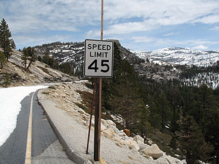
Chain Control Areas: The speed limit on park roads, in chain control areas, is 25 mph. Signs (Black with white lettering) are posted at the start of chain control areas and supersedes all higher limit signs (White with black lettering). The law requires that you drive the speed that is safe for the current road conditions, which may mean driving slower than the posted 25 mph. Drive Safely! (R. Middlecamp - 11/17/05)
2005年10月31日
Tioga Road

Tioga Roadはドライでした。積雪(5センチほど)は7,500ft.付近まであったようです。
日陰には雪が残っていました。朝の気温は30Fくらい、昼は50Fでした。
写真はPorcupine Flat CG前。

Tioga Road西側から見たMt. Hoffmann(左)
2005年10月01日
クリーン・バス・リーダー
NPSによると、The Environmental and Energy Study Institute (EESI)によって、今春導入されたヨセミテ国立公園のハイブリッド・シャトルバスのシステムが「National Clean Bus Leader for 2005」に選定されたようです。
2005年08月09日
エルキャピタンへの実験シャトル
8/9から21の2週間、これまでシャトルバスがなかったヴァレーの西方面へのシャトルバスの運行実験が行われます。8:00am-7:00 pmの間の毎時1便の運行です。
ビジターセンター、ヨセミテロッジ、エルキャピタンピクニックエリア、エルキャピタンメドウ、4マイルトレイル登山口の後、ビジターセンターへと戻ります。
期間中に利用された方は、ご感想をBBSにお寄せください。
AUGUST 9-21 - FREE EL CAPITAN SHUTTLE BUS LOOP
8:00am-7:00 pm - Departs hourly from Valley Visitor Center and Yosemite Lodge at the Falls
As part of a 2-week trial for a possible new shuttle bus route, visitors can board at the Valley Visitor Center (shuttle stop #5) and at Yosemite Lodge at the Falls (shuttle stop #8) for west Valley destinations. Stops include the El Capitan picnic area, El Capitan Meadow, and the Four Mile Trailhead, with a direct return to the Visitor Center. (N. Oswald - 8/05/05)
2005年08月05日
YARTSバス120号東線が運行延長
YARTSバス120号東線(ヨセミテヴァレー〜〜マンモスレイクス)は9月に入ると週末だけの運行になる予定でしたが、9月18日までは毎日運行されることになりました。また週末の運行はその翌週の9月24、25日までとなります。
Hikers and travelers to the high country will be glad to hear that daily YARTS service on the Hwy 120 east/395 route has been extended to include the first two weeks of September (through Sept. 18). It will then return to weekends only for the remainder of September.
Normally this service operates only on weekends in September, but the late opening of Tioga Pass Road prompted the YARTS Governing Board to provide the additional service.
The YARTS bus from Yosemite Valley to Tuolumne Meadows and Mono County leaves at 5 PM from the Valley Visitor Center. Reservations are not being taken this year, so seating is on a space available basis. Questions about the service can be resolved by visiting the YARTS web site at www.YARTS.com or by calling Dick Whittington at (209) 723-3153 x311. (D. Whittington - 8/04/05)
2005年07月02日
【注意】Holiday weekendの交通
今週末および独立記念日の祝日は来園者の集中が予想されるため、NPSでは
・できるだけマイカーをさけ、バスでの来場を
・9時以前の入場、18時以降の退場
・ヴァレー内、ワワナ〜マリポサグローブはシャトルバスを利用
を勧めています。
(筆者注)
混雑がひどいと、日帰り客(園内もしくはヴァレー内に宿泊予約のないビジター)のクルマでの入場が制限される可能性があります。ご注意ください。
Yosemite National Park is anticipating a large number of visitors over the holiday weekend. Visitors are advised to avoid peak traffic hours, and to use public transportation to the park if possible. Most traffic congestion can be avoided by coming before 9AM and leaving after 6PM. Visitors hoping to visit Yosemite Valley and the Mariposa Grove of Giant Sequoias are asked to use the free shuttle system in place in those areas.
Information about road, weather, and trail conditions is available during business hours by calling 209/372-0200. Information is also available online at www.nps.gov/yose.
2005年06月29日
YARTSバス(120号東線)の運行
7/1からヨセミテヴァレー〜マモスレイクス間のYARTSバス(120号東線)の運行が始まります。
The Yosemite Area Regional Transportation System (YARTS) will begin service on the Hwy 120/395 service corridor, between Mammoth Lakes and Yosemite Valley, on Friday, July 1st. Service in July and August is daily and there is one run per day in each direction. In September, the service is on weekends only.
As in the past, the Yosemite Valley bus will depart from the Valley Visitor Center at 5 PM, arriving in Tuolumne Meadows at approximately 6:45 PM and Mammoth Lakes at 8:50 PM, having made stops in Lee Vining and on the June Lake Loop. The inbound trip leaves Mammoth Lakes at 7:00 AM and arrives in the Valley at 10:50 AM.
Please refer to the YARTS manuals distributed to Park information centers, however if you have questions regarding the service you can call the toll free phone at 1-888-899-2787 or Dick Whittington, YARTS Transit Manager, at 209-723-3153 x311.(D.Whittington - 6/28/05)
2005年06月17日
タイオガロード状況
なかなか難航しているようで、いまだ開通予定日は発表されません。
除雪作業状況の頁では、オルムステッドポイント付近の落石の写真が出ていました。
センターライン付近まで巨石が落ちています。作業ご苦労様です。
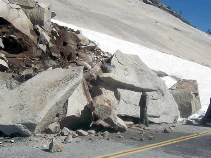
NPSによる写真
On June 14, crews began to remove boulders from this rockslide near Olmsted Point.
2005年06月14日
ハイブリッド・シャトルバス
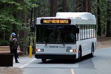
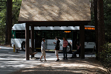
ミラーレイク・トレイルヘッドのバス停にて
今シーズンよりお目見えした新型のシャトルバスです。ガソリンエンジン+バッテリー+電気モーターのハイブリッドシステムを搭載して燃費と排気ガス性能が向上しています。
また主要バスストップも屋根付き工事が完了しています。
2005年06月11日
ヴァレー内交通規制
昨日ヴァレーから戻りました。
ヴァレー内はいたるところで道路工事をやっていて、ヨセミテヴィレッジ〜センチネル橋間が通行止めでした。そのためにカリービレッジ〜ヨセミテヴィレッジ間で恒常的に渋滞が発生していて、これには参りました。
YOSEMITE VALLEY ROADS (Various Repair Locations--Most of the work will occur at various areas on Southside Drive and Northside Drive between Bank 3-way and Camp-6 intersection)
June 6th thru June 10th Continue Microseal (Were trying to keep the delays under 15-minutes when we are working on the 2-way road sections. Most of the Southside Drive work will occur between El Capitan Crossover and Swinging Bridge, as well as at the south end of the Sentinel Bridge. We'll also be working again on Northside Drive between Bank 3-Way and Camp-6 and possibly a few other areas (work in the other areas is dependent upon how work progresses throughout the week). No further microseal work is scheduled after June 10th.
***June 8th thru June 10th Microseal one lane of Northsdrive between El Captian Crossover and Pohono Bridge - one lane of traffice will remain open at all times.
June 13th and beyond There may be some asphalt overlay and patching work in a few small areas at various locations throughout the summer
During 6:00 AM to 8:00 AM and 4:00 PM to 6:00 PM (commuter hours) Monday thru Friday, the delays will be kept to 15-minutes maximum. Also, the hours of work with 30-minute delays may vary from day to day depending upon the weather and traffic conditions
SOUTH FORK BRIDGE REPLACEMENT
June 6th thru June 10th Complete Bridge Demolition (This may be a bit optimistic, but they are planning to have the majority of the bridge demolition completed on June 10th--however they are planning to leave parts of the piers for the new bridge falsework support) (There may be some minimal delays moving equipment and trucks in and out of the site.)
June 13th thru June 17th Begin excavation and formwork for the new abutments.
2005年05月27日
マリポサグローブ
マリポサグローブへの大型車の通行規制が解除され、ワワナからのシャトルバスの運行も5/26から始まりました。またトラムのツアーも始まるようです。
The Mariposa Grove Road will be open to buses, including park shuttle buses, beginning on Thursday, May 26, 2005. Wawona shuttle service to the Grove will begin on Thursday afternoon. DNC will announce the beginning of MG trams. (T. Ludington & K. Tucker - 5/25/05)
2005年05月23日
除雪状況(続)
公式サイトによるとグレイシャーポイントロードは5/27の開通予定のようです。
タイオガロードはまだ未定です。除雪作業がんばれー!
The Tioga Road is closed for the winter. It usually reopens in late May or early June, however a wet winter and spring may result in a later opening than usual. The Glacier Point Road is also closed; the projected opening is May 27, 2005, conditions permitting.
2005年05月07日
Mariposa Grove Roadオープン!
公式サイトのConditions Updateによると、5/6の16時の更新から
Mariposa Grove Road (open to cars/SUVs only):Open
となっていました。
(この表記だと普通車とSUVはOK。大型RVやバスは未だ通れないということなのでしょう。)
2005年05月03日
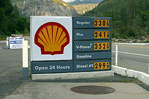
2005年04月22日
140号線の通行規制
工事のため140号線の通行規制が行われます。最大15分〜30分の遅れ(交互通行)になります。
期間:4月18日〜5月25日
区間:エルポータル(Yosemite View Lodge前)〜Big Oak Flat Road分岐
----
Upcoming road work on the El Portal Road between Yosemite View Lodge and the former Cascades Diversion Dam.
Please be aware there will be traffic delays on 7-miles of the El Portal Road (Ref. CA St. Hwy. 140) between Yosemite View Lodge and the former Cascades Dam intersection (Big Oak Flat Road & El Portal Road Intersection) starting next Monday, April 18th. See the following proposed schedule for specific details of work and dates of these delays.
April 18th thru April 22nd Surveying Work with up to 15-minute delays. (Monday April 18th work will begin at 12:00 Noon)
April 25th thru April 29th Asphalt Patching with up to 30-minute delays.
May 2nd thru May 6th No work and no delays.
May 9th thru May 13th Microsealing with up to 30-minute delays.
May 16th thru May 20th Surveying, Striping and Placement of Centerline Delineators
May 23rd thru May 25th Striping and Placement of Centerline Delineators
During 6:00 AM to 8:00 AM and 4:00 PM to 6:00 PM (commuter hours) Monday thru Friday, the delays will be kept to 15-minutes maximum.
Please understand the schedule may change depending upon the weather conditions and I will keep you posted if there are changes. However, if you have any questions or concerns please contact me at (209) 379-1263 or email me and I will make every effort to address your concerns promptly. (M. Pieper - 4/15/05)
2005年04月15日
除雪作業/タイオガロード・グレイシャーポイントロード
NPSによると、タイオガロードの除雪作業は4/15から、グレイシャーポイントロードは4/18から始まるようです。なお開通日はまだ未定です。
今年は雪が多そうですから、5月中旬以降にずれ込むこともあるでしょう。
詳細と進行状況は以下のページでチェックできます。
http://www.nps.gov/yose/now/tioga.htm
---
Plowing of the Tioga Road will begin on April 15th (and on April 18th for the Glacier Point Road).
2005年03月21日
2005年03月09日
ハイブリッド・シャトルバス
NPSのDaily Reportによるとヴァレー内のシャトルバスが4月からハイブリッドシステムを搭載した新型車にリプレイスされるらしく、1号車が昨日到着したようです。燃費の大幅な改善と有害物質や騒音の削減ができるということです。
The 1st of 18 new hybrid electric shuttle buses will be arriving in Yosemite Valley today. The remaining 17 will be delivered to the park over the course of the next two months. The new hybrid fleet will replace the existing fleet of 1986 diesel buses currently servicing the in-Valley shuttle route. Hybrid electric propulsion technology, which was built by General Motors Allison Transmission Division, will significantly reduce fuel consumption (by up to 55%), harmful emissions (by up to 90%), and vehicle noise. The 1st bus will be used to train drivers and mechanics, so it won't see visitor service until April; however, the good folks who operate and maintain the shuttle system (Delaware North Company) will be happy to show it off to interested park employees. Be on the lookout for the new white and green "Yosemite Shuttle" bus with the battery pack on the roof ! (M. Wichmann - 3/8/05)
2005年01月16日
120号
Big Oak Flatゲート〜Merced Grove〜Crane Flat付近の道路(写真)には結構雪が残っていました。
チェーン規制こそありませんでしたが、雪上の運転となるので注意が必要です。 渓谷内の道の一部は朝には凍っていました。 Badger Passへの道路にもチェーン規制は入っていませんでした(一部雪あり)。
Big Oak Flat(Grovelandの西)への近道Old Priest Road(急登)は一週間前からクローズになったとのことです。
2005年01月10日
Yosemite 近況
雪のため(加えて雨による道路凍結のため)、ヨセミテバレーに出入りする道路は
140号〜エルポータルロード以外の全てが今朝は通行止めでした。
バレーからトンネルビューにも行けませんでした。
バジャーパスのスキーエリアも閉鎖中です。
雪が降りすぎて閉じてしまうとは…。
2004年12月25日
Northside Driveの通行規制
NPSによると12/20から年明けの3/31の期間中、ヴァレー内のNorthside Drive(通常は西行きの一方通行)が閉鎖となります。そのかわりSouthside Drive(通常は東行きの一方通行)が対面通行となります。
運転にご注意ください。
---
Northside Drive has been closed between Camp 4 (site of old gas station) to Pohono bridge from December 20th, 2004 - End of March 2005. Southside Drive is open to two way traffic. Please drive carefully and observe all speed limits.
2004年12月12日
120号の状況
今週初めの嵐は、Big Oak Flat付近にもかなりの降雪をもたらしたようです。
料金所から先の120号には、滑り止め用の砂がかなりまかれています。
所々路面が濡れているので、気温が下がっているときの運転には注意が必要です。
このような感じの路面状況では、まずチエーン規制はありません。
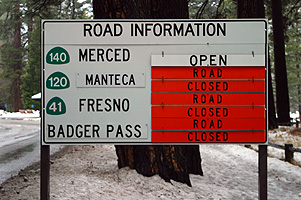
2004年10月29日
Tioga Road & Glacier Road
正式アナウンスメントは見あたりませんでしたが、今朝のアップデートでGlacierRoad及びTiogaRoadは単純にClosedとだけ表示されるようになりました。代わって、『TuolumneMeadowsWinterConditionsUpdate』が始まりました。
これは、公園当局が今年は両道路の再開通に積極的に動かないものと推察いたします。
http://www.nps.gov/yose/now/conditions.htm
今年GlacierPointに行くつもりだった方、まだ諦めるのは早い。4マイル・トレイルはまだ開いています。
そして、BadgerPassスキー場が開業すれば、GlacierRoadのグルーミングが始まります。GlacierPointまでXCスキー用トラックも整備され、GlacierRoad上はレンジャーのパトロールも入りますので、比較的安全に冬の絶景を独り占めできます。用具レンタルもあります。
通常は12月開業ですが、今年は早く開業するかもしれません。BadgerPassスキー場の開業情報をお待ちください。
http://www.yosemitepark.com/activitylist.cfm?SectionID=81&PageID=246
2004年10月24日
120号道路工事
120号は避けて、140号を使われたほうがよさそうです。
既に工事は始まっています。
Big Oak Flat Road (Highway 120 west inside the park) between Crane Flat and Yosemite Valley
Delays of up to two hours are possible, with more frequent delays of up to 30 minutes.
詳しくは
http://www.nps.gov/yose/now/roadwork.htm
にあります
2004年10月20日
雪です
ヨセミテは雪です。タイオガロード(クレーンフラット〜タイオガ峠)、グレイシャーポイントロードは積雪のため閉鎖となっています。また公式サイトではマイカーでの来園者に対して必ずタイヤチェーンを準備するようにと注意しています。
(写真はセンチネルドームのWebカメラより)
---
Tioga Road (between Crane Flat and Tioga Pass) and Glacier Point Road is closed due to snow accumulation. Call 372-0200 and follow the prompts for updates.
---
Carry tires chains in your car and be prepared to use them (even if you have four-wheel drive): chains may become mandatory at any time.
2004年07月16日
グレイシャーポイントロード閉鎖
山火事のため、現時点(Pacific time 7/15午前11時20分)でグレーシャーポイントロードはブライダルベールクリークキャンプ場から閉鎖されています。道路事情アップデートは209/372-0200で入手できます。
2004年06月19日
スピード違反に御注意
公園内はレンジャーがスピード違反の取締りを行っています。
道路を横断する人や路肩駐車からの出入りが多そうな、人と車が混在する区域は、25マイルに規制されており、人が飛び出してくる危険性がある危険なエリアですので、十分な注意が必要です。そして、このエリアでネズミ捕りを良く見かけます。夏の昼間、ランバートドーム頂上から、この様子が双眼鏡で良く観察できます。
先週まで、さすが国立公園、危険な地域を重点的に監視する合理的なすばらしいシステムだと感心していました。
しかし、先週末の深夜、私は何とバレー内の35マイル規制エリアで捕まりました。確かに昼間は、観光客が頻繁に道路を横断する可能性がある要注意エリア。しかし、時間は真夜中、人っ子一人いないというのに。個人的には、真夜中にそんな所を35マイルで走る奴がいるか、レンジャーが罰金を集つめのネズミ捕り等するな、と言いたいような場所です。頭に血が上ってましたので、かなり強気な交渉で徹底的に粘った結果、身元確認のみで無事解放されましたが、30分は無駄にしてしまいました。
ネズミ捕りは25マイル規制エリア以外でも行われています。どんな状況であっても、法定速度を遵守しなかった私が悪かった訳で、皆さんも十分注意して安全運転を心がけましょう。
2004年06月14日
GAS price
今週も El Portal は値段据え置きでした。
この写真はYosemite Lake のキャンプ場のところ。(120号で公園外最寄のGS)
先週は確認していませんが、メモリアルデーの週末は2ドル台でした。
ここまで高いと、ちょっと記念に給油したい感じです。
いちおう、下界では下降傾向が出始めているようではあるのですが…
2004年05月27日
クルマ通行規制
NPSによるとBig Oak Flat Road、El Portal Roadで道路舗装工事の為、5/24-25,6/2-3の期間通行規制があります。"20 minute delays"はおそらく20分間間隔の片側通行です。
Big Oak Flat Road (Highway 120 from Manteca):
20 minute delays May 24-26, June 2-3 just west of Y. Valley
El Portal Road (Highway 140 from Merced):
20 minute delays May 24-26, June 2-3 just west of Y. Valley
2004年05月20日
ガソリン高騰…
これはLee ViningのGas Station(5/15の価格)ですが、
場所によっては$3.00超えているのでしょうね。(Bridgeportなど)
そのうち牛乳より高くなるのでしょうね。悩ましいです。
この週は、Lee Vining>June Lake>Mammoth Lakesでした。(常にこの関係というわけではないです)

2004年05月18日
冬季道路閉鎖解除・残雪状況
開通週末のTioga Road, Glacier Pt Roadの状況を観察してきました。
すでに報告されているように今年この時期の残雪はかなり少ないです。
道路沿いにはほとんど雪がありません。昨年の6月中旬程度かそれ以下です。
例年、開通後は水量の豊富なTamarack Fallsなどの滝も勢いはなく、
Tuolumne Meadowsも洪水状態はもう終わった後のような感じです。
どちらの道路も各枝道(May Lake等)はまだどこも閉鎖中ですが、やはり雪はありません。
積雪の量だけでなく、開通直後のハイカントリーへの来訪者の多さにも例年との違いを感じました。
グレイシャーポイントも駐車スペースが見つけられないくらいに混雑していました。
2004年05月04日
Tioga Road の状況
今日届いたYosemite Newsletterによれば、
Tioga Road は5/14の開通前の現在、
すでにヨセミテクリークまでは西側から行けるということですね。
> For those who want to get an even earlier glimpse of the park's high country, the Tioga Road is currently open from Crane Flat to Yosemite Creek.
詳細は以下。
http://www.nps.gov/yose/news/2004/tiog0430.htm
4/30からそうだったのかな?
2004年05月01日
シエラの峠道 開通予定日
という訳でBBSにあるように今シーズンの
タイオガロードは5/14,
108は5/6開通予定とのことです。
第一報告者のKleiberさんすやまさん速報ありがとうございます!
2004年04月30日
タイオガロード除雪状況(4/29)
4/27のNPSアップデートによると、西側と東側の除雪がつながったそうです。
ただすぐの開通にはいたらないようです。
”4/27/2004
Today, NPS road crews met up with the Mono County road crews. Although the road is now plowed through, there is still a lot of work to do to make the road safe, and to get everything else ready for an official opening”.
CALTRANSによると395とタイオガロードの交差点から西12マイル地点
(タイオガパス付近でしょうか)まではいけるようです。
つい数日前は5マイル地点までしかいけませんでした。
”SR 120
[CENTRAL CALIFORNIA & SIERRA NEVADA]
IS CLOSED FROM CRANE FLAT TO 12 MI WEST OF THE JCT OF US 395 /TIOGA PASS/
(TUOLUMNE, MONO CO's) - WINTER CLOSURE - THE YOSEMITE NAT'L PARK WEST ENTRANCE
ON SR 120 IS OPEN”
またヨセミテの北108号の除雪も進んでおり。西側はSonora Passの急登が始まる地点まで
車でいけるようです。
”SR 108
[CENTRAL CALIFORNIA & SIERRA NEVADA]
IS CLOSED FROM 26.4 MI EAST OF STRAWBERRY TO 12 MI WEST OF THE
JCT OF US 395 /SONORA PASS/ (TUOLUMNE,MONO CO's) - WINTER CLOSURE ”
CALTRANSのサイトで108、120とエンターしてみてください。
2004年04月24日
タイオガロード除雪状況(4/21)
4/21/2004
Starting Location: 24 miles from Crane Flat
Ending Location: 28.4 miles from Crane Flat (Olmsted Point)
Average snow depth: 3 feet
Mono County has begun to plow into the park from Tioga Pass. Their progress for today was one mile. They are in very dense and deep snow. Average depth is five feet with drifts of up to eight feet.
2004年04月22日
ラスベガス発ヨセミテ
こんなツアーを見つけました。(いつからあったのかな?)
ラスベガスからマーセドに飛行機で飛び、バスに乗り換えてヨセミテに入る日帰りツアーです。
参加費は大人299ドル。子ども249ドル。
またラスベガス−マーセド間の定期フライトを飛ばしています。
シーニック航空のサイトへ
2004年04月19日
タイオガロード除雪状況(4/17)
4/17/2004
Starting Location: 14 miles from Crane Flat
Ending Location: 19.8 miles from Crane Flat (Yosemite Creek Grade)
Total distance plowed: 5.6 miles
Average snow depth: 3 1/2 feet
2004年04月17日
タイオガロード除雪作業開始!
タイオガロードの除雪作業が4/15から開始されています。
いまのところ開通日は未確定のようです。最新情報はこちらでどうぞ。
http://www.nps.gov/yose/now/tioga.htm
たしかにオルムステッド・ポイントのあたりは道路上を除雪しても、上からどんどん崩れたり解けたりしてきますから、なかなか大変な作業のようですね。
Badger Pass Ski AreaやCrane Flat Snow Play Areaの営業も終了し、
タイオガロードの除雪も始まったというのに、この週末は天気が崩れ、
低地は雨、ヨセミテは高いところではまとまった雪が降りました。
ワヲナ道路・ビッグオークフラット道路でもそこそこの積雪がありました。
こうやって一進一退で夏へ向かっていくのを肌で感じるのも一興です。 (4/18 suyama)