News アーカイブ
- 2013年10月17日 ヨセミテ国立公園、再オープン!
- 2013年10月03日 シャットダウン2
- 2013年10月02日 シャットダウン
- 2013年09月22日 CA 120 (Tioga Rd), CA 108 雪のため閉鎖
- 2013年09月15日 Tioga Rd 開通
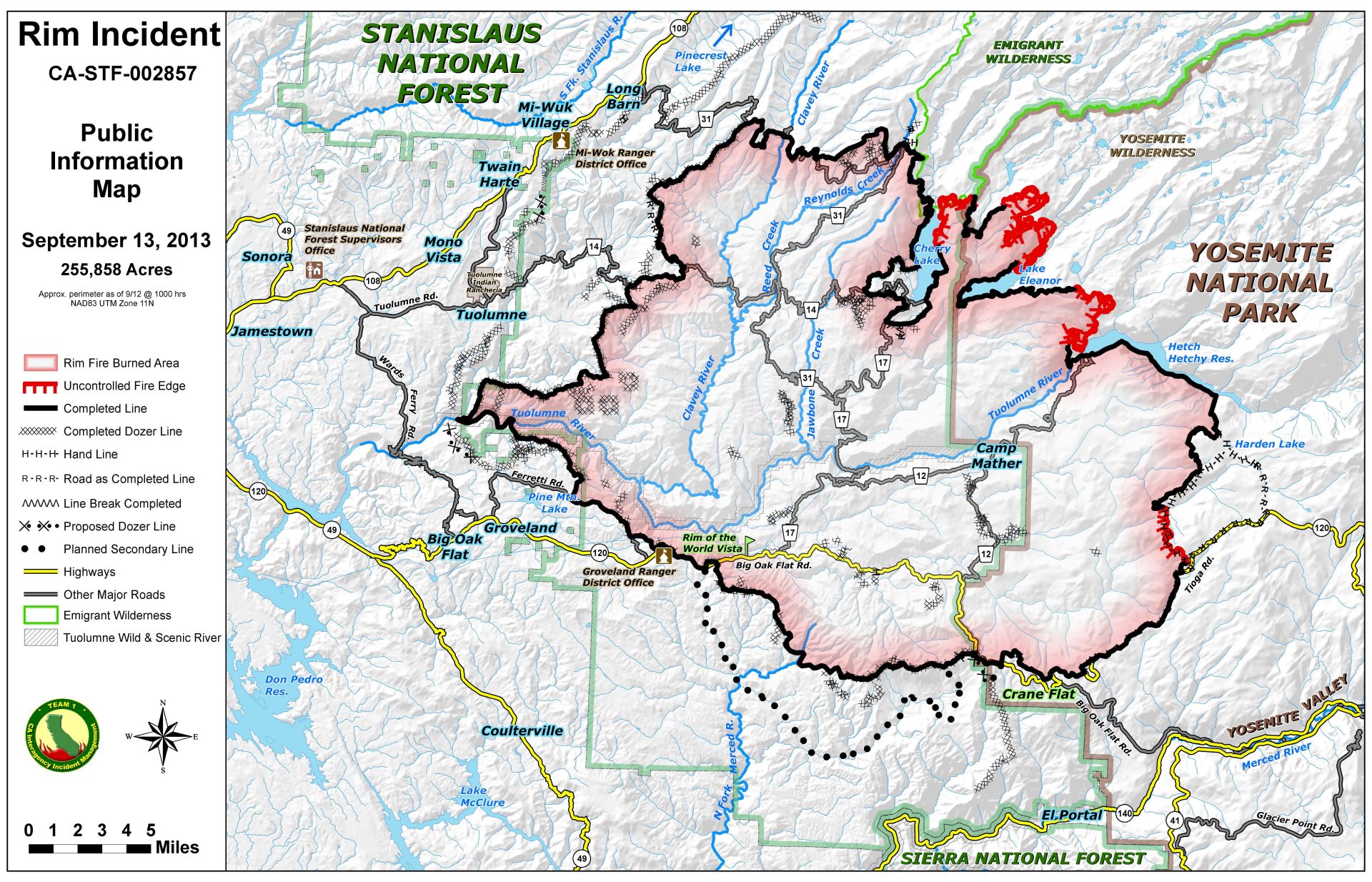
- 2013年09月14日 RIM FIRE
- 2013年09月12日 RIM FIRE
- 2013年09月10日 RIM FIRE
- 2013年09月07日 RIM FIRE (CA120 reopen)
- 2013年09月06日 RIM FIRE
- 2013年09月04日 Rim Fire
- 2013年09月01日 Rim Fire (time lapse)
- 2013年09月01日 キャンプ終了
- 2013年09月01日 Rim Fire
- 2013年08月31日 Rim Fire
- 2013年08月30日 Rim Fire
- 2013年08月29日 Rim Fire
- 2013年08月28日 RIM FIRE
- 2013年08月27日 Rim Fire
- 2013年08月18日 SFベイブリッジがクローズ(8/28-9/3)
- 2013年08月13日 BBSのURL変更
- 2013年05月04日 トークイベント「西村仁志、ヨセミテ国立公園を語る」(5/19京都)を開催します
- 2013年05月04日 Tioga Rd. update / GP open
- 2013年05月01日 タイオガロードの開通は5/11の予定
- 2013年04月18日 Tioga Rd.除雪は4月15日から開始
- 2012年12月21日 Tuolumne Meadowsの越冬レンジャーからのリポート
- 2012年11月10日 今週末は積雪予報
- 2012年09月13日 NPSよりメール:ハンタウイルス
- 2012年09月08日 ハンタウイルスについて
- 2012年06月13日 White Wolf Campground is now open
- 2012年05月30日 ハーフドーム頂上のワイヤーケーブルが設置
- 2012年05月16日 ヨセミテ滝カメラ
- 2012年05月14日 HDトレイルOpenは5月25日の予定
- 2012年05月08日 Tioga Road開通
- 2012年05月03日 Tioga Rd. 7日開通予定
- 2012年04月27日 Tioga Rd.除雪完了、残すは修理保全作業。
- 2012年04月24日 Tioga Rd.除雪、Olmsted Pt.に到達
- 2012年04月21日 Tioga Rd. 除雪、Yosemite Creekに到達
- 2012年04月20日 Glacier Point Road明日 開通予定
- 2012年03月25日 Above Yosemite and Mono Lake
- 2012年02月17日 BadgerPassスキー場レポート(2/16)
- 2012年01月15日 2012年シーズンのハーフドーム登頂の許可情報
- 2011年06月10日 キャンプ場予約システムについての変更
- 2011年05月23日 Tioga Pass情報(Lee Vining側)
2013年10月17日
ヨセミテ国立公園、再オープン!
待ち望んでいた再オープンです!
----
Yosemite National Park Reopens to Visitors
Yosemite National Park reopens to park visitors tonight, October 16, 2013. Visitors can access public areas and roads immediately while facilities and other public services are brought back on-line. Yosemite National Park has been closed since October 1, 2013 due to the government shutdown.
"We are excited to reopen and welcome visitors back to Yosemite," stated park superintendent Don Neubacher. "Autumn is a particularly special season to enjoy Yosemite’s colorful grandeur."
Major highways and roads leading into and through Yosemite National Park, including the Glacier Point and Mariposa Grove roads, are open to vehicles. Park visitor centers will reopen and Ranger-led programs will resume on October 17. Visitors are urged to consult the Yosemite Guide for a list of programs.
Valley campgrounds in Yosemite will reopen on October 17. Those with reservations will be able to check in by noon. First come, first serve sites at Camp Four, Wawona and Hodgdon are also available.
Delaware North Parks & Resorts at Yosemite, Inc., the park’s primary concessioner, is reopening facilities and will begin to welcome guests immediately.
The Ansel Adams Gallery, located in Yosemite Village, will also reopen.
2013年10月03日
シャットダウン2
シャットダウンはなかなか辛い状況ですね。
サンフランシスコ・クロニコル紙の記事2本
2013年10月02日
シャットダウン
10月1日から全米の国立公園・国立史跡等の国立公園局管理箇所がクローズされました。
これは連邦議会におけるオバマ大統領のヘルスケア法に関する長期間にわたる論争によって、暫定予算法案の成立が遅らせられたことによります。
これによって、一部の政府機関の職員が出勤停止になり、一時閉鎖になっています。
クローズはもちろんヨセミテ国立公園も例外ではありません。
また、国立公園局のWEBサイトもクローズしています。
http://www.nps.gov/shutdown/index.html
いつまで続くかは不明です。
一刻も早い再開を望みます。
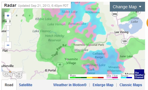
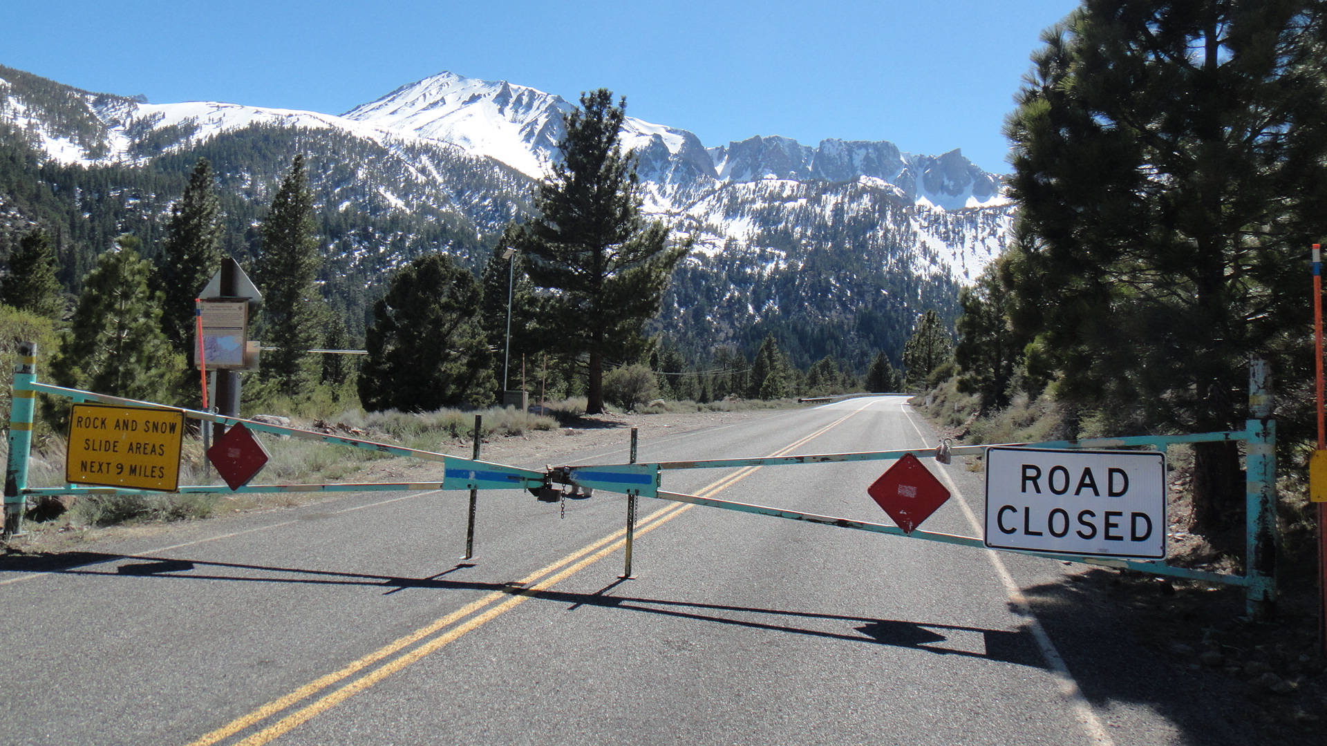
2013年09月22日
CA 120 (Tioga Rd), CA 108 雪のため閉鎖
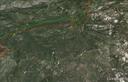
今日ベイエリアには雨がかなり降りました。前線はセントラルバレーを越えてシエラの山に移動、現在Tioga Rdは雪のためクローズしています(一時的ですが)。 Rim Fireの沈静化にはかなり貢献しそうです。Web CamではValleyは雨。
Current Situation
Total Personnel 1,321
Size 256,895 acres
Percent Contained 84%
Estimated Containment Date Tuesday October 01st, 2013 approx. 12:00 AM
SR 120
[IN THE CENTRAL CALIFORNIA AREA & SIERRA NEVADA]
IS CLOSED FROM CRANE FLAT TO 12 MI WEST OF THE JCT OF US 395 /TIOGA PASS/
(TUOLUMNE, MONO CO) - DUE TO SNOW - MOTORISTS ARE ADVISED TO USE AN ALTERNATE
ROUTE
R 108
[IN THE CENTRAL CALIFORNIA AREA & SIERRA NEVADA]
IS CLOSED FROM 7.2 MI EAST OF STRAWBERRY TO 5.3 MI WEST OF THE
JCT OF US 395 /SONORA PASS/ (TUOLUMNE,MONO CO) AT 1730 HRS ON 9/21/13
- DUE TO SNOW - MOTORISTS ARE ADVISED TO USE AN ALTERNATE ROUTE
2013年09月15日
Tioga Rd 開通
Special Road Update
Tioga Pass Road (Hwy 120 east) across Yosemite National Park to Tuolumne Meadows and Lee Vining (Hwy 395) opened at noon today. For safety visitors are not permitted to stop along the road adjacent to the fire perimeter.
http://inciweb.nwcg.gov/incident/3660
2013年09月14日
RIM FIRE
Current Situation
Total Personnel 2,170
Size 255,858 acres
Percent Contained 80%
Estimated Containment Date Friday September 20th, 2013 approx. 12:00 AM
Significant Events
Approximately 9 miles of fire perimeter in the eastern area of the fire and within Yosemite National Park has been declared contained.
White Wolfそばの包囲線が広がっています。
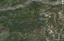
2013年09月12日
RIM FIRE
東端のRRRRのラインがTioga RoadからWhite Wolfeへの道路。White WolfeからHarden LakeまでHHHHは林道(Old Tioga Roadの一部)。Harden LakeからTuolumne渓谷のリムまではトレイル。ここが防衛線のようです。
Road Openings
Evergreen Road is opened to Evergreen Lodge. State Hwy 120 is open to Crane Flat. The Big Oak Flat Road is open. Businesses are open and providing services (gasoline food and lodging) for travelers.
Current Situation
Total Personnel 2,764
Size 255,560 acres
Percent Contained 80%
Estimated Containment Date Friday September 20th, 2013 approx. 12:00 AM
2013年09月10日
RIM FIRE
Current Situation
Total Personnel 3,027
Size 253,332 acres
Percent Contained 80%
Estimated Containment Date Friday September 20th, 2013 approx. 12:00 AM
9月8日のデータを赤でプロット。
動員数は約3000とピークから2000にほど減っています。
2013年09月07日
RIM FIRE (CA120 reopen)
Highway 120 Opening Today at 12pm
Incident: Rim Fire Wildfire
Released: 11 hrs. ago
NEWS RELEASE
For Immediate Release
STATE ROUTE 120 FROM GROVELAND TO YOSEMITE NATIONAL PARK WILL REOPENRoad opens at Noon on Friday September 6
State Route 120 (SR-120) from Groveland CA into Yosemite National Park will reopen to all vehicular traffic at noon Friday September 6 2013.
Visitors will have full access to Yosemite Valley via SR-120. However due to continued fire activity in the area stopping along the roadway is strictly prohibited. The public is advised to use extreme caution as firefighting activities continue in this area.
Cherry Lake Road Evergreen Road Old Yosemite Road Harden Flat and all other secondary roads and trailheads off of SR-120 remain closed.
SR-120 (Tioga Road) remains closed from Crane Flat to White Wolf within Yosemite National Park. Park visitors can access the Tuolumne Meadows area from SR-395 via the parks east entrance at Tioga Pass.
For updated road conditions and information visit Caltrans’ website: www.dot.ca.gov/ or call Caltrans District 10 Public Affairs Office at (209) 948-7977.
This highway information is the latest reported as of Friday, September 6, 2013 at 18:58 .
SR 120
[IN THE CENTRAL CALIFORNIA AREA & SIERRA NEVADA]
NO TRAFFIC RESTRICTIONS ARE REPORTED FOR THIS AREA.
[YOSEMITE NAT'L PARK]
IS CLOSED FROM 8 MI EAST TO 26 MI EAST OF THE
WEST YOSEMITE NATIONAL PARK BOUNDARY (TUOLUMNE CO) - DUE TO A WILD FIRE
- MOTORISTS ARE ADVISED TO USE AN ALTERNATE ROUTE
FOR YOSEMITE NAT'L PARK ROAD INFORMATION CALL 209-372-0200
2013年09月06日
RIM FIRE
Current Situation
Total Personnel 3,634
Size 237,341 acres
Percent Contained 80%
Estimated Containment Date Friday September 20th, 2013 approx. 12:00 AM
9月5日のデータは水色。
火事の原因はハンターによる火の不始末のようです。National Forest内でマリワナなどを違法栽培するケースが多々ありますが、今回はそれとは関係ないとのことです。さらに調査の必要があり、ハンターの名前はまだ公表していません。
Forest Service Releases The Cause of The Rim Fire
Incident: Rim Fire Wildfire
Released: 10 hrs. ago
NEWS RELEASE
U.S. Forest Service
Pacific Southwest Region
Contacts: Stanton Florea, Pacific Southwest Region, Public Affairs (707) 562-9014
Ray Mooney, Pacific Southwest Region, Public Affairs (707) 562-8995
http://www.fs.usda.gov/r5
Investigators discover cause of Rim Fire
VALLEJO, Calif., Sept. 5, 2013 - Investigators from the U.S. Forest Service Law Enforcement & Investigations and Tuolumne County District Attorney's Office have determined the Rim Fire began when a hunter allowed an illegal fire to escape. There is no indication the hunter was involved with illegal marijuana cultivation on public lands and no marijuana cultivation sites were located near the origin of the fire. No arrests have been made at this time and the hunter's name is being withheld pending further investigation.
The Rim Fire began Saturday, Aug. 17, 2013, on the Stanislaus National Forest near the area known as Jawbone Ridge. The fire has burned 237,341 acres and is 80 percent contained.
2013年09月04日
Rim Fire
Basic Information
Incident Type Wildfire
Cause Under Investigation
Date of Origin Saturday August 17th, 2013 approx. 03:15 PM
Location Groveland Range District, Stanislaus NF
Incident Commander Wilkins/lawshe
Current Situation
Total Personnel 4,185
Size 235,841 acres
Percent Contained 80%
Estimated Containment Date Friday September 20th, 2013 approx. 12:00 AM
2013/Sept/2 のデータをマゼンタでプロット。各方面で避難勧告解除が出始まりました。
Webに訂正があり、9月20日が100%containmentのターゲットのようです。また、動員数も4,200と減っています。
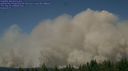
2013年09月01日
キャンプ終了

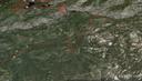
グレイシャー・ポイントから望む「RIM FIRE」(2013.8.29 19:39)
昨日無事、ベイエリア・サンフランシスコに戻ってきました。
RIM FIREの影響をもろにうけました。
8/28の正午でタイオガロード(クレーンフラット〜ホワイトウルフ)がクローズという通知があり、Tuolumune Meadowsでの日程を切り上げ、Wawonaのキャンプ場に引っ越しました。
途中、タイオガロードのすぐ近くまで火が迫っているのがみえました。(Fire Departmentが迎え火を打っていたのかもしれません)
Wawonaで2泊を過ごしましたが、29日のサンセットを見にグレイシャーポイントにあがったところ、大規模な煙が上がっていました。
これは雨がくるまでは消えないでしょうね。
ベイエリアに戻ってきたら、こんどはベイブリッジのクローズです。
今回は迂回だらけのキャンプとなりました。
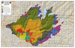
Rim Fire
Sierra Wildland Fire Reporting Systemで、Crane Flat のヘリーポートからの写真が見れます。
8月20日9時9分までは東南東(Gin Flat方面)を向いていますが、9時20分から北西に向けられ、煙が写っています。23日にはかなりの煙が上がっています。
Crane Flat Helibaseからの写真 [okをクリック、画面が出たら日付と時間をプルダウンメニューで指定]
動員数役5千人、Containment Dateが9月20日から10月20日になったようです。
Current Situation
Total Personnel 4,995
Size 219,277 acres
Percent Contained 35%
Estimated Containment Date Sunday October 20th, 2013 approx. 12:00 AM
8月31日のデータをオーバレーイ。青が31日のライン。
郡境界ははずし、120、Tioga Rdを黄色でプロット。
Crane Flat Helibaseの位置を追加。 ヨセミテバレーにはついに煙が入り、視界が落ちています。
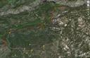
2013年08月31日
Rim Fire
Greenは28日、赤は今日30日のデータ。
Merced、Tuolumne Glove、Crane Flat、Crane FlatからTioga Rdを4マイルほど上ったGin Flat。
マーカーT5、右側に滝の見えるところをプロット。
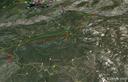
2013年08月30日
Rim Fire
InciWebページの右端中ほどにIncident Perimetersの欄があり、火災の広がりの状況がGoogleEarthで読み込め、オーバーレイできます。
http://inciweb.nwcg.gov/incident/3660
以下はBofエントランス、120号とHetch Hetchyへ向かうEvergreenの交差点、
EvergreenとOld Tioga Roadの交差点、Aspen Valley、White Wolfを28日のデータとともにプロットしたものです。fire lineはおおよそOld Tioga Roadに沿っています。
[Old Tioga Road(未舗装)は、EvergreenからAspen Valleyまでは許可のある車両のみ通行できますが、そこから東側White Wolfeまでは廃道化しており、沢にかかる橋も落ちています]。
下側、小さな写真のアイコンが多く見られるところが現在のTioga Rd.が走っているあたり。緑の線はTuolumneとMariposa郡の境界(TuolumneとMerced水系の分水界)。
2013年08月29日
Rim Fire
RIM FIRE INFORMATION
Update #19
Release for Wednesday, August 28, 2013/Time: 6:30 PM
Incident Statics
Acres Burned: 192,466 (301 square miles) Structures Threatened: 4,500
Containment: 30% Structures Destroyed: 111
Fire Start Date: August 17, 2013 Injuries: 4
Fire Cause: Under Investigation Total Personnel: 4,537
Cost to date: $39.2 Million
4500+まで増員されています。firelineは30%ほど(先週末は5%~7%)。
Bofエントランスのすぐそばまで火が迫っているようです。
Tuolumne水系の公園西側、ヨセミテクリーク西側、Mt. Hoffmann西側は閉鎖されています。
http://www.nps.gov/yose/planyourvisit/upload/rimfireclosure-082713.pdf
よく使われる”Contained/Containment"について
How Do You Rate a Forest Fire?
Chris Suellentrop
Posted Wednesday, Aug. 15, 2001, at 5:03 PM ET
Most of the news stories about the 43 large wildfires in the Western United States report some level of "containment" reached by firefighters. What does it mean to contain a fire, how is the percentage calculated, and when is a fire "controlled"?
To prevent a blaze from spreading, firefighters dig a "fire line" around its circumference. If three miles of fire line have been built around a fire that is 10 miles in circumference, then 30 percent of the fire is contained.(外周10マイルの火事に対して3マイルのトレンチなどのFirelineが作られると30%conainedされたという)
Fire lines are trenches dug to create a "fuel break" around the fire. Fires need fuel, oxygen, and heat to burn, and the easiest of the three to eliminate is fuel. Fire lines can also include "natural" barriers such as roads, rock bluffs, or streams.
Once a fire is fully contained, firefighters work on "controlling" it by battling it inside the containment line. A controlled fire is one that has no risk of expanding beyond the fire line.
2013年08月28日
RIM FIRE
にしむら@ヨセミテ大好き!です。
ただいまTuolume Meadowsに滞在中です。
Toshiさんから投稿のあったRIM FIREですが、ここからも西方面に煙が見えており、かなり大規模です。
120号線は閉鎖中で、今回は140号を使ってヨセミテヴァレーを経由して来ました。
ヨセミテヴァレーには煙は入っておらず、視界はクリアーでした。
と、かいているうちに
Beginning at noon on Wednesday, August 28, the Tioga Road (Highway 120 through the park) is closed from Crane Flat to Yosemite Creek. The only access to the Tuolumne Meadows area is via Highway 120 from near Lee Vining.
明日から、Tioga roadがクローズです。
Tuolmune Meadowsから120号で帰れません!
2013年08月27日
Rim Fire
8月17日、GlovelandのForest Service Ranger station の北東、Tuolumne Riverの北岸付近で始まった火災は22~23日にその勢いを増し、Hetch Hetchyのダム付近まで迫ってきました。
火は、Ranger Stationの東からBOFのエントランス手前(Hetchy Hetchyへ向かうEvergreeen Rd.の手前)の間で、120号を南側に超えています。Buck MeadowsのWest Gateモーテル付近は火災から逃れているようです。
http://www.inciweb.org/incident/3660/
公園内の状況:
バレーにはあまり煙も入っておらず特に規制はないようですが、火事に近い方面では、道路、キャンプ場、トレイルの閉鎖がされています。
http://www.nps.gov/yose/planyourvisit/rimfire.htm
Most of Yosemite National Park is not affected by the fire and is relatively smoke-free. The northern part of the park, including some areas along the Tioga Road, has some smoke. Conditions may change if winds shift.
However:
The Big Oak Flat Road (the continuation of Highway 120 inside Yosemite) and Highway 120 west of Yosemite are closed between J132 near Buck Meadows (outside the park) to Crane Flat Campground (inside the park). If you are trying to get to Yosemite from the west, use Highway 140 from Merced. You may also enter Yosemite via Highway 41 from the south and 120 from the east (Tioga Pass).
Hetch Hetchy Road and Evergreen Road are closed.
White Wolf is closed, including the lodge, campground, road, and trails originating from White Wolf. This area is closed due to smoky conditions.
Crane Flat, Hodgdon Meadow Campground and Hetch Hetchy Backpackers' Campground are closed.
Merced and Tuolumne Groves of Giant Sequoias are closed so firefighters can work on preventive fire suppression efforts. The groves are not currently in imminent danger.
Wilderness trail closures: The area west of the May Lake Road and May Lake Trail continuing to the junction with the Pacific Crest Trail (PCT) at Glen Aulin and then north along the PCT to Bond Pass is closed. The park's boundary serves as the closure's northern and western edge extending south to Crane Flat Campground. The closure boundary continues east along the Tioga Road (Highway 120 through the park) to the May Lake Road. The Tioga Road and the trails serving as the eastern boundary of the closed area (including the PCT) remain open. May Lake High Sierra Camp, Glen Aulin High Sierra Camp, and Porcupine Flat Campground are open. View a map showing the closure [1.2 MB PDF].
Fire restrictions: No smoking and no building, maintaining, or using a fire, campfire or cooking fire (including charcoal fires) within the Yosemite Wilderness and potential wilderness additions. Portable stoves using gas or pressuring liquid fuel are allowed. Alcohol and Sierra stoves are not allowed. Campfires may still be used in designated campsites at designated campgrounds in non-wilderness areas within the park.
All other roads and areas are open. Yosemite Valley, Glacier Point, Wawona, Mariposa Grove, and Tuolumne Meadows areas are all open. Campgrounds in Wawona, Bridalveil Creek, Yosemite Valley, Porcupine Flat, and Tuolumne Meadows are open.
2013年08月18日
SFベイブリッジがクローズ(8/28-9/3)
8月28日から9月3日の間、SFベイブリッジが工事のためクローズです。
この時期にサンフランシスコ市内方面からヨセミテに向かわれる方、戻ってこられる方、ご注意ください。(私、ちょうど帰りの日程がぶつかってしまいます)
マイカー、レンタカーはもちろん、バスツアーもサンマテオ橋への迂回コースを使うことになると思われます。
2013年08月13日
BBSのURL変更
管理人のにしむらです。
いつも「ヨセミテ国立公園大好き!」をご利用いただき、ありがとうございます。
すみませんが、勝手ながらBBSのURLを変更したしました。
左のバナーからお入りください。ブックマークされておられる方は変更をお願いいたします。
また、ご質問やヨセミテのご報告、最新情報などお待ちしております。
2013年05月04日
トークイベント「西村仁志、ヨセミテ国立公園を語る」(5/19京都)を開催します
みなさま
西村仁志です。ゴールデンウィークも後半になりました。いかがお過ごしでしょうか。
1995年に初めて訪れて以来、アメリカ・カリフォルニア州シエラネバダ山脈にあるヨセミテ国立公園に魅了され、以後毎年欠かさず訪れ、これまで23回に及びます。そして、これまで約100名以上の方々をヨセミテにご案内してきました。
ヨセミテは氷河作用による大渓谷と巨岩、樹齢3000年以上のセコイヤ巨木群のほか、2000m以上の高原から4000mもの高峰にわたる多様なウィルダネスを体験することができます。
そしてここは19世紀以来、揺れ動く自然保護の試みや闘いの舞台ともなり、まさに「自然保護の聖地」でもあります。
毎年8月下旬は「ヨセミテキャンプ」を開催しています。西村がドライバー&ガイドとなり小人数でミニバン+キャンプ場でのテント泊として、自由でアクティブなプログラム展開を行ってきました。
トークイベントではこれまでの数々の写真をご覧いただきながら、ヨセミテ国立公園の魅力についてお話したいと思います。
2013年5月19日(日)
第一部 スライド&トーク 17:00〜18:15(16:30開場)
第二部 交流会(軽食有り) 18:30〜20:30
会場:「京町家 さいりん館 室町二条」(京都府京都市中京区冷泉町65)
http://www.facebook.com/sairinkan
参加費:3,000円(交流会含む)
定 員:25名(定員になり次第締め切ります)
西村仁志プロフィール
(広島修道大学人間環境学部准教授・環境共育事務所カラーズ代表)
○1963年生まれ。京都YMCA職員として勤務。1993年に環境教育の専門事務所「環境共育事務所カラーズ」を開業し、市民、行政、企業等の環境教育、パートナーシップの現場の企画とプロデュースを実施し、代表を務めながら、2006年〜2011年は同志社大学政策学部・大学院総合政策科学研究科准教授、2012年4月から広島修道大学人間環境学部准教授に着任。
「環境共育事務所カラーズ」
http://www.colorsjapan.com/
参加申し込みは、西村あてメール
hit@colorsjapan.com
へお願いします。
定員になり次第締め切ります。
Tioga Rd. update / GP open
Last update: May 3, 2013
Glacier Point Road: Opened on May 3.
Tioga Road: Tentative opening date of May 11. Bicycles will not be allowed on the Tioga Road prior to the road opening because of rock debris and snow plow operations, which make the roadway unsafe for bicyclists and pedestrians.
2013年05月01日
タイオガロードの開通は5/11の予定
タイオガロードの開通は5/11の予定のようです。
http://blog.sfgate.com/stienstra/2013/04/28/early-highway-openings-at-sierra-passes/
2013年04月18日
Tioga Rd.除雪は4月15日から開始
しかし、雪が少ないためメモリアルデイ ウイークエンドまでには開通しそうです。
Last update: April 11, 2013
National Park Service road crews will assess the Tioga Road on or about April 15, however, the current plan is to begin plowing on May 15. With the mild winter, we're optimistic the Tioga and Glacier Point Roads may open by Memorial Day weekend (May 25-27).
2012年12月21日
Tuolumne Meadowsの越冬レンジャーからのリポート
Tuolumne Meadowsの越冬レンジャーからのリポートです。
http://www.nps.gov/yose/blogs/Update-for-December-18-2012.htm
2012年11月10日
今週末は積雪予報
Yosemite ConservancyのFacebookページで、今週末の積雪予報についてお知らせが出ています。
クルマでのヨセミテ訪問を予定されておられる方はタイヤチェーンのご用意が必要です。
Snow is in the forecast for Yosemite through Saturday! Watch the snow falling on Yosemite Conservancy webcams (http://www.yosemiteconservancy.org/webcams) and be sure to share these awesome views with your friends.
Visitors should be prepared for tire chain requirements and for possible closures of the Tioga, Glacier Point, and/or Mariposa Grove Roads. If you're visiting in the next few days, check current road conditions by calling 209/372-0200 (then dial 1 then 1).
2012年09月13日
NPSよりメール:ハンタウイルス
米国立公園局より、この夏のヨセミテの宿泊者向けにメールが発信されています。
今回の宿泊については、感染が起こる可能性に含めないとしながらも、この機会にハンタウイルスについて認識を深めてもらうために、「あなたのパーティ」のみなさんにも知らせてほしいということです。
----
Dear Yosemite National Park Visitor,
Every year we are proud to welcome almost four million people to Yosemite National Park. Thank you for your visit this summer.
As you may be aware, Yosemite has been in the news recently related to hantavirus pulmonary syndrome (HPS), a rare but serious disease that occurs throughout the United States, usually in rural areas. Your recent overnight visit to Yosemite did not include a stay in lodging where the known hantavirus infections might have occurred; however, we wanted to take this opportunity to increase public awareness about hantavirus. We are contacting you as the reservation holder and we ask you to share the following information with the rest of your party.
Hantavirus can be contracted as a result of contact with urine, droppings or saliva from infected rodents, primarily deer mice. It is not spread person-to-person. State and NPS public health officials have confirmed that eight people who visited the park this summer have been diagnosed with HPS. Tragically, three people have died; the other five individuals have recovered.
Seven of the confirmed cases have been linked to overnight stays in June and July in Curry Village's Signature tent cabins, which have been closed indefinitely. The eighth case involves a visitor who stayed in multiple High Sierra Camps. We have reached out to reservation holders who stayed in these facilities since early June to provide information on HPS and to encourage anyone who exhibits hantavirus symptoms to seek medical attention.
Public health officials have no evidence at this time to indicate that persons who stayed elsewhere in the park this summer were at increased risk of exposure to hantavirus. Nevertheless, we want to ensure that all our guests have accurate and current information on hantavirus. For additional information about Yosemite and reports of hantavirus, please visit Yosemite’s website at http://www.nps.gov/yose/planyourvisit/hantavirus.htm. If you have additional questions about hantavirus, you can find out more on the Centers for Disease Control and Prevention (CDC) website at http://www.cdc.gov/hantavirus/ or by calling their hotline at 1-800-CDC-INFO.
Yosemite is working closely with public health officials to reduce the risk of hantavirus. We continue to make the health and safety of our visitors our top priority, and we hope to see you in one of our nation’s treasured national parks again soon.
Yosemite National Park
---
以下機械翻訳
親愛なるヨセミテ国立公園訪問客、毎年、我々はほぼ400万人をヨセミテ国立公園に迎え入れて誇りに思います。この夏、あなたの訪問をありがとう。
お気付きのように、最近ハンタウイルス肺症候群(HPS)(アメリカ合衆国中で起こる、まれであるが、重い病気)に関連したニュースで、ヨセミテは通常農村地帯にありました。ヨセミテへのあなたの最近の夜通しの訪問は、滞在を既知のハンタウイルス感染症が起こったかもしれない宿に含みませんでした;しかし、我々は、ハンタウイルスの一般の認識を増やすこの機会を利用したかったです。我々は予約所持者としてあなたに連絡しています、そして、我々はあなたに以下の情報を残りのあなたの党と共有するようお願いします。
ハンタウイルス属は、感染した齧歯動物(主にシカネズミ)から、尿、糞または唾液との接触の結果として契約されることができます。 それは、指名で広げられません。州とNPS公衆衛生当局は、この夏公園を訪問した8人がHPSとともに診断されたことを確認しました。悲劇的にも、3人は死にました;その他の5人の個人は回復しました。
確立されたケースの7つはカリー・ヴィレッジのSignatureテント・キャビンで6月と7月の一泊の滞在との関連がありました。そして、それは無期限に閉じられました。8回目の事件に、複数のハイシエラ・キャンプにとどまった訪問客が関係します。HPSに関する情報を提供して、治療を求めるためにハンタウイルス徴候を示す人は誰でも励ますために、6月上旬からこれらの施設にとどまった予約所持者に、我々は接触しようとしました。
この夏公園の他の部分にいた人がハンタウイルスへの露出で危険が高かったことをこの時に示す証拠が、有名な防疫官にはありません。 それでも、我々は、すべての客にはハンタウイルスに関する正確で現在の情報があることを確実としたいです。ヨセミテに関するさらなる情報とハンタウイルスの報告については、http://www.nps.gov/yose/planyourvisit/hantavirus.htm.でヨセミテのウェブサイトを訪問してください。ハンタウイルスについてのさらなる質問をするならば、http://www.cdc.gov/hantavirus/の疾病管理予防センター(CDC)ウェブサイトで、または、1-800-CDC-INFOで彼らのホットラインを呼ぶことによって、あなたはより多くがわかることができます。
ヨセミテは、ハンタウイルスの危険性を減らすために、有名な防疫官と密接に働いています。我々は訪問客の健康と安全に最優先事項を作り続けます、そして、我々は再びすぐに我が国の大事にされた国立公園の1つであなたに会うことを望みます。
ヨセミテ国立公園
2012年09月08日
ハンタウイルスについて
すでに掲示板でも話題になっていますが、ネズミが媒介となっておこる感染症"Habtavirus CardioPulmonary Syndrome (HCPS)"で患者の死亡事例が出ています。
http://www.cnn.co.jp/usa/35021064.html
ヨセミテ滞在中の注意としてはネズミ類、その糞や食痕への接近を避けること。
帰宅後は、もし初期症状に類するものが出た場合にすぐに病院で受診することでしょう。
(1-2週間で熱、頭痛、筋肉痛(特に腿、ヒップ、背中、肩)といったフルーのような初期症状が出る。その後2-7日で呼吸困難の症状が出て、ひどい場合は入院が必要。)
toshiさん情報ありがとうございました。
キャンプグラウンド内の掲示ポスター
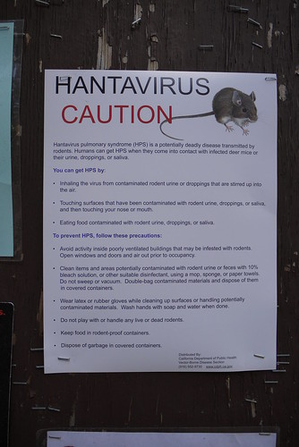
公園ゲートで配布されたCDCのパンフレット


2012年06月13日
White Wolf Campground is now open
White Wolf Campground is now open. (M. Carter)
_________________________________________
More DNC Openings
White Wolf Lodge is now open for the 2012 summer. Wawona and Tuolumne Stables are
now open for the 2012 summer. (W. Kearns)
2012年05月30日
ハーフドーム頂上のワイヤーケーブルが設置
ハーフドーム頂上のワイヤーケーブルが25日(金)から設置され、今シーズンの登頂が可能になっています。事前に予約が必要です。
http://www.nps.gov/yose/parknews/hdcablesup2012.htm
2012年05月16日
2012年05月14日
HDトレイルOpenは5月25日の予定
The Half Dome cables are down for the season. The cables are scheduled to be ready for use on May 25, 2012 (conditions permitting). Permits will be required seven days per week to hike to the top of Half Dome in summer 2012.
2012年05月08日
Tioga Road開通
今年1月17日に閉鎖してから、わずか4ヶ月弱後に開通という、記録破りの短い冬でした。
The Tioga Road opened for the season on Monday, May 7, at noon.
http://www.nps.gov/yose/planyourvisit/tiogaopen.htm
2012年05月03日
Tioga Rd. 7日開通予定
Tioga Road (Hwy 120 through the park) is closed
The Tioga Road (Highway 120 through the park from Crane Flat to Tioga Pass) is closed due to snow. It will open for the season on Monday, May 7 at noon. (Yosemite Valley is accessible via Highway 120 from the west.)
2012年04月27日
Tioga Rd.除雪完了、残すは修理保全作業。
この道路作業は、通常1~2週間程度かかります。ので、5月5日と11日の間に開通と思われます。
今年は雪が少なかったこともあり、5月5日の可能性が高そうです。
Last update: April 26, 2012
Tioga Road: The Tioga Road has been plowed, but much work remains, including significant road repairs and rock removal, along with plowing of parking lots, side roads, and clearing of ditches. There is no estimated opening date for the Tioga Road.
2012年04月24日
Tioga Rd.除雪、Olmsted Pt.に到達
Tioga Rd.除雪、Olmsted Pt.に到達。
昨日一日で、Yosemite CreekからOlmsted Pt.間を除雪したことになります。
今週後半天気が崩れますが、金曜にTM到達の可能性がありそうです。
Last update: April 23, 2012
Tioga Road: Plows have reached Olmsted Point and crews will assess the avalanche zone tomorrow.
Despite the below-average snowpack, full avalanche precautions are still in place.
2012年04月21日
Tioga Rd. 除雪、Yosemite Creekに到達
一週間で、ヨセミテCreekに到達してしまいました。
今年の開通は5月4~11の間の雰囲気です。
Tioga and Glacier Point Roads Plowing Update
Tioga Road: Plows have reached Yosemite Creek and are seeing below-average snow amounts. Snow depths are up to three to five feet. Despite the below-average snowpack, full avalanche precautions are still in place.
There is no estimated opening date for the Tioga Road.
2012年04月20日
Glacier Point Road明日 開通予定
Date: April 19, 2012
http://www.nps.gov/yose/parknews/gpopen12.htm
The Glacier Point Road in Yosemite National Park will open for the season on tomorrow, Friday, April 20, at 5:00 p.m. There will be limited visitor services available at Glacier Point. Vault toilets will be available, and there will be no running water. There is no projected opening date for the Bridalveil Creek Campground.
The roadway may be wet due to melting snow and wildlife may be present on or near the road. Visitors are urged to drive with caution while in the park. The Glacier Point Road is subject to unexpected and temporary closures due to unpredictable spring storms that may produce snow at the higher elevations of the park.
Due to snow, ice, and avalanche conditions, the Tioga Road will remain closed. There is no projected opening date for the Tioga Road at this time.
今期の冬は、Tioga Roadのクローズで記録を作りましたが、GP Rd.の開通日でも記録を作りそうです(ほぼ確定)。
http://www.nps.gov/yose/planyourvisit/tiogaopen.htm
2012年03月25日
Above Yosemite and Mono Lake
友人のBethがフライトの上空から、3/19の雪化粧のヨセミテを撮った写真を解説付きで掲載しています。素晴らしいです。
http://www.bethpratt.com/up-and-down-california/2012/3/24/above-yosemite-and-mono-lake.html
2012年02月17日
2012年01月15日
2012年シーズンのハーフドーム登頂の許可情報
2012年シーズンのハーフドーム登頂の許可情報が出ました。
シーズン前と、シーズン中に抽選で決定する仕組みになるようです。
詳細はWEBで、(とりいそぎ英語)
http://www.nps.gov/yose/parknews/hdpermits5.htm
http://www.nps.gov/yose/planyourvisit/hdpermits.htm
2011年06月10日
キャンプ場予約システムについての変更
園内のキャンプ場予約に関しての変更が3点通知されています。
1.6/8以降、チェックインの際にIDカードの提示しての本人確認が求められる。(予約した名義とチェックイン本人との照合の厳密化)
2.6/8以降、一旦予約した氏名を変更することはできない。(一旦キャンセルし、新規に別の名前で予約する必要)
3.キャンセル分の予約は、オンライン・システムでは公開されず、電話でのみ予約が可能となる。(夏シーズン後半以降に適用)
原文はこちらです。
Yosemite National Park Announces Changes to the Campground Reservation System
http://www.nps.gov/yose/parknews/recgovchanges.htm
2011年05月23日
Tioga Pass情報(Lee Vining側)
タイオガパスの開通情報がウェブサイトによってごっちゃになっていて、開いているはずと思い込んでやってくる観光客の人が多くなってきたので、正しい情報をと思いまして。。。
モービルから4マイルほどの下ゲートですが、ここも開いてません。
モノカウンティが行う除雪は公園内まで入っていますが、雪解けによる落石や雪崩の危険性が高いので、一般には開けられないというのが理由だそうです。
多分来週中は天気が良さそうなので、ここ1週間で下のゲートは開きそうな気配です。
マンモスマウンテンのスキー場がスノーキャットを送り込んで除雪頑張ってるそうなので、6月も2週目までには開くだろうというのが予想です。
ゲートからは徒歩やバイクなら歩いてパスを上がれます。車がこないので最高です!!
通常ソノラパスが89の次に開きます。R4も間もなく開くでしょう。
ソノラはとても雪の多い年でも、メモリアルウィークエンド前後には開く事が多いです。今年もその気配。。。
ちなみにリーバイニングからソノラパスを通ってヨセミテバレーへは、6時間くらいでしょうか。
BBSの欄に書き込みがあったハッシーさんに返信させて頂きましたけど、かなり遅いので見られないでしょうねぇ。。
下ゲートが開いたら公園入り口までいけますので、そしたらまたご連絡しますね!!