2005年09月 アーカイブ
- 2005年09月28日 Tuolumne Meadowsキャンプ場営業終了
- 2005年09月27日 ハーフドーム・トレイル工事
- 2005年09月25日 Remembered Yesterdays
- 2005年09月24日 Sierra Stove
- 2005年09月23日 Time and the Tuolumne Landscape
- 2005年09月22日 Sugar Pine
- 2005年09月21日 Wilderness Permit Station
- 2005年09月20日 Gas
- 2005年09月19日 Full Moon
- 2005年09月18日 White Wolfキャンプ場営業終了
- 2005年09月18日 Forest Service: 火事情報Web.
- 2005年09月17日 Cantrans: 道路状況Web.
- 2005年09月16日 Climber Falls from Half Dome
- 2005年09月16日 The Range of Light
- 2005年09月15日 Smoky Jack Dome
- 2005年09月14日 シーズン営業終了 - Happy Isles Nature Center
- 2005年09月14日 Blaze
- 2005年09月13日 Puppy Dome & Kitty Dome
- 2005年09月12日 nanae@sierra
- 2005年09月11日 Wilderness Use Permit
- 2005年09月10日 Online History Books
- 2005年09月09日 4歳児の快挙
- 2005年09月09日 Mono Pass & Bloody Canyon
- 2005年09月07日 営業終了
- 2005年09月06日 Red bear
- 2005年09月06日 GAS price
- 2005年09月05日 オバタ・レイク
- 2005年09月04日 NPSインタープリテーション
- 2005年09月03日 DVD: The Greatest Good
- 2005年09月02日 ヨセミテで使える携帯電話はどれだ!?【考察】
- 2005年09月01日 ル・コンテ記念館
2005年09月28日
Tuolumne Meadowsキャンプ場営業終了
Tuolumne Meadowsキャンプ場が先週末で今シーズンの営業を終了しました。またWawonaのキャンプ場は当日先着順受付となっています。
いよいよハイカントリーはシーズンオフが近づいてきました。寂しいですね。
Tuolumne Meadows Campground has closed for the season.ハ Wawona Campground is now first-come first-served. (M. Carter - 9/26/05)
2005年09月27日
ハーフドーム・トレイル工事
NPSによるとハーフドーム・トレイル(サブドーム部分)の工事は予定より早く9/29の午後4時に完了します。その後10/10まで制限なしで通行可能です。そして10/11に頂上ワイヤーケーブルが外され(天候による)、オフシーズンとなる予定です。
Half Dome Cables - The work to repair the Sub Dome segment of the Half Dome Trail will be completed at 4 pm on Thursday, September 29, 2005. The Half Dome trail will be open without restriction through Monday October 10, 2005. On Tuesday October 11 the cables are scheduled to be taken down for the winter, weather permitting. (S. Baudoux - 9/23/05)
2005年09月25日
Remembered Yesterdays
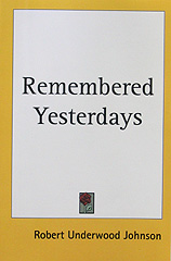
"One conversation that we had beside the campfire at Soda Springs had an important sequel, for it was here that I proposed to Muir that we should set on foot the project of the Yosemite National Park." Robert Underwood Johnson「Rembered Yesterdays」
ヨセミテ国立公園の設立運動や、Hetch Hetchy渓谷のダム化反対運動などに関わった、Century誌の編集員Robert Underwood Johnsonは、1923年に回顧録”Remembered Yesterdays”を出版しました。それには、1889年にSan Franciscoのホテルで初めてMuirに会ったとき、共にYosemiteに出向き、Tuolumne MeadowsのSoda Springsで、国立公園設立の運動をする提案をしたこと、1890年に連邦議会での公園設立運動に関わった政治家たちのこと、その後アメリカに広まった森林保護の流れやHetch Hetchy問題に絡む、Roosevelt大統領やPinchot(Forest Service初代長官)との書簡のやり取り、Roosevelt本人から聞いたMuirとのヨセミテ旅行のことなどが書かれています。600ページとかなり厚い本ですが、上記に関連した部分は50ページ程度しかなく、あまりお買い得感はありませんが、Muirの個性や当時のワシントンの内情がうかがえ、貴重なヨセミテ・Muir関連資料といえるでしょう。
タイトル:Remembered Yesterdays
著者:Robert Underwood Johnson
出版社:Kessinger Publishing
2005年09月24日
Sierra Stove
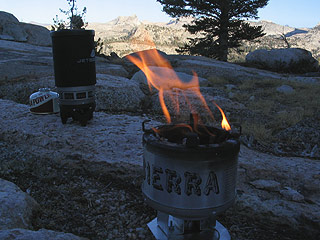
シエラストーブという、超小型の薪ストーブがあります。大きさは、丼程度のブリキ製で、底に単三電池一本で動くモーターで回るファンを取り付け、ふいごのように、下から風を送り、小枝などを燃やす仕組みになっています。買い物袋いっぱいの枯れ枝(太さは鉛筆以下が最適)があれば、数時間のミニ焚き火が楽しめます。ほぼ完全燃焼するので、煙も出ず、燃えカスの灰もほんのわずかしか出ません。Wildernessでの幕営地での焚き火は楽しいものですが、無制限にどこでもできるわけではありません(新しい竃を作れないなどのルールがあります)。このストーブならば、ほぼ自然にダメージを与えず、場所を選ばずに焚き火ができます。
2005年09月23日
Time and the Tuolumne Landscape
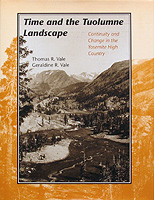
Tuolumne MedowsおよびHigh Sierra付近で1900年代初頭に撮られた写真(主にG. K. Gilbertが撮影)と、同じ撮影場所から80〜90年後に撮った写真の二つを並べ、地勢・植生・人為の影響(車道・ダム・建造物)を比べた写真集です。岩山等に変化は見られませんが、積雪量、植生、そしてメドウなどでの川の流れの違いにはかなり驚かされます。過去の写真と合わせるため、すべてモノクロが使われています。各写真の解説も読んでいて興味深いものがあります。
Time and the Tuolumne Landscape: Continuity and Change in the Yosemite High Country
Thomas R. Vale and Geraldine R. Vale著
総200ページ強
出版社: Univ of Utah Press
ISBN: 0874804299
2005年09月22日
Sugar Pine
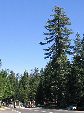
Of all the world’s eighty or ninety species of pine trees, the Sugar Pine (Pinus Lambertiana) is king, surpassing all others, not merely in size but in lordly beauty and majesty. - John Muir「The Yosemite」
巨大な松ぼっくり(コーン)をつけるSugar Pineの木は独特な形をしており、遠くからでも簡単に識別が可能です。120号沿いでは、特にBig Oak Flat EntranceとMerced Groveの間でかなりの数を見かけることができます。写真:Big Oak Flat Entranceにある巨大なSugar Pine。枝の先端にはコーンが付いています。
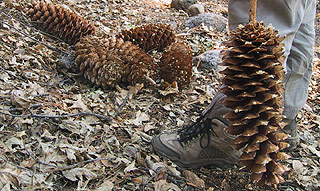
写真:トレイルに落ちていた中型のコーン。
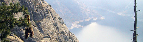
写真:Sugar Pineの枝の先端。
2005年09月21日
Wilderness Permit Station

Yosemiteウイルダネスに入るための許可証は、公園内にあるいくつかのオフィスで発行してくれます。コンピュータ内に名前、住所などが登録されるので、2度目以降は、名前・TH・日数・人数を言うだけで、すぐ作成・プリントしてくれます。そのとき食料の保管方法(熊対策)などルールについて突然質問される(ことがある)ので、事前に調べておきましょう[*]。写真はBig Oak Flat EntranceのWilderness Permit Station。
[*]初めてWilderness許可証を所得したとき、重いし見た目も悪いので、熊缶(Bear Canister)を持たずに行こうとしました。しかしRangerの質問でばれてしまい、荷物検査を含み、いろいろと教育的指導を受けてしまいました。もちろん熊缶は持たされました(以降必ず持ち歩いています)。
2005年09月20日
2005年09月19日
Full Moon
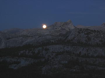
土曜の夜、月がCathedral Peakから上ってきたところです。撮影技術、カメラともにプアーで、まともな写真になっていませんが、とりあえず雰囲気だけ味わってください。撮影場所はTuolumne peakの南側。The Old Farmer’s AlmanacによるとEastern Timeで17日22時1分が満月とのことです。
2005年09月18日
White Wolfキャンプ場営業終了
White Wolfキャンプ場が今シーズンの営業を18日で終了しました。
---
White Wolf Campground will close for the season on 9/18. (M. Carter - 9/16/05)
Forest Service: 火事情報Web.
夏が終わると、マネジメントファイアを含めて山火事が増え、煙が公園内に入り込んできます。
このウエブでほ、全国のActive Fireの状況が報告されます。特にシエラネバダに関しては、こちらの地図が有用です。
2005年09月17日
2005年09月16日
Climber Falls from Half Dome
Half Domeの垂直面を登っていたロッククライマーが転落死したそうです。
今回はロッククライマーでしたが、みなさんもくれぐれもお気をつけて。
(私はこの土曜日(17日)に登りに行く予定です)
Yosemite National Park News Release
September 15, 2005
For Immediate Release
Climber Falls from Half Dome
A rock climber fell to his death while rock climbing in Yosemite National Park yesterday, September 14, 2005.
Bela Feher, 35, of San Diego, California, was rock climbing near the "Slab Route" on the face of Half Dome, when he apparently fell 100 to 150 feet. Park Rangers were notified when his body was discovered by other rock climbers at 11:00 A.M. yesterday. Feher had technical rock climbing gear and apparently was attempting to climb the face of Half Dome. He was climbing alone.
The exact cause of death and other details are pending investigation.
The Range of Light
"Then it seemed to me the Sierra should be called, not the Nevada or Snowy Range, but the Range of Light." John Muir
「Sierra Nevada」[英訳:The Snowy (Mountain) Range]という単語は、1776年、サンフランシスコ湾付近から、その山々を遠望したスペインの伝道師Pedro Fontによって、初めて地図に記されました。1890年、MuirはCentury誌に投稿した記事「The Treasures of The Yosemite」(8月号)の中で、自分にとっては「Sierra Navada」は「Snowy Range」ではなく「The Range of Light」と呼ぶべきだと書きました:Then it seemed to me the Sierra should be called, not the Nevada or Snowy Range, but the Range of Light[1]。 「The Range of Light」がMuirによる造語なのかどうかは定かではありませんが、このフレーズは、その後のMuirの著書「The Mountains of California」(1894年)、および「The Yosemite」(1912年)でも使われています[2][3]。本人によれば、「The Range of Light」という表現は、初めてヨセミテを訪れた1868年に、San Joseの南東Pacheco Pass(CA152号上)からSierra Nevadaを望んだときに思いついたと説明しています[註]。また1911年に出版された「My First Summer in the Sierra」[4]では、「The Range of Light」を使い、結びとしています:Here ends my forever memorable first High Sierra excursion. I have crossed the Range of Light, surely the brightest and best of all the Load has built; and rejoicing in its glory, I gladly, gratefully, hopefully pray I may see it again. 「The Range of Light」はもはや「Sierra Nevada」の代名詞です。ハイシエラで時を過ごすことにより、誰もが「The Range of Light」の表現のもつ奥深さを感じ取れることでしょう。
[1] The Tresures of The Yosemite(1890): One shining morning, at the head of the Pacheco Pass, a landscape was displayed that after all my wanderings still appears as the most divinely beautiful and sublime I have ever beheld. There at my feet lay the great central plain of California, level as a lake thirty or forty miles wide, four hundred long, one rich furred bed of golden Compositae. And along the eastern shore of this lake of gold rose the mighty Sierra, miles in height, in massive, tranquil grandeur, so gloriously colored and so radiant that it seemed not clothed with light, but wholly composed of it, like the wall of some celestial city. Along the top, and extending a good way down, was a rich pearl-gray belt of snow; then a belt of blue and dark purple, marking the extension of the forests; and stretching along the base of the range a broad belt of rose-purple, where lay the miners’ gold and the open foothill gardens?all the colors smoothly blending, making a wall of light clear as crystal and ineffably fine, yet firm as adamant. Then it seemed to me the Sierra should be called, not the Nevada or Snowy Range, but the Range of Light. And after ten years in the midst of it, rejoicing and wondering, seeing the glorious floods of light that fill it,?the sunbursts of morning among the mountain-peaks, the broad noonday radiance on the crystal rocks, the flush of the alpenglow, and the thousand dashing waterfalls with their marvelous abundance of irised spray,?it still seems to me a range of light. But no terrestrial beauty may endure forever. The glory of wildness has already departed from the great central plain. Its bloom is shed, and so in part is the bloom of the mountains. In Yosemite, even under the protection of the Government, all that is perishable is vanishing apace.
[2] The Mountains of California(1894): When I first enjoyed this superb view, one glowing April day, from the summit of the Pacheco Pass, the Central Valley, but little trampled or plowed as yet, was one furred, rich sheet of golden compositae, and the luminous wall of the mountains shone in all its glory. Then it seemed to me the Sierra should be called not the Nevada, or Snowy Range, but the Range of Light. And after ten years spent in the heart of it, rejoicing and wondering, bathing in its glorious floods of light, seeing the sunbursts of morning among the icy peaks, the noonday radiance on the trees and rocks and snow, the flush of the alpenglow, and a thousand dashing waterfalls with their marvelous abundance of irised spray, it still seems to me above all others the Range of Light, the most divinely beautiful of all the mountain-chains I have ever seen.
[3] The Yosemite(1912): Looking eastward from the summit of the Pacheco Pass one shining morning, a landscape was displayed that after all my wanderings still appears as the most beautiful I have ever beheld. At my feet lay the Great Central Valley of California, level and flowery, like a lake of pure sunshine, forty or fifty miles wide, five hundred miles long, one rich furred garden of yellow Compositoe. And from the eastern boundary of this vast golden flower-bed rose the mighty Sierra, miles in height, and so gloriously colored and so radiant, it seemed not clothed with light, but wholly composed of it, like the wall of some celestial city. Along the top and extending a good way down, was a rich pearl-gray belt of snow; below it a belt of blue and lark purple, marking the extension of the forests; and stretching long the base of the range a broad belt of rose-purple; all these colors, from the blue sky to the yellow valley smoothly blending as they do in a rainbow, making a wall of light ineffably fine. Then it seemed to me that the Sierra should be called, not the Nevada or Snowy Range, but the Range of Light. And after ten years of wandering and wondering in the heart of it, rejoicing in its glorious floods of light, the white beams of the morning streaming through the passes, the noonday radiance on the crystal rocks, the flush of the alpenglow, and the irised spray of countless waterfalls, it still seems above all others the Range of Light.
[註] Muirの最初のヨセミテ旅行(1868年)の記録は、Bade編のMuirの手紙集のVI章に引用されています。それにはPacheco Passからの記述はあるものの、「The Range of Light」という表現は使われていません。したがって、実際には文を書く都合上、「The Range of Light」を1868年に思いついた風に書いたと考えるのが妥当だと思われます。
[参考] 日本アルプスの登山黎明期に名をはせた小島鳥水(California在住11年)は、著作「高山の雪」(明治44年)のなかで、わずかながらMuirの「The Range of Light」について触れ、『米人ジョン・ミュ−アJohn Muirは、かってヨセミテ渓谷Yosemite Valleyの記を草して、このシエラ山はまったく光より成れる観があるといって、シエラをば「雪の峰と呼んではいけない、光の峰と名づけたほうがいい」と言ったが…』と書いています(岩波文庫、山岳紀行文集「日本アルプス」;小島鳥水著・近藤信行編;1995年第7刷;342ページより)。
2005年09月15日
Smoky Jack Dome
正式な名称ではなく、Smoky Jack (Campground) 近くのDomeと言った方が正確か。
Tioga Road(120号)沿い、T6:Smoky JackとT7:Red Fir Forestの間の道路北側にある花崗岩ドーム。
Valley側から来ると、最初に現れる岩の風景なので、
この道路を通った事があればなんとなくイメージできるのではないでしょうか。
オフィシャルな駐車スペースやトレイルはありませんが、
ピークまでは簡単に登ることが出来ます。数百メートルです。
しかし、登っても何があるわけでもなく、眺めが良いわけでもありません。
ドーム歩きの練習ぐらいでしょうか。
そういう目的であれば、Olmsted裏のdomeの方がよりベータ−なので、
登っている人を見た事はありません。物好きな人はどうぞ。
2005年09月14日
シーズン営業終了 - Happy Isles Nature Center
Happy Isles Nature Centerが11日の日曜で今シーズンの営業期間を終えて閉館となりました。
近年このセンターはY.A.のボランティアスタッフに運営が任されており、この夏シーズンの運営の中心だった2名のボランティアの名前を挙げて感謝の意をあらわしています。
Happy Isles Nature Center Seasonal Closure - The Happy Isles Nature Center closed for the season on Sunday, September 11, 2005. Please join me in thanking MaryJane Johnson, Dawn Sherertz, and the rest of the talented and resourceful YA volunteer crews who kept the HINC open for visitors to enjoy for another summer. This rich interpretive facility would not be available to the public without the YA volunteers' efforts. You are the best! (L.? Rematore/Yosemite Association - 9/13/05)
Blaze
ロッジポールの林の中のトレイルを歩いていると、木の表皮が削られた痕を見かけることがあります。これは、昔つけられた道しるべ(Blaze)です。人の頭の高さほどのところにあり、注意していると、かなりの数を見つけることができます。トレイルビルダー、軍、放牧、採掘業者たちによる、いろいろな形のBlazeがあったようです(詳しくはGreeneの324ページ付近)。
Greeneより一部転載:
A valuable group of resources within Yosemite National Park's backcountry are the blazes left by individuals who used the backcountry in a variety of ways. Styles range from the vertical lens of sheepherders Q to the uppercase T of the military to the more recent U.S. Forest Service I . "Some wags stoutly maintained that the 'T' was used as [the] symbol so that the Irishmen in the army would know that it was a tree!" Although the early sheepherder blazes marked trails and grazing areas, some figures and designs appear to be simply efforts to pass the time. The army used the T mark between 1890 and 1914, possibly ending as early as 1906, to aid backcountry patrols, especially after snowfalls. After that time Gabriel Sovulewski, in charge of trail work, used a diamond-shaped blaze, which was used into the 1930s until he retired.
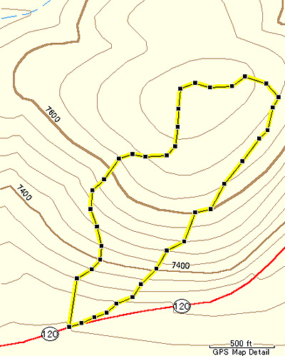
2005年09月13日
Puppy Dome & Kitty Dome
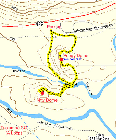
・Puppy Dome
Tioga RoadからTuolumne Lodgeへの分岐を曲がってすぐのところにあるとても小さなドーム。
そこにある駐車場からはすぐにアクセスできる。(非公式トレイル(図中の右ルート上半分)あり)
ドームの西壁はクライマーのメッカになっていて、こちら側ふもとにもクライマールートは多々あり、
Dana Forkまで簡単にアクセスできる。こちら側からの登頂も可能。(図中の右ルート下半分)
(北ルート:0.3mile、南ルート:0.4mile, 150ft)
・Kitty Dome
Dana Forkを挟んでPuppy Domeの南にあるとても小さなドーム。
各方面から登れるが、Puppy Dome側からが最も簡単。
Tuolumne CGのAループ端からJMT経由でも簡単にアクセス可能。
Dana ForkとLyell Forkに挟まれた陸地にあり、ベースへのアクセスはどちらかの渡渉が必要だが、
シーズン初めは川の水量が多いので濡れずに渡るのは困難。
(0.5mile, 150ft)
どちらのドームも周辺の他のドームや山に比べるととても小さいものの、
上に登るとそれなりの展望が利きます。
Lembert Dome中腹から見たPuppy Dome(左)とKitty Dome(右)。
Puppy Dome左手前が駐車場。
2005年09月12日
nanae@sierra
ヨセミテ国立公園の東側のエントランスのあるタイオガパスの麓の街Lee Viningにお住まいのnanaeさんから、ブログサイト開設のお知らせをいただきました。この街に住む日本人はnanaeさんお一人だけ。
昨年夏はなんとあの「モービルガスステーション」で働いておられたそうです。
nanaeさんのサイトは
「nanae@sierra」
です。
2005年09月11日
Wilderness Use Permit
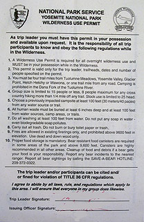
バックパッキングなどでWildernessにキャンプをする場合、Wilderness Use PermitやVisitor's Permit等と呼ばれる許可証の携行が義務づけられています。ヨセミテの場合、許可証は、公園内のWilderness Permit Stationで予約(60%)もしくは当日申請(40%)によって所得できます。許可証さえあれば、どこに行ってもよいというわけではなく、入出日、入るトレイルヘッド(TH)、出るTH、メンバー数などが厳しく制限されています。特にヨセミテの場合、各トレイルから一日に入れる人数が制限されており(Quota制度)、人気コースのTHは、予約分がすぐ、なくなってしまうことがあります。許可証にはグループの最大人数、水場からキャンプ地までの距離、Valley, Tuolumne Meadowsなどの混雑したところからの最低距離、焚き火は既にかまどのできているところでのみする、などのWildernessで守らなければならないルールが記載されています(続きに原文を抽出)。許可証(2003年版[註])下部には太文字で、「規則違反者は召喚・罰金の対象となる」と書かれており、その下には「上記の法やルールを守り、メンバーもそれに従わせることを約束します」と続き、その下に同意のサインをすることになります。
Yosemite Wilderness利用の手続き、予約状況に関しては、ヨセミテ国立公園WebのYosemite Wildernessページに書いてあります。また許可証は年度によって形式が異なっています。
[註]2005年版Permitの内容も、まったく同じです (2005-Sep-18)。
Wildernessでのルール
1. A Wilderness Use Permit is required for all overnight wilderness use and MUST be in your posession while in the Wilderness
2. This permit is valid only for the trip leader, trailheads, dates and number of people specified on the permit.
3. You must be four trail miles from Tuolumne Meadopws, Yosemite Valley, Glacier Point, Hetch Hetchy or Wawona, or one mile from any road. Camping is prohibited in the Dana Fork of the Tuolumne River.
4. Group size is limited to 15 people or less, 8 people maximum for any cross country hiking more than 1/4 mile off any trail. Stock use is limited to 25 head.
5. Choose a previously impacted campsite at least 100 feet(30 meters/40 paces from any water source or trail.
6. All human waste must be buried at least 6 inches deep and at least 100 feet from any water source or trails.
7. Do all washing at least 100 feet from water. Do not put any soap in water even biodegradable soap pollutes.
8. Carry out all trash. Do not burn or bury toilet paper or trash.
9. Fires are allowed in existing firerings only, and prohibited above 9,600 ft. in evelation. use dead and down wood only.
10. Proper food storage is mandatory. Bear resistant food canisters are required in some areas of the park and above 9,600 feet. Canisters are highly recommended in all other areas. Cleanup of food and debris if a bear gets your food is your responsibility. Report any bear incidents to the nearrest ranger. Report all bear sightings by calling the SAVE-A-BEAR HOTLINE: 209-372-0322
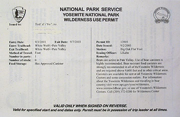
許可証の表側:名前・住所の下にEntry Data, Entry Trailheadなどが記載されている。Wildernessの使用状況はコンピュータで管理されている。
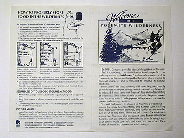
別に渡される、Wildernessルールを書いた紙(表側)。左側に、熊に対する食料保管のしかたが詳しく書かれている(これは昔から使われている)。
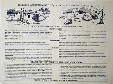
裏側:Wildernessでのルールが書かれている。
2005年09月10日
Online History Books
NPSのHistory Webサイトからは、NPS関連のかなりの書籍がDownloadできます。特にヨセミテに関連したものはこちらにあります。
また、Dan Anderson氏のOnline Historical Yosemite Books サイトも必見です。氏には、Yosemite.jpからのリンクを快諾していただきました。
2005年09月09日
4歳児の快挙
先日のレイバーデイウイークエンドにすやまさん一家がシエラ東方の山、White Mountain(14,250feet=4,343m)に登られました。4,343mですよ。
この山の登山道を管理している(ということでいいのかな)カリフォルニア州立大学の研究機関のページでなんと「 including 4 year old Tomo Suyama who walked all the way! 」として紹介されています。写真入りです。
まあ、先日のJohnson Peakでも「4歳児の快挙」だっったのですが。
“OPEN GATE DAY” was hosted on Sunday, September 4, between 7 am and 6 pm. Hikers wishing to climb White Mountain Peak were allowed to drive to the Barcroft Station to begin their ascent. Over 100 people participated, including 4 year old Tomo Suyama who walked all the way! (see center of photo) Our Annual Open House was hosted at Barcroft Sunday August 7, 2005. Details on web page, including photos of hailstorm.
Mono Pass & Bloody Canyon
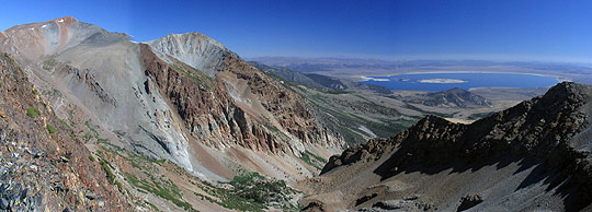
「The trail comes down three thousand feet in less than four miles, over rocks and loose stones, in narrow canyons and along by precipices. It was a bold man who first took a horse up there. The horses were so cut by sharp rocks that they named it "Bloody Canyon," and it has held the name?and it is appropriate?part of the way the rocks in the trail are literally sprinkled with blood from the animals.」 William H. Brewer, July 7th 1863
Tioga Passの公園入り口から南に1.5マイルほど行ったところに、Mono PassへのTHがあります。ここから高度差1,000ft.強、長さ4マイルほどのトレイルを進むと、峠(Mono Pass: 標高約10,600ft.)に達します。昔、インディアンたちはこの峠を使い、シエラ越えをしていました。すぐ南にあるMt. Lewisの方に登ると、Bloody CanyonとMono Lakeがよく見えます(写真)。California Geological SurveyのBrewerは、まさに名前のとおり、馬などが足を傷つけ、流れ出た血が、岩についていたと書いています。
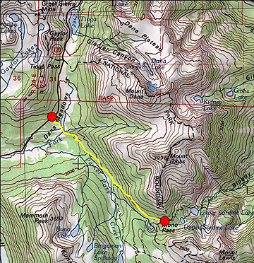
左の赤丸がTH。Mono Passは南東方面(右の赤丸)。
2005年09月07日
営業終了
レイバーデイウィークエンドが終わり、Tamarack Flat、Bridalveil Creek、Yosemite Creekのキャンプ場は9月5日をもって今シーズンの営業を終了しました。
---
Campground closures: Tamarack Flat Campground, Bridalveil Creek Campground, and Yosemite Creek Campground will close for the season on Monday September 5th. (M. Carter - 9/06/05)
2005年09月06日
Red bear
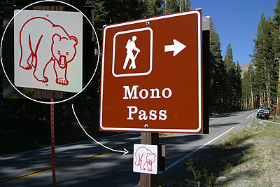
土曜日(9/3)にTioga Pass Rdを車で走っていたら、
所々で赤いクマの絵のマークのサインを目にしました。
先週は見た記憶がありません。
これは何だろう?と思っていたら、
Tioga Passのエントランスステーションに説明が張り紙されていました。
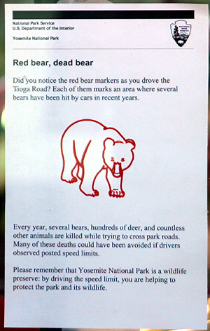
少なくとも以下の場所にはありました。
もっとあったような気がしていたのですが発見できませんでした。
T1 Tuolumne Grove
T4 view point
T10 Yosemite Creek Camp分岐
T15 Yosemite Creek
T17 Porcupine Flat
T35 Dana Meadow
T37 Mono Pass
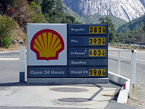
GAS price
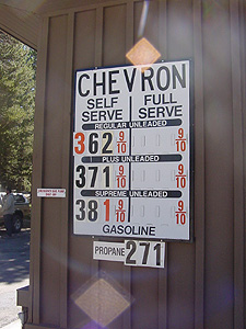
9/5のTuolumne Meadows GSのGas Price
他にも同じように写真を撮っている人がいて、
立ち話に花が咲いてしまいました。
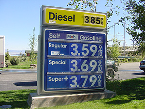
こちらはTioga Gas Mart
先週のハリケーン以降GAS価格が急騰してます。
2005年09月05日
オバタ・レイク
Obata Lake
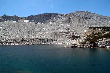
先日のJohnson Peak登頂のハイキングで、密かに楽しみにしていたのが「オバタ・レイク」です。
Tuolumne Meadowsの南方、Johnson Peakの麓には無名の湖が2つありますが、そのうち奥の湖が関係者の間で「オバタ・レイク」と呼ばれています。チウラ・オバタ(小圃千浦)が1930年に描いた「Lake Basin in High Sierra」の湖がこの湖だといわれています。
この絵はY.A.の発行する「Obata's Yosemite」にも掲載されています。
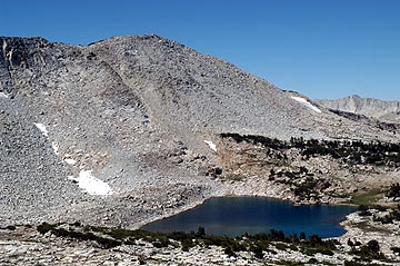
Johnson Peakトレイル途中からの眺めです。
2005年09月04日
NPSインタープリテーション
NPSのウエブサイトに行くと、4つのトピックがあります。そのうちの一つ「Interpretation & Education」には、NPSが重視しているInterpretation(インタープリテーション)という活動の説明があり、それは訪問者が公園(place)での思い出などを作る手助けの過程であり:”In the National Park Service, Interpretation is the process of helping each park visitor to find an opportunity to personally connect with a place.”、その目的は、訪問者の楽しみや公園の理解をさらに高め、公園に関心を持つようにする:”The goal of all interpretive services is to increase each visitor's enjoyment and understanding of the parks, and to allow visitors to care about the parks on their own terms."といったことが書かれています。インタープリテーションの詳しい講義は専門の西村さんに譲り、ここではNPSの職員がどのようにしてその技術を身につけるのかを調べてみました。1995年から開発されたIDPと呼ばれるシステムがあり、3段階のレベルに分かれた教材が作成されています。一般のレンジャー(Law Enforcementも含む)には、初期レベルの技能習得が勧められており、それには3つの教材(101,102,103)があります。101はNPSでのインタープリテーションの基礎概念、102は略式での訪問者へのコンタクト、103は効率的な話し方となっています(全ての教材はダウンロードが可能)。またパークガイド(GS-0090)、アシスタント(GS-0303)、研修生、ボランティアにも習得が推薦されています。教材を読んでみると、単なる知識だけではなく、それをうまく訪問者に伝えるための、高度な対話技術が要求されているようです。
註:連邦政府の規定によると、Park Rangerとは職種GS-0025であり、以下のように定義されています。
GS-0025 - Park Ranger Series
This series includes positions the duties of which are to supervise, manage, and/or perform work in the conservation and use of Federal park resources. This involves functions such as park conservation; natural, historical, and cultural resource management; and the development and operation of interpretive and recreational programs for the benefit of the visiting public. Duties characteristically include assignments such as: forest and structural fire control; protection of property from natural or visitor related depredation; dissemination to visitors of general, historical, or scientific information; folk-art and craft demonstration; control of traffic and visitor use of facilities; enforcement of laws and regulations; investigation of violations, complaints, trespass/encroachment, and accidents; search and rescue missions; and management activities related to resources such as wildlife, lakeshores, seashores, forests, historic buildings, battlefields, archeological properties, and recreation areas.
その他の職種:
GS-0090 - Guide Series
This series includes all classes of positions the duties of which are to provide or supervise nonprofessional interpretive and guide services to visitors to parks, dams and other sites of public interest. The work involves giving formal talks, interpreting natural and historic features, explaining engineering structures and related water resource developments, answering questions, guiding tours, and providing miscellaneous services to visitors. Incidental duties are performed in connection with responsibility for visitor safety and protection of historic and scientific objects and natural or engineering features.
GS-0303 - Miscellaneous Clerk and Assistant Series
This series includes positions the duties of which are to perform or supervise clerical, assistant, or technician work for which no other series is appropriate. The work requires knowledge of the procedures and techniques involved in carrying out the work of an organization and involves application of procedures and practices within the framework of established guidelines.
2005年09月03日
DVD: The Greatest Good
“…where conflicting interests must be reconciled, the question will always be decided from the standpoint of the greatest good of the greatest number in the long run.” Gifford Pinchot, Chief Forester, 1905
今年設立100年を迎えたUSDA Forest Service(FS)が作成した、3枚組のドキュメンタリーDVDセット(120分の本編ディスク+2枚のボーナスディスク付き)。1800年代半ば、開拓と共にアメリカから森林が失われていくときから始まり、1905年、Gifford Pinchotを初代長官とするForest Serviceが設立されるまでの経緯、その後100年にわたる、さまざまな森林管理に関する問題:森林火災、車の普及に伴うレクリエーションの増加、伐採、Wilderness Actに始まる自然保護、そしてエコシステムの理解が進むことにより変わりつつある管理方針など、を時代を追ってわかりやすくまとめている。勿論Hetch Hetchy問題に絡むMuirとPinchotの確執、National Park Service(NPS)とFSのライバル関係などにも触れられている。自画自賛に陥ることなく、批判も含めて冷静に歴史を書いた作品となっている。リージョンコードなし、英文サブタイトル付き。
本編ディスクは4部構成、以下のトピックを繋いで作られている。
Part I − The Fight for Conservation: 1864−1910
1. A Wooden Nation
2. The Pinchot Family
3. Land Grants and Frauds
4. The Division of Forestry
5. President Theodore Roosevelt
6. The Birth of the Forest Service
7. Elers Koch and Early Rangers
8. Grazing
9. Midnight Forests
10. Denver Lands Convention
11. Hetch Hetchy
12. Pinchot, You’re Fired
Part II − Building the System : 1911−1940
1. The Big Blowup
2. Early firefighters and Lookouts
3. The Weeks Act
4. Motor Tourism and Trappers Lake
5. Aldo Leopold
6. The Dust Bowl and FDR
7. Civilian Conservation Corps
8. The Shack
9. Bob Marshall
10. 10:00 AM Policy and Smokechasers
Part III − Boom! : 1941−1970
1. World War II
2. America Needs Homes
3. The Forest Service Family
4. A Woman’s Role
5. Hot Shots and Tragedy Fires
6. Smokey Bear
7. The “Can Do” Agency
8. America’s Playground
9. Multiple Use
10. Timber is King
11. The Wilderness Act
12. Protest and Transformation
Part IV − The Greatest Good? : 1971−2005
1. Monongahela and Bitterroot
2. Environmental Laws
3. New Voices and Values
4. Roadless Area Review
5. Mount St. Helens
6. Old Growth, New Forestry
7. Fire versus Fire
8. People Pressures
9. Finding the Greatest Good
追記:個人的にはかなりお勧めのDVD。11年後にはNPSが設立百周年(1916-)を迎えます、どんな記念DVDが作られるのか今から楽しみです。
2005年09月02日
ヨセミテで使える携帯電話はどれだ!?【考察】
7-ELEVENで購入した"SpeakOut"のNOKIA1100
今回(2005.8/21-31)のアメリカ行き+ヨセミテキャンプには携帯電話を持参することにした。
通常日本ではNTTドコモのFOMAを使っているので、「WORLD WING」のサービスを使って、海外対応機種をレンタルして渡米すれば、いつもの番号、そしてiモードのメールなども利用可能である。ところが通話料金がバカ高いこと+レンタル料がかかり、おまけに海外渡航を知らない知人等からの電話が夜中にかかってきたりすればたまらない。ということで、渡米後に現地のプリペイド携帯を購入したほうがお得という結論に達した。
そこで渡米前にWEBでいろいろしらべてみると、、、、
1.FOMAに入っているSIMカード(FOMAカード)をGSM形式の電話機に差し替えると、いつもの番号で海外で使える。(ただしSIMロックがかかった電話機はダメ。)
2.アメリカではプリペイド携帯を各社が出している。年に2〜3回という渡米頻度では、これが適当か?
3.コンビニの7-ELEVENで買えるプリペイド携帯"SpeakOut"は電話機代、電話代ともに安く、また起動してから365日は電話番号や事前に支払った電話代が有効。(他社はもっと短い。)おまけにSIMロックはかかっていないというウワサ。
4.日本の携帯各社は「世界で使える。アメリカで使える。」と自社の国際ローミングサービスをアピールしているが、それをそのまま信じてはいけない。各社の電波カバーエリア図を見てみると、会社によってカバーエリアにはかなり差がある。広大なアメリカ大陸なので、人口の集中する都市部やメジャーなハイウェイ沿いにはアンテナが整備されていても、ヨセミテのように観光地とウィルダネスの隣り合ったところではいったいどうなっているのだろう。
5.Mountain Wireless - Cellular Sites in National Parks and Related Areasというページを見つけた。いつの時点の情報かわからないが、ヨセミテ国立公園内には8つの携帯電話アンテナが設置されていて、Verizon、AT&T(現在はCingular)、"Golden State Cellular"の3社によるもの。
Verizonはたぶんヴァレーをカバーする1ヶ所。
AT&T(Cingular)もたぶんヴァレーをカバーする2ヶ所。
地元の事業者Golden State Cellularのアンテナが一番多く、ヴァレー2ヶ所の他にワワナ、クレーンフラット、Tuolumne Meadowsの5ヶ所にあるようだ。ただWEBサイトを見てもローミング先などが分からず、自社のほかいったいどの会社の携帯電話で使えるのかは分からない。
6.Toshiさんからは「Verizon(CDMA)でしたが、TMM内及びそこが見えるところならば大体使えました。山陰に入るともうだめでしたね。携帯にはアナログモードが付いており(確かFCCにより義務化)、TMではアナログモードでつながっていたと思います。BOFのゲートでは電波が弱くて使えませんでした。バレーもアナログだったような…以上Verizonで1〜2年前の話です。」という情報をいただいていた。
ということで、今回のキャンプ地Tuolumne Meadowsは無理でもとりあえずヴァレーで使えればということで7-ELEVENの"Speak Out"を購入することとし、渡米初日にサンフランシスコそしてBerkeleyで7-ELEVENの各店を回り、Berkeleyの7-ELEVENでNOKIA1100という機種60ドル(通話料10ドル分付)と電話代25ドル分のカードを購入した。ということで、510-XXX-XXXXというBerkeley在住者のような番号の持ち主になったのである。
機種や在庫はあまり選択の余地がなく、店によっては取り扱いのない店舗もあった。
ところでこの7-ELEVENの"SpeakOut"であるが、自社で回線網をもっているわけではなく、Cingular(旧AT&T)のGSM回線網を借用してのサービスらしい。
(持参した日本の携帯からSIMカードを抜いてこの電話機に挿すと、みごとにNTT Docomoの文字が画面に現れて起動し、いつもの番号で着信もした。つまりウワサ通りSIMフリー!)
さて、この携帯をヨセミテに持参したわけだが、ベイエリアではもちろん問題なし。ハイウエイの道中も電波が入感していた。Oakdaleは◎、GrovelandもOKだったか。
ただしヨセミテに入園してからはまったく×となり、Tuolumne Meadowsも×。日程途中でヨセミテヴァレーに降りたのだがなんとここでも×だった。同行者がNTT Docomoでレンタルした「WORLD WING」の携帯N900iGを持ってきていたがこれも同様に×。つまりドコモもCingularのGSM回線網を使うので、同じというわけだ。以前得ていたCingularのアンテナ情報はGSMではなかったのである。
別の同行者がAUのGlobal Passport対応機種を持っていたが、これはヴァレーでは◎であった。(これはSprint PCSのローミングらしい。)
別の日にタイオガパスを越えてLee Viningの町にはいると、電話機に「Other Network(つまり他社ローミング)」の文字が現れて使用可能となった。ボイスメール(留守電)に1件メッセージが入っており、それを聴くのになにやら登録が必要で、またあたふたする。
ということでTuolumne Meadowsでは仕方なくキャンプ場事務所前の公衆電話で連絡をとっていたのだが、電話中の私の目の前で一人のオッサンが携帯電話でしゃべっているのを見かけたのである。終わったのを見計らって声をかけ、携帯電話をみせてもらった。画面にはなんと「Cingular」の文字、電話機はAT&Tとなっているではないか。しかしこれはたぶんCingularでもGSM形式ではなく、前世代のTDMAもしくはAMPS(アナログ)ではないかと思う。つまりこれと同じ電話機を入手するのはいまとなっては難しい。
キャンプを終え、SFに戻ってVerisonのお店でプリペイド携帯"inpulse"のパンフをもらってきた。カリフォルニア州の電波カバー図をみてみるとヨセミテヴァレー周辺および120号線沿線がローミングエリアに入っている(ように見える)。これはたぶんGolden State Cellularのアンテナだ。
また帰国してからまたWebを調べてみるとSan Francisco Bay Area Outlying Coverageというページで「Tuolumne county is covered by Golden State Cellular, a CDMA and AMPS provider. Verizon will roam onto Golden State Cellular. Not sure if AT&T TDMA/AMPS phones will roam onto Golden State Cellular's AMPS network (last time I tried it was January 2001 and it did not work).」という記述があった。(情報はすこし古いが…。)
おなじくこのページでは、作者は
「私のホームエリアを飛び出したときの私にとっての(どの携帯電話キャリアを選ぶかという)判断基準は、タルキートナ(アラスカ・デナリ山麓の町)で使えるか。ヨセミテとイエローストーンでおしゃべりできるか?」なのだという前提で、
AT&T TDMA/AMPS: Yes
AT&T GSM: No
Cingular TDMA/AMPS: Yes
Cingular GSM: No
Nextel iDEN: No
Sprint PCS CDMA/AMPS: Yes
T-Mobile GSM: No
Verizon CDMA/AMPS: Yes」
という結論を示している。というわけで次回(来年)はVerizon CDMAのプリペイド携帯を購入してヨセミテでの電波状況を見てきたいと思う。
(「イリジウム衛星携帯電話」なんていう無敵の存在もあるが。)
皆様のほうでも、情報がありましたらお寄せください。
■参考リンク
「IT Media - 米コンビニでプリペイド携帯を買ってみた」
「国際電話の達人」
「Oh my UA!」
2005年09月01日
ル・コンテ記念館
Le Conte Memorial Lodge
ル・コンテ記念館は創設期のシエラクラブの活動に貢献し、1901年にヨセミテヴァレーで亡くなった地質学者ジョセフ・ル・コンテを記念して1903年につくられました。チューダー朝デザインの花崗岩+木造の建物です。
当時はまだ国立公園の制度が十分に整っていない時代ですので、この建物でのシエラクラブの活動は実質的にビジターセンターの役割を果たしました。現在もこの建物はシエラクラブのボランティア達によって管理されライブラリ、子どものコーナー、歴史についての展示が整えられ、そして講演などの活動が行われています。
写真家のアンセルアダムスもかつて若い頃、ル・コンテ記念館の管理人として活動していました。
この建物は1987年にNational Historic Landmarkとして指定されています。
ここのボランティアの人たち(シエラクラブ会員)は皆優しくビジターを迎えてくれます。NPSのビジターセンターと違って混雑していませんので、彼らとのおしゃべりを楽しむことができます。
開館時間:5月〜9月の水曜日〜日曜日、午前10時〜4時
場所:ハウスキーピングキャンプの向かい側。ヴァレーシャトルバスで行くことができます。
シエラクラブ「ル・コンテ記念館」のページへ
http://www.sierraclub.org/education/leconte/