2009年05月 アーカイブ
- 2009年05月29日 金曜12時、TMグローサリーストア開業予定
- 2009年05月28日 SFクロニコル紙記事「CAMPING / Pack car, pitch tent, make room for lifelong memories」
- 2009年05月24日 ヨセミテ 5月23日
- 2009年05月20日 Tioga Road 20日10時に開通
- 2009年05月17日 ヨセミテ 5月16日
- 2009年05月16日 Half Dome トレイル オープン
- 2009年05月15日 CA108 (Sonora Pass) Open
- 2009年05月14日 Bicycles on Tioga Road
- 2009年05月12日 YNPの秘密兵器?
- 2009年05月10日 ヨセミテ 5月9日
- 2009年05月09日 Mariposa Groveトラムツアー運行開始
- 2009年05月08日 Tioga Road除雪状況 (5/6)
- 2009年05月07日 Valley内交通規制解除
- 2009年05月06日 Clark Pt. ? Nevada Fall間のJMT開通
- 2009年05月06日 GP Road開通
- 2009年05月04日 ヨセミテ 5月3日
2009年05月29日
金曜12時、TMグローサリーストア開業予定
The Tuolumne Meadows Grocery store will open at Noon on Friday, May 29, 2009, closing at 5 pm. The hours of operation from May 30 until June 30, 2009 are 8 am - 5 pm daily. Please drive carefully and be Bear aware while enjoying your drive to Tuolumne Meadows. DNC Retail Division. (V. McMichael - 5/28/09)
2009年05月28日
SFクロニコル紙記事「CAMPING / Pack car, pitch tent, make room for lifelong memories」
Tom StienstraによるSFクロニコル紙記事「CAMPING / Pack car, pitch tent, make room for lifelong memories」が掲載されています。
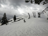
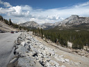
2009年05月24日
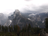
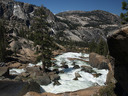
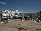
ヨセミテ 5月23日
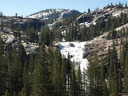
Olmsted Point付近。Tenaya Lakeの雪は完全に融けています。日当たりの悪い岩壁、樹林帯にはかなり雪が残っています(午後撮影)。
Pothole Dome付近から望むTuolumne Meadows一帯(午後撮影)。Medowsはかなり湿っています。
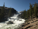
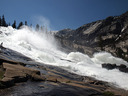
現時点でのTuolumneの水量はかなり多めです。これはTuolumne Falls。
White Cascade。上に見えているのはTuolumne Falls。
このすぐ左側にGlen Aulin HSCがあります。
今日一日で、5?6組のバックパッカーパーティを確認。
上の写真を撮った場所から反対側(西向き)にはGlen Aulinの谷が広がります。
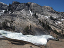
Glen Aulinの西端にあるCalfornia Falls。直前のトレイル(約100メートル)は水の下。サンダル持参をおすすめ。
Calfirnia FallsとLe Conte Fallsの間の無名の滝。
Waterwheel Fall。
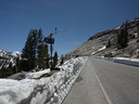
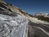
2009年05月20日
Tioga Road 20日10時に開通
Tioga Road沿いの施設が開くのには、あと数週間かかりそうです。
Tioga Road to Open in Yosemite National Park
Visitors urged to take safety precautions for upcoming Memorial Day Weekend
Yosemite National Park Acting Superintendent Dave Uberauga announced today that the Tioga Road will open for the season on Wednesday, May 20 at 10:00 a.m. for all vehicle traffic. The Tioga Road, bounded on both sides by State Highway 120, is the popular east-west crossing of the Sierra Nevada. There will be no commercial services available along the road until further notice. However, there will be gasoline available 24 hours per day (credit cards only). Additionally, the Tuolumne Meadows Campground, other campgrounds along the corridor, and the Tuolumne Visitor Center will not be open. There will be pit toilets available along the Tioga Road. All visitor services, including the campgrounds, store, gas station, etc. will open over the next several weeks.
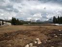
2009年05月17日
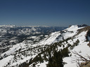
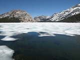
ヨセミテ 5月16日
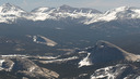
Tioga Roadの開通が目前に迫ってきました。そこで遠望ですが、Tuolumne Medowsのプレビュー。
奥の山は左から、Dana,、Gibbs、Mammoth Peak。Danaの45度右下に見えるのはLembert Dome。
Mammoth Peakの下はFairview Dome。Fairviewの左側にはTioga Roadがかすかに見えています。
Tuolumne Meadowsの核心部(上の写真をCrop)。
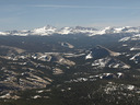
Clouds Rest、Half Dome、Mt. Hoffmann。Tenaya LakeとMay Lakeが写っていますので、探してみてください。
Tenaya Lake(標高8,150ft.)の雪氷は、一週間でかなり融けてしまいました。
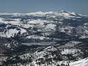
May Lake(標高9,329ft).。
2009年05月16日
Half Dome トレイル オープン
Half Dome Cables in Place in Yosemite National Park
The cables allowing trail access for hikers to the summit of Half Dome are up and open for the season today, May 15,
2009.
The Half Dome hike is a round-trip hike of over 17 miles and is considered extremely strenuous. Hikers gain 4,800 feet of elevation along the hike that passes highlights such as Vernal Fall and Nevada Fall, before reaching the cables on Half Dome’s steep granite shoulder. A series of metal cables are placed along the steep shoulder of the dome to assist hikers to the summit. Visitors are advised to take appropriate precautions when planning a hike of this length and difficulty, and to be prepared for changing weather and trail conditions. Thunder and lightening are common occurrences in the High Sierra during the summer and fall; hikers should not to attempt to summit Half Dome around or during thunderstorms and are advised to use
extreme caution when the rocks are wet.
-NPS- (K. Cobb - 5/15/09)
*************************************************
2009年05月15日
CA108 (Sonora Pass) Open
まだ交通規制がありますが(金曜午後からは解除)、CA108(Sonora Pass越え)は開通しています。
SR 108
[IN THE CENTRAL CALIFORNIA AREA]
IS CLOSED 16.2 MI EAST OF STRAWBERRY (TUOLUMNE CO) FROM 1100 HRS TO
1300 HRS WEDNESDAY THRU FRIDAY THRU 5/15/09 - DUE TO CONSTRUCTION - A DETOUR IS
AVAILABLE
1-WAY CONTROLLED TRAFFIC 16.2 MI EAST OF STRAWBERRY (TUOLUMNE CO) FROM
0800 HRS TO 1100 HRS & FROM 1300 HRS TO 1800 HRS TUESDAY THRU FRIDAY THRU
5/15/09 - DUE TO CONSTRUCTION
2009年05月14日
Bicycles on Tioga Road
Bicycles on Tioga Road - On Friday May 15, Tioga road will be open to all vehicles to Yosemite Creek and to bicycles to May Lake junction.
Administrative travel is allowed beyond Yosemite Creek gate. Please keep in mind that signage along the road is accurate because it is updated each day as conditions change. A sign at May Lake junction indicates that bicycles are not allowed past that point. Also, any administrative traffic should be on the lookout for bikes so that we can provide visitors that experience without interfering with opening operations. (S. Sprouse - 5/13/09)
2009年05月12日
YNPの秘密兵器?
先日のおまけです。Olmsted Pt.においてあったもの2点ほど。
[1] US Gov.はMade in USAのみを使うわけではないようです。路上においてあったYAMAHA社製のスノーモービル(RS Venture)2台。それともこれはUSで製造されたものでしょうか。
[2] 監視カメラ。データを衛星に送っているのか、Sentinel Domeの無線塔に送っているのか、携帯を内蔵しているのか、はたまたLANが地中を通っているのか不明。カメラは白い箱の黄色の丸い部分。ソーラパネルや風向計つき。
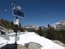
で、じっと見つめていたのはOlmsted Pt.の斜面。雪崩の観測用に設置したと思われます。
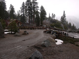
2009年05月10日
ヨセミテ 5月9日
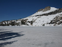
Tenaya Lake。出水口付近の水面が現れ始めました。
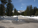
Tioga Road:SunriseのTHからOlmsted Pt.方面。
Olmsted Point。除雪跡にチャコールをふりかけ融雪を促進。
道路保全中のNPS staffと話をすることができました。その中から数点ほど。
[1]今年は、Olmsted Pointを通過するのにたった2時間しかかからなかった。その後数回発破をしかけ、危険な雪の部分を取り除いた。
[2] Tioga Roadの開通日は19?23日あたりのよう。
[3]チャコールで岩が黒くなるのではと聞いたら、後で水洗いするとのこと。
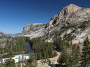
Olmsted Point、Clouds Rest、Half Dome。
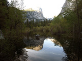
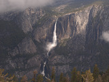
ミラーレイク(夕方)。Tenaya Creekの水量はかなりありますが、レイク自体はあまりぱっとしていません。
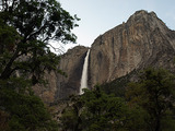
ヨセミテフォール(夕方)
2009年05月09日
Mariposa Groveトラムツアー運行開始
Mariposa Groveトラムツアーが今シーズンの運行を開始しています。
このツアーは予約はいりません。現地でチケットを買い列に並ぶだけです。
--
The Mariposa Grove Big Trees tram tours are available daily starting May 8, 2009. There are no advance
reservations, you may book a tour at the Mariposa Grove. Please call direct at 375-1621 for rates and departure times. (V.McMichael - 5/8/09)
2009年05月08日
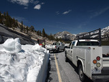
Tioga Road除雪状況 (5/6)
Tuolumne Meadows Visitor Center前に到着。
勝手な予想ですが、開通は17-23日の週の後半になりそうです。
Tioga Road progress for May 6, 2009
Starting Location: 35.2 miles from Crane Flat Gate
Ending Location38.6 miles from Crane Flat Gate (TM Visitor Center)
Distance plowed today 3.4 miles
Average Snow depth: 4.5 ft..(T. Ludington - 5/7/09)
Tioga Road progress for May 5, 2009
Starting Location: 32.7 miles from Crane Flat Gate
Ending Location: 35.2 miles from Crane Flat Gate
Distance plowed today 2.5 miles
Average Snow depth: 4.5 ft .(T. Ludington - 5/6/09)
Tioga Road Plowing Update for May 4:
Start: 31.9 miles from Crane Flat
End: 32.7 miles from Crane Flat (Spring Hill)
Distance plowed: 0.8 miles
Average snow depth: 3.5 feet
Tioga Road Plowing Update for May 1:
Start: 28 miles from Crane Flat
End: 32 miles from Crane Flat (Spring Hill)
Distance plowed: 3.8 miles
Average snow depth: 3.5 feet
Tioga Road Plowing Update for April 30:
Start: 26.9 miles from Crane Flat (May Lake turnoff)
End: 28.2 miles from Crane Flat
Distance plowed: 1.3 miles
Average snow depth: 3 feet
Tioga Road progress for April 28, 2009
Starting Location: 25.1 miles from Crane Flat Gate
Ending Location: 26 miles from Crane Flat Gate (May Lake Turnoff).
Distance plowed today .9miles
Average Snow depth: 4.5ft. (T. Ludington - 4/29/09)
Update on Tioga Road for April 28, 2009
Plows have reached Yosemite Creek and average depth of snow is 3 feet.
Plowing and widening of roadway will continue. (T. Brochini - 4/28/09)
Tioga Road progress for April 22, 2009
Starting Location: 11.7 miles from Crane Flat Gate (just beyond 8,000' Marker)
Ending Location: 14 miles from Crane Flat Gate (White Wolf Gate).
Distance plowed today: 2.3 miles
Average Snow depth: 5.5 ft. (T. Ludington - 4/23/09)
Tioga Road Plowing Update for April 21:
Start: 7 miles from Crane Flat
End: 11.7 miles from Crane Flat (8,000 foot marker)
Miles plowed today: 4.7 miles
Average snow depth: 4.5 feet
Tioga Road Plowing Update for April 20:
Start: Crane Flat
End: 7 miles past Crane Flat (just beyond South Fork bridge)
Miles plowed today: 7 miles
Average snow depth: 4 feet
South Forkの橋は、Tioga RoadのT5マーカーがあるところ。
2009年05月07日
Valley内交通規制解除
これまで閉じていたメルセド川北側の道路が開通、南側の交通規制も解除の予定。
Valley Roads update
Here's some really good news... ! ! (subject to the usual disclaimers and unforeseeable acts of nature....)
Northside Drive will open for two lane, one way traffic westbound from Camp 4 to the Pohono Bridge by 5PM this Thursday, May 7, 2009. Southside Drive will open for two lane, one way traffic eastbound from El Cap Crossover to the Curry Village intersection by 5PM this Friday, May 8, 2009.
"River Straight" (between the Curry and Camp 6 intersections) will revert back to two lane, one way traffic
westbound with the south lane redesignated for "Special Use Only" (emergency vehicles, NPS/DNC utility vehicles and shuttle buses only)
Additional road construction news -
El Cap crossover will close between Southside and Northside Drives on Monday, May 11,2009. The crossover will remain closed to all but emergency vehicles through May 22, 2009. The closure is for grinding, repaving and restriping. The contractors anticipate all painting and signage to be in place by Friday May 22, 2009
2009年05月06日
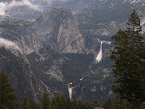
Clark Pt. ? Nevada Fall間のJMT開通
Trail Update: The Ice Cut section of the John Muir Trail is open for the season. (R. Lewis - 5/5/09)