2006年07月 アーカイブ
- 2006年07月31日 中小規模の崖崩れ発生(7/27)
- 2006年07月31日 Hetch Hetchy問題再燃?
- 2006年07月28日 Yosemite周辺で聞けるラジオ局
- 2006年07月28日 140号:仮設の橋がほぼ完成、開通7月31日
- 2006年07月27日 山火事のシーズン始まる?
- 2006年07月26日 Tioga Road
- 2006年07月25日 Bear Activities
- 2006年07月24日 Yosemite Creek
- 2006年07月20日 140号岩崩れの報告書
- 2006年07月04日 Tuolumneエリアの施設オープン
- 2006年07月03日 El Capitan Shuttle Bus
- 2006年07月01日 White Wolf Campground Open
2006年07月31日
中小規模の崖崩れ発生(7/27)
NPSによるとヨセミテヴァレーで27日午後に2件の崖崩れがあったようです。1ヶ所はセンチネルロックの東(4マイルトレイルを横断)、もう1ヶ所はハーフドームの北西壁。いずれもハイカーやクライマーに被害はない模様。
Two small to medium-sized rockfalls occurred in Yosemite Valley on Thursday, July 27. The first occurred at approximately 4:30 pm near the Four Mile Trail east of Sentinel rock, and consisted of a few small blocks that fell from a cliff band and rolled down a gully to the floor of Yosemite Valley. Although the rocks crossed the Four Mile Trail, no one was injured and the trail remains open. The second occurred at approximately 6:30 pm on the northwest face of Half Dome. A flake fell from low on the Northwest Face into a gully below the face, quickly breaking up into dust and small debris. Dust was visible over Half Dome for several minutes after the rockfall. At approximately 7:30 a helicopter reconaissance located the rockfall release point and determined that no climbers or hikers were injured by the rockfall. (G. Stock - 7/31/06)
Hetch Hetchy問題再燃?
先週カリフォルニア州の方から、Hetch Hetchyダムの撤去に関するレポート(11MB)が出てから、いくつかの新聞で関連記事が出始めています(LA Times/San Jose Mercury, SF Chronicle、Sacramento Bee)。各紙の問題に関するスタンスがわかり面白いですね。
関連記事一覧はこちら。
2006年07月28日
Yosemite周辺で聞けるラジオ局
Yosemiteの行き帰り、どうしてもニュースが気になるときがあります。
KCBS(AM740KHz)では、ベイエリアの交通状況も含め24時間ニュースを放送しています。
かなりノイズが入りますがTioga Roadでも受信できます。もちろんセントラルバレー(120号)ではOKです。
参考: www.kcbs.com
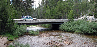
140号:仮設の橋がほぼ完成、開通7月31日
時間制限で一般車両(長さ28ft以下)も通れそうです(東に行く場合は朝6時に並んでいること)。
ソースはこちら: http://www.inciweb.org/incident/236/
基本的には、ヨセミテ渓谷内で働く人のための橋考えたほうがよさそうです。
(Mariposa County) The California Department of Transportation (Caltrans) will be opening Highway 140 to limited one-way controlled traffic on Monday, July 31, 2006. Vehicles using the temporary Highway 140 bypass are limited to lengths of twenty eight feet or less.
Following a pilot car and in a “caravan-type” fashion, motorists will cross the Merced River for a six mile detour around the slide on a partially paved road. It is expected that the first caravan for westbound traffic will leave east of El Portal at the Foresta Bridge at 5:30 a.m. Travelers must be in line by 5:30 a.m. to be allowed to join this caravan. This will be followed by a caravan for eastbound traffic which will leave from approximately five miles east of Briceburg at 6 a.m. Travelers must be in line by 6 a.m. in order to be allowed to join this caravan.
In the evening, the caravan for westbound traffic will leave east of El Portal at the Foresta Bridge beginning at 6 p.m. Traffic flow will alternate in direction until the final evening caravan leaves westbound at 7:30 p.m. In order to join the final westbound evening caravan, travelers must be in line east of El Portal at the Foresta Bridge by 7:30 p.m.
As this is a controlled one-way limited opening, vehicles must be in line before each opening to be allowed to join the caravan. Motorists should be aware the speed limit on the detour will be 15 miles per hour.
The California Highway Patrol will be on site to enforce construction work zone rules and regulations. Due to roadway limitations, pedestrians and bicyclists will not be allowed on the temporary Highway 140 bypass. Vehicles using the temporary Highway 140 bypass are restricted to twenty eight feet in length.
2006年07月27日
山火事のシーズン始まる?
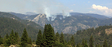
写真:ヨセミテ北西部、Lake Eleanor付近の山火事(7月29日)
公園内にはいくつかの雷による火事が(特にHetch-Hetchy方面に)発生しているようです。朝のヨセミテ渓谷Live Camが煙っているように見えますが、流れ込んできた煙のせいなのでしょうか、それともキャンプファイアの煙?
Yosemite Fire Information Update #9 - July 25, 2006
Three new lightning ignited fires were discovered burning in Yosemite National Park. Due to lack of resources and the hotter and dryer weather, fire managers have decided to suppress two of these fires. The Miguel Fire and the Half Moon Fire are expected to be contained by today (7/25/06). The Bart Fire will be managed for resource benefit. Thunderstorms are forecasted thru the end of this week and fire mangers are anticipating additional lightning strikes with possible new fire starts.
For public safety, the Laurel Lakes basin is closed. This closure includes the Miguel Meadow to Laurel Lake trail.
All wildland fire use fires are routinely monitored to ensure that the programs goals are met. Visitors may see smoke from these fires.
(*) Indicates the date the fire was detected
・ Bart Fire(*7/24) is located near Bartlett Creek, 1/2 mile north of Flora Lake. It is currently 1/4 of an acre burning in brush and dead and down fuels. This fire is surrounded by natural barriers with low potential for growth.
・ Half Moon Fire (*7/24) is located 1/2 mile from Half Moon Meadow in the Yosemite Creek drainage. It is currently 1/10 of an acre burning in red fir needle litter and down logs. Suppression tactics have been implemented and this fire is expected to be contained by today (7/25/06).
Frog Complex (The following fires are being managed as the Frog Complex)
・ Miguel Fire (*7/23) is located 1/8 of a mile east of the Miguel Meadow to Laurel Lake trail. It is currently 1/4 of an acre smoldering and creeping in mixed conifers and black oaks. Suppression tactics have been implemented and this fire is expected to be contained by today (7/25/06).
・ Laurel Fire (*7/21) is located 1 mile west, south west of Laurel Lake. It is currently 10 acres and burning in mixed conifers with moderate to high potential for growth. This fire may be visible from Lake Eleanor.
・ Frog Fire (*7/21) is located 2 miles north from Laurel Lake in the Frog Creek drainage. It is currently 4 acres. This fire is burning in red and white fir with moderate potential for growth.
・ Middle T Fire (*7/21) is located 3 miles east of Aspen valley on the north side of the Middle Fork of the Tuolumne River and near the Long Gulch Trail (between White wolf and Aspen Valley). It is currently 3 acres with moderate to high potential for growth.
・ Kibbie Fire (*7/22) is located 1/2 mile west of Kibbie Lake. It is currently 15 feet by 15 feet (15’x15’) burning in brush surrounded by natural barriers. This fire has low potential for growth.
・ King Fire (*7/18) is located 2 miles east of Mount Starr King. It is currently 50 feet by 50 feet (50’x50’) burning in sparse bushes and down logs. This fire has low potential for growth.
・ Falls Fire (*6/28) is located two miles north of Hetch Hetchy, and east of Falls Creek. It is currently 32 acres and burning in western white pine needle cast with moderate potential for growth
These fires are currently inactive:
・ Double Rock Fire (*7/17) is located approximately 11/2 miles north east of White Wolf.
・ Lukens Fire (*7/17) is located approximately1 mile north of Lukens Lake.
・ Hidden Fire (*7/10) is located 1/4 mile south west of Hidden lake and 1mile south of the Tioga Road.
・ Horizon Fire (*6/26) is located on Horizon Ridge between Ostrander Lake and Glacier Point Road. .
2006年07月26日
Tioga Road
タイオガロード(Tioga Road)は、ハイシエラ(High Sierra)、もしくはハイカントリー(High Country)と呼ばれるヨセミテ国立公園の高山地帯を、東西に横断する全長46マイルの山岳道路です。巨大な岩壁群と、滝の景観が見所のヨセミテ渓谷とは、全く趣の異なる三千メートルを越える山々、氷河によって作り上げられたドーム群、それらを取り囲む森林、湖、メドウなどの複合した景観を楽しむことが出来ます。以下シリーズで、Tioga Road沿いの見所・要所をまとめていきたいと思います。
[注意]:Tioga Roadは積雪のため、初夏から秋にかけての半年ほどしか開通していません。また道路開通・閉鎖の時期は積雪によって大きくずれますので、旅行計画には注意が必要です。
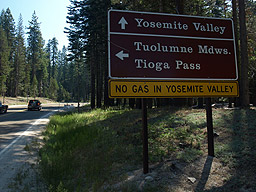
[写真:Tioga Roadへの交差点]
まず初回はTioga Roadの西側の基点となるBig Oak Flatとの交差点です。此処はBig Oak Flatの公園料金所からCA120を8マイルほど進んだ地点、Merced Groveの少し先にあります。初めてヨセミテを訪れるときは、ヨセミテ渓谷に向かうことに気をとられ、気づかず直進してしまう所ですが、一度Tioga Road沿いでの楽しみ方を知ると、此処で左折する回数のほうが増えてしまいます。
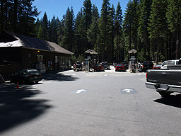
[写真:Gas Stand]
交差点のすぐ横にはガソリンスタンド(年中無休、24時間セルフサービス)があります。燃料に不安がある方は、此処で給油をしておきましょう。
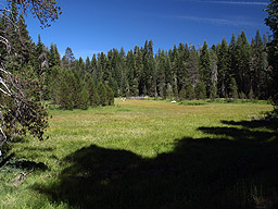
[写真:Crane Flatのメドウ]
交差点を曲がり、木立の中を半マイル弱も進んでいくと、やがてメドウが現れます。このあたりはCrane Flatと呼ばれています。John Muirは『My First Summer in the Sierra』(1911年)の中で、”It often visited by blue cranes to rest and feed on their long journeys, hence the name.”と、そこを訪れる鶴が名前の謂れであると書いています。余談ですが、Josiah Whitneyは、『The Yosemite Book』(1868年)の中で、El Capitan(エルキャピタン)がインディアンによって”Totokonula”と呼ばれており、それは冬にこの岩壁を越えて渓谷に訪れる鶴の鳴き声を真似た呼び方だと説明しています。 現在でも鶴が見られるのでしょうか。
T1
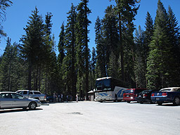
[写真:Tuolumne Grove駐車場]
メドウのすぐ先には、セコイアの森Tuolumne Groveの駐車場があります。ヨセミテ国立公園にはセコイアの森が3つあり、最も有名なのは公園南端WawonaのMariposa Groveですが、他の二つはここと前述のMerced Groveです。両者ともMariposa Groveに比べかなりスケールが落ちますが、ヨセミテ渓谷やTioga Road周辺を訪れるついでに、セコイアの木を見てみたいという方には便利なスポット です。特にTuolumne Groveは駐車場から歩いて1マイル、高度差400ft.とアクセスの便がよく、一年を通し、週末にはかなりの人と車で賑わいます。
ところで、1833年に現在のTioga Roadにかなり近いルートでシエラネバダを横断し、ヨセミテ渓谷を初めて遠望した白人はJoseph Walkerの探検隊のメンバーですが、その一人Zenas Leonardは後に公開した日誌(1839年)の中で、”In the last two days travelling we have found some trees of the Red-wood species, incredibly large - some of which would measure from 16 to 18 fathoms round the trunk at the height of a man's head from the ground.”と、巨大な木の発見を書きとめています。これがTuolumneなのかMerced Groveなのかは知るすべはありませんが、最初のセコイア発見の記録として知られています。
T2
[写真:旧Big Oak Flat RoadとTioga Road]
Tioga Roadは、Tuolumne Grove駐車場(標高約6,170ft.)のすぐ先から、樹林帯の中の小さな尾根筋を幾度も回りこむようにして高度を上げていき、やがて平らな尾根の上(標高約7,000ft.)に出ます。ここは旧Big Oak Flat Roadと交差するところで、道路の左側にロードサイドマーカーT2が立っています。左側の旧道はCrane Flatへと下り、さらにTuolumne Groveを通り過ぎBig Oak Flatの公園入り口へと続いています。右側は、Tamarack Flatのキャンプグランドへのアクセスロードとして現在も車両通行が可能になっています。しかしその先は、徒歩でのみ通行可の廃道となり、Tamarack Creekを越え、El Capitanの西側の斜面を辿り渓谷へと下っていきます。この道路は1874年に開通した古いものですが、1940年には、現在の主要道路であるBig Oak Flat Roadが開通し、El Capitan近くで大きな岩崩れがあったこともあり、1943年に閉鎖されてしまいました。
T3
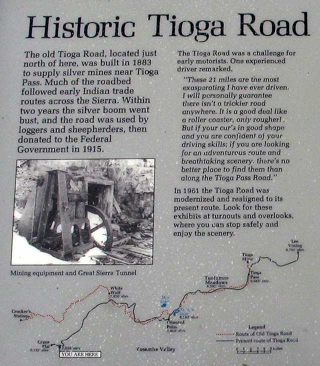
[写真:Gin Flat]
T2マーカーの100メートルほど先はGin Flatと呼ばれ、T3マーカーが立っています。舗装された駐車場には簡単な案内板があり、Tioga Road、旧Tioga Roadの歴史が述べられています(”YOU ARE HERE”と書かれた現在位置の表記場所が誤っていますので注意)。旧Tioga Roadはヨセミテ国立公園(1890年制定)よりも歴史が古く、1883年にTioga Pass付近の銀鉱山への補給路として建設されました。しかし鉱山事業は数年で破綻してしまい、1915年、Stephen T. Mather(1916年よりNPS初代長官)は私費と集めた募金で道路を買い取り、政府へ寄付しました。Linda W. Greeneの『Historic Resource Study:Yosemite』(1987年)によると、Ginの名の由来は、昔此処を通過したワゴンからジンの酒樽が転がり落ち、それを見つけた労働者らが飲んで酔っ払い、いつまでも帰らず捜索騒ぎになったことにあるとのことからです。此処から先Tioga Roadは、TuolumneとMerced水系を分ける尾根に沿うようにして東へと進んでいきます。
Crane Flat/Tuolumne Grove駐車場(T1)---<3マイル>---Old Big Oak Flat Rd.(T2)---<0.1マイル>---Gin Flat(T3)
T4
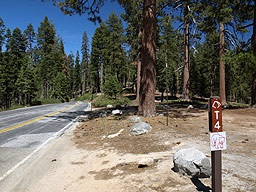
[写真4.1:T4マーカー]
Gin Flat(T3)から尾根沿いに1マイル進むと、T4マーカーのある未舗装の駐車場が右手に現れます。Yosemite Associationの『Yosemite Road Guide』には、1833年にWalker隊が、この尾根を通過したであろうと書かれています。今でこそTioga Roadを使い、車で1時間もあれば横断できるヨセミテですが、当時は獣道に近いようなインディアントレイルしかありませんでした。その上、Walker隊が山を越えたのは10月後半で、すでに初冬の嵐が通り過ぎ、かなりの積雪が残っていました。隊の記録係Zenas Leonardの日誌には、Mono Lakeを出てから食料も尽き、倒れた馬の肉を食べながらかなりの苦労をし、3週間をかけてヨセミテ越えをしたと書かれています。[注意:隊の横断についての案内板があるとのことですが、現在見当たりません。]
T5
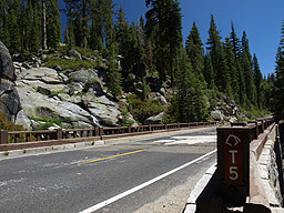
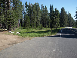
[写真:South Fork Tuolumne River(西向きに撮影)]
ここから道路は、わずかですが下り気味に尾根沿いを進んでいきます。そして1マイル強ほどで、突然右側に開けた谷が現れます。これはTamarack Creekの源流部で、大きな山火事の被害の跡が残っています。木は殆ど焼けてしまい、枯れた立木(Snag)が数多く見られます。そして日当たりがよくなってしまった斜面には、潅木がいっぱいに生えています。此処でHetch Hetchy方面とTamarack Flat CGを結ぶほとんど使われていないトレイルが横断し、谷の下流、Tamarack Flat CG方面には、『Devils Dance Floor』という面白い名を抱いたドーム状の山を望むことが出来ます。此処からTioga RoadはTuolumne水系の斜面に回りこみ、1マイル強ほどで長い直線部が現れます。その最低部にはSouth Fork Tuolumne Riverを越す橋が架かっています[写真4.2、進行方向の逆向きに撮影]。この沢は、Tioga Roadが開通してからしばらくの間、かなりの勢いで水が流れ、車を停めて見入る人々がよく見受けられます。
Gin Flat(T3)---<1マイル>---Walker Party(T4)---<2.6マイル>---South Fork Tuolumne River(T5)
T6
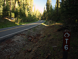
[写真: T6 Smoky Jack]
South Fork Tuolumne River(T5)から1.8マイル進んだところに、Smoky Jackと呼ばれるT6マーカーがあります。ここは両側に林が迫り日当たりが悪く、ちょうど道路のカーブにあたり、簡単に見逃してしまいます。もし左側になだらかで広い岩の斜面が出てきたならば、すでに時遅しです。 Yosemite Road Guideによれば、ここには以前簡易キャンプ施設があったとのことで、確かに右側、木々の陰に平地が見えています(現在は岩でふさがれ侵入不可)。
Smoky JackはJohn Conellのニックネームで、1868年末から1869年5月末にかけて、John MuirがセントラルバレーのLa Grange・Snelling近くで羊飼いをしていたときの雇用主です。Muirは1872年に簡単な旅行記”Rambles of a Botanist Amoung the Plants and Climates of California.”を書き、その中でConnelが豆を主食とし、朝食のあとは汁のこぼれる豆をポケットにつめて昼食としていたこと、このため着ているオーバーオールやブーツは豆の汁を吸ってかなり分厚い物となっていたと、その奇異な習慣について書いています。どのような所以でこの人物の名がここに付けられたのかは、不明です。
T7
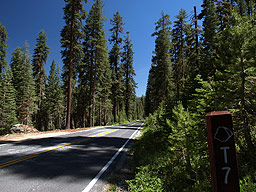
[写真: T7 Red Fir Forest、進行方向逆向きに撮影]
T6を過ぎ、1.3マイルほど進んでいくと、道路の両側には立派なRed Fir(Abies magnifica:樅)が目立ちはじめます。Muirは『The Mountains of California』の中で、Magnificent Sliver Firとも書き、その見事なまでの対称さは、シエラネバダの巨木のなかで群を抜いており、その紫がかった赤い樹皮から簡単に見分けられると書いています。『National Audubon Society Field Guide to North American Trees』によると、Red Firは高さにして18-37メートル、直径30cmから1.2メートル、主に標高6000?9000フィート地帯に見られ、ヨセミテではかなりポピュラーな木だと書かれています。そしてMuirの文を真似るかのように、昔の山岳旅行者たちは、香りのすばらしいこの木の枝を切って重ね、ベッド代わりにしたと書いています。
South Fork Tuolumne(T5)---<1.8マイル>---Smoky Jack(T6)---<1.3マイル>---Red Fir Forest(T7)
注意:Smoky JackとRed Firの間の距離1.3マイルは、ガイドブックの数字をそのまま転用したものですが、間違い(近すぎ)があるように思えます。
2006年07月25日
Bear Activities
上から2番目と下から2番目は要注意ですね。
前者に関しては、たまにずさんにロックしたBoxを見かけます。熊も賢いので、開け方をかなり学んでいるんでしょうか。後者は油断も隙もないというところでしょうか。食料の入ったパックを横においておき、滝などに見とれていると奪われてしまうといった感じですか…
Weekly Bear Activity
*Bears continue to be active in all Valley campgrounds. There is a bear that checks the cars at Camp 4 on a nightly basis. She also seeks food in the campground.
*A large bear has been obtaining food from lockers that are improperly locked in the Pines campgrounds.
*A small bear was observed eating garbage in the Curry Village area.
*There were 5 car break-ins in the East Valley developed areas.
*Bears have been observed foraging naturally in the meadows near Crane Flat.
*A bear has been observed in the White Wolf campground, attempting to obtain food.
*A bear has been observed on the Mist Trail. Keep your food within arms reach at all times!
*In the backcountry, most observations have been from Cloud’s rest to LYV.
2006年07月24日
Yosemite Creek
金曜からカリフォルニアを熱波が襲っています。土曜のヨセミテは、かなり湿度が高めでした。写真は、Mt. Hoffmann(右)の北側(Yosemite Creekの水源の一つ)
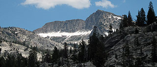
と、Yosemite Creek(Tioga Roadと交差する地点、Ten Lakesトレイルヘッド)です。水量は落ちているものの、まだ水遊びは充分できそうです。
2006年07月20日
140号岩崩れの報告書
正式名称 Ferguson Rock Slide の地質学的見地の報告書が出ています。
落石によりMerced川がせき止めされるという、最悪の状態が起きる可能性は低いようです。
写真と地図は必見。USGS版はこちら。
ところで、仮設の橋の建設が下流で始まっています。
2006年07月04日
Tuolumneエリアの施設オープン
Tuolumne Meadowsエリアをはじめ、タイオガロード沿線の諸施設がオープンしています。これでほぼすべての施設・エリアが夏期シーズン入りしたことになります。
Yosemite National Park Announces Opening of Tuolumne Area Facilities
Numerous lodging, camping, and recreational opportunities are now open for visitors to Yosemite National Park's glorious high country!
Highways 120 and 41 provide access to all areas within Yosemite National Park.
Yosemite National Park Superintendent Mike Tollefson announced the opening of many Tuolumne area facilities today, June 30, 2006, in time for the July 4th weekend.
The Tioga Road (Highway 120 east), with its views of spectacular granite domes, pristine alpine meadows, and just-peaking wildflowers, offers visitors an incredible day trip or an unforgettable overnight stay. For visitors looking for a true Wilderness experience by foot, the Tuolumne area offers miles of hiking trails which provide an open door to Yosemite's High Sierra.
Among the facilities now open is the Tuolumne Meadows Wilderness Center. The Tuolumne Meadows Visitor Center will open tomorrow for the summer season. It will be open daily from 9am to 6pm. Many area campgrounds including White Wolf, Tamarack Flat, and Crane Flat are now open for the season. Both Tamarack Flat and Crane Flat have first-come, first-served campsites available. Additionally, the Bridalveil Creek campground (located off of the Glacier Point Road) is open and available for first come, first-served campers.
The Tuolumne Meadows Store, the gas station, and Tuolumne Meadows Lodge and the White Wolf Lodge are opening today. Both accommodations also offer meals. Information about lodge accommodations can be found at www.yosemitepark.com.
Many unique and exceptional activities are held yearly in the Tuolumne Meadows area. These include the Parsons Memorial Lodge Summer Series, a series of lectures, art and music shows, interpretive programs, and seminars offered at the historic Parsons Memorial Lodge and the 10th Annual Tuolumne Meadows Poetry Festival. More information about these and other activities offered at the Parsons Memorial Lodge can be found on the web at www.nps.gov/parsons.
Along with the Tioga Pass entrance (Highway 120 east), visitors can access Yosemite National Park from Highway 120 (west) and Highway 41 (south). Highway 140 is closed due to rockslide, but all Mariposa, Midpines, and El Portal area businesses and accommodations are open for business.
For more information, please call the Public Information Office at Yosemite National Park at 209/372-0200, or visit us on the web at www.nps.gov/yose. (-NPS-)
2006年07月03日
El Capitan Shuttle Bus
昨年夏、実験的に運行されていましたが、ビジターセンターからエルキャピタン方面へのシャトルバスが9/4まで運行されます。毎時00分と30分発の2本で18:00まで。
The new El Capitan Shuttle Bus will be operating daily from 9 am to 6 pm through Labor Day (Sept. 4). It leaves the Visitor Center (Valley Shuttle stop #5) every hour and half hour with the last run leaving at 6 pm. Stops include the Visitor Center, El Capitan Picnic Area, El Capitan Meadow and the Four Mile Trailhead. Shuttles stop at designated stops only. (W. Malone - 6/29/06)