2006年06月 アーカイブ
- 2006年06月28日 YARTSバス時刻表変更
- 2006年06月25日 Priest’s Grade
- 2006年06月21日 Tamarack Flat Campground Open
- 2006年06月18日 Tuolumneの五名瀑
- 2006年06月18日 Tioga Road開通 : June 17 2006
- 2006年06月16日 120号線沿線のサービス
- 2006年06月15日 Tioga Road 17日開通予定!
- 2006年06月12日 ヨセミテ遠望
- 2006年06月11日 The Tuolumne Shuttle
- 2006年06月10日 140号崖崩れ:Web
- 2006年06月10日 6月トレイル情報
- 2006年06月08日 学校のヨセミテ宿泊学習
- 2006年06月06日 140号の崖崩れ現場写真
- 2006年06月06日 SD Cam復活
- 2006年06月01日 2006 Tioga Road除雪ログ
2006年06月28日
2006年06月25日
Priest’s Grade
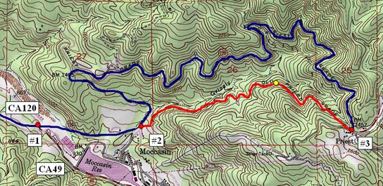
Don Pedro貯水湖を通り過ぎ、CA49との分岐(#1、Moccasinの発電所の前)を過ぎると、いよいよCA120号最初の峠道が始まります。最初の左カーブの手前ですぐ右折(#2)すると、旧道の「Old Priest’s Grade」を上ることになります。2マイルで高度差500メートルを稼ぐ、かなりの急坂です。上りきったところで、再びCA120号に合流します(#3)。120号本線は5マイル弱ほどの長さで、2倍以下の傾斜です。
ここを上りきれば、Grovelandまであと5マイル弱です。
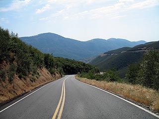
地図の黄色地点から西を撮影。本線が反対側の斜面に見えています。ここを下るときは、Automaic車でもエンジンブレーキをお忘れなく。 ガードレールはありません。
「Old Priest's Grade」の補足記事です。
2006年06月21日
Tamarack Flat Campground Open
The first-come first-serve Tamarack Flat Campground has opened for the season. (6/20/06)
NPS
2006年06月18日
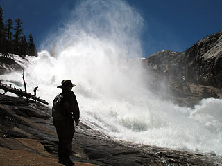
Tuolumneの五名瀑
Waterwheel滝の写真です。 Tuolumne Riverは水があふれかかっていました。
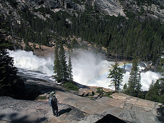
参考: 去年の7月の写真は こちらです。
ビデオ撮影ポイント地図
1. Tuolumne Riverは、Tuolumne Meadowsの西端付近から傾斜がつき始めます。
2. やがて最初の滝、Tuolumne滝が出現。
3. そのすぐ下にはWhite Cascade滝があり、プールのすぐ横にGlen Aulin High Sierra Campがあります。
4. Glen Aulin HSCの横の高台からは、Tuolumne、White Cascadeの滝、そしてGlen Aulinの谷が見渡せます。
5. 平らな谷底を進むとやがてCalifornia滝が出現。
6. トレイルはTuolumne Riverに沿って作られ、豪快な音を楽しめます。
7. 次にLe Conte滝。
8. そしてWaterwheel滝が出現。
9. 時間があれば、ぜひ滝の中段付近まで下りましょう。
注意:カメラの欠陥?のため画質に問題(右側が紫色になる)があります。動画ファイルサイズは4-7Mの間です。

2006年06月16日
120号線沿線のサービス
トイレはテナヤレイク、ランバートドームほかいくつかのトレイルヘッドで使用可能。
トゥオロミーメドウズのストア、ガソリンスタンド、トゥオロミーメドウズのロッジは7月上旬に開店予定。
キャンプグラウンドのオープンはまだ未定のようです。
タイオガロード(120号線)が開くと、ウキウキしてきますよね。
待ちこがれたハイカントリーの夏シーズンを満喫してください。
Services along the Tioga Road and in Tuolumne Meadows will be limited. Vault toilets will be available at Tenaya Lake, Lembert Dome, and some trailheads. The Tuolumne Meadows Store, Gas Station, and the Tuolumne Lodge are expected to open in early July. All campgrounds along the Tioga Road corridor (including White Wolf, Tamarack Flat, Yosemite Creek, Porcupine Flat and Tuolumne Meadows) will remain closed until further notice.
2006年06月15日
Tioga Road 17日開通予定!
Caltransによると17日朝8時開通予定です。
Suyamaさんの発見でした!
SR 120
[CENTRAL CALIFORNIA & SIERRA NEVADA]
IS CLOSED FROM 12.3 MI EAST OF CRANE FLAT TO 11 MI WEST OF THE
JCT OF US 395 /TIOGA PASS/ (TUOLUMNE, MONO CO's) - WINTER CLOSURE - MOTORISTS
ARE ADVISED TO USE AN ALTERNATE ROUTE - THE YOSEMITE NAT'L PARK WEST ENTRANCE
IS OPEN - THE ESTIMATED TIME OF REOPENING IS AT 0800 HRS ON SATURDAY 6/17/06.
追加: NPSも正式発表しました。
The Tioga Road is scheduled to open on Saturday, June 17 at 8 am.
2006年06月12日
ヨセミテ遠望
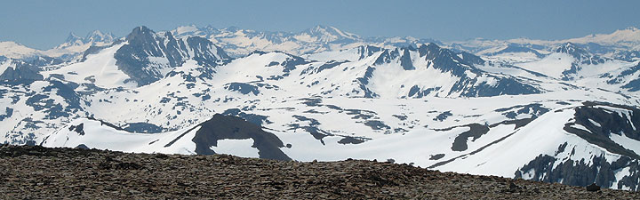
6月11日:108号Sonora Pass付近の山から、ヨセミテNP西半分を写した写真です。
視界50マイル以上。左のほうに見えている山々は、Banner Peak、Mt. Ritter(Ansel Adams Wilderness)、Tower Peak(手前の大きい山:Yosemite NPの北端)、 Mt. Lyell(Yosemite NPの南東端にある公園内最高峰)です。Tuolumne Meadowsは撮影地点とLyellを結ぶ直線上にあります。
9,000ft.以上の北側斜面にはまだ雪がたくさんあります。個人的予想ですが今週末はTioga Rd.が開通しそうです。
2006年06月11日
The Tuolumne Shuttle
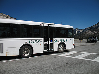
2006の写真ですが、バスはこんな感じです(Olmstedにて)。
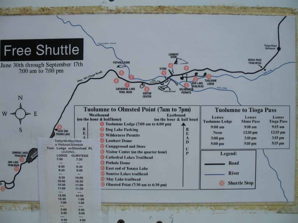
こちらはバスの運行・ルート図。ちょうどバスの裏側にありました(同じく2006年のものです)。
2007-06-11
2006年06月10日
140号崖崩れ:Web
Ferguson Rockslide と命名されたようです。
Sierra National Forestが合同の対策本部を作り、Webに状況が報告されています。現地では24時間の監視が行われています。崩壊しかかっていた公園への送電線の移動は完了したようです。かなり詳細な地図も掲載されています。
2006年06月08日
学校のヨセミテ宿泊学習
6月は学年末ということもあり、学校団体(小学校〜高校)のヨセミテ宿泊学習が多いシーズンです。
こうした学校受け入れプログラムはNPSおよび民間非営利の教育組織「Yosemite Institute」が行っています。
NPSの内部報で来週(6/12-16)の受け入れ校8校が発表されていました。
This week (June12-June 16), YNP and Yosemite Institute will be hosting these fine schools:
El Rodeo School, Beverly Hills.
John Webster Elementary, Malibu.
Springview School, Huntington Beach.
Truckee Elementary, Truckee.
Longfellow Middle School, Berkeley.
Coldstream Alternative School, Kings Beach.
Ocean Charter School, Los Angeles.
Hawthorne High School, Hawthorne.
If you are a graduate of any of the schools or have any other connection to the school or neighborhood, and you have any interest in speaking informally with students from one of these schools, please contact John DiDiego at 379-9514 ext 12, or jdidiego@yni.org to arrange a time and place. (C. Hastings - 6/5/06)
2006年06月06日
140号の崖崩れ現場写真
NPSのニュースより:
The Mariposa website has some stunning photos of the slide taken by the Sheriff's Dept; if you've not accessed it, click on at:
http://www.mariposacounty.org/sheriff/Rock%20Slide%20May%2029%202006.htm
2006年06月01日
2006 Tioga Road除雪ログ
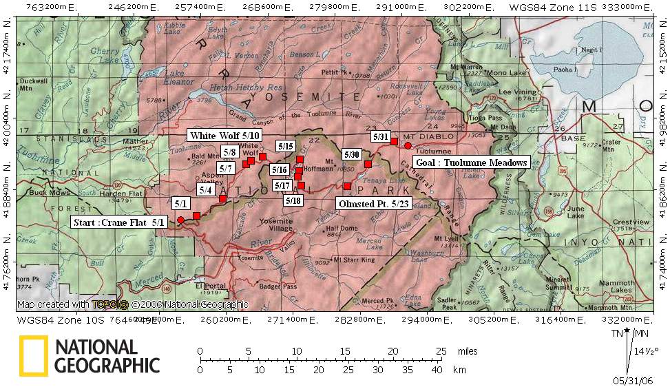
5月1日
* Tioga road progress May 1, 2006 - Today, we were able to begin the opening of Tioga Road. Crews made it to Gin Flat. Snow depth is approximately 5 feet and the snow is very wet and heavy. They found three trees buried in the snow, one of which was over 24" in diameter.
* Glacier Point road progress - No progress report was submitted for Glacier Point road which also started today.
5月2日
* Tioga road progress - May 2, 2006 Plowing operations have reached Big Meadow Overlook. The snow depth is now 7 feet with very dense snow. We have run in to 8 buried trees, some over 24 inches in diameter, that had to be removed so plowing could continue. Our hope is to reach South Fork by Thursday.
* Glacier Point road progress - May 2, 2006 One half mile from Badger Pass. Snow depth is approximately 7 feet. All is going well.
5月4日
* Tioga Road progress:
Ending location: At South Fork Bridge
Snow depth: 8 Feet
Very heavy snow pack, encountered 8 trees with average size of 18-24 inches. We are now at the first avalanche zone. We are expecting to plow through this first zone early in the morning. If the temps go up considerably, crews may be forced to come back West of the zone until the temps drop or the slope stabilizes.
* Glacier Point progress:
Ending location: .8 miles from Badger Pass
Snow depth: 7 feet
Slow progress with rotary due to snow depth and high water content.
5月5日
* Tioga Road:
Started at South Fork Bridge and ended in the middle of Avalanche zone 1. Snow depth is approximately 6 feet. Quite a bit of rock and trees down in the avalanche zone. Will continue through the zone tomorrow.
* Glacier Point Road:
Still under a mile from Badger. No progress today. Loader mounted rotary broke down and needs to be taken to the shop for repairs.
5月8日(朝の報告)
3マイル強も進んでいます。8,000ft.地点は地図からプロットしたものですが、White Wolfへの分岐のすぐ近くのようです。去年のペースを追い抜きそうです。
*Tioga Road:
The crew was able to plow 3.3 miles today. They are now at the 8000 foot marker. Average snow depth is 10 feet. They encountered 5 trees, 3 over 36" diameter and 2 over 24" diameter.
*Glacier Point road:
No report (though, they were able to get going again with the help of one of the rotaries from Tioga Road).
May 8, 2006
*Tioga road progress
The progress today was only 1/2 mile due to equipment breakdowns. Snow depth was 10 feet. We are approximately 1 1/2 miles from White Wolf.
*Glacier Point road progress
Crews have gone up the road a total of 2.3 miles. Snow depth is approximately 5 feet.
May 10, 2006
除雪開始日は、去年より2週間ほど遅れましたが、White Wolfには3日ほど早く到達しました。ここから分水嶺までの2マイルは、北向き斜面で一番雪の深いところです。
GP roadは、約三分の一を除雪。
*Tioga road progress - May 10, 2006
Ended the day at White Wolf. Snow depth is 10 feet
*Glacier Point road progress - May 10, 2006
Crew has now gone 3.2 miles from Badger. Snow depth is 4 feet. No major problems.
May 11
*Tioga Road:
Total progress today was only 1/2 mile. The snow is 10 feet deep and very hard. This is normal progress in the area they are in.
*Glacier Point:
No work on the road today. The crews were diverted to patch potholes on the Wawona Road. Work will resume Monday.
May 15
*Tioga Road:
Saturday, the crews finished the day at approximately 16 miles in from Crane Flat. Snow depth is 11 feet. No major problems. Progress is slow due to the deep and heavy snow.
*Glacier Point:
No work on the road today. The crews were diverted to patch potholes on the Wawona Road. Work will resume Monday.
White Wolfより2マイル進んだようです。分水嶺の付近でしょうか。
May 17朝のポスト
月曜(15日)には3.3マイルも進み、Yosemite Creekに達しました。火曜(16日)には、橋から先の登りの斜面に入っています。GPも残すところ3マイル強くらいです。今週末までにGPに届けば、5月末(連休前)のオープンがあるかもしれません。
*Tioga Road progress May 15
Great progress today. The crews are now at Yosemite Creek Campground. They were able to plow 3.3 miles. The average snow depth is now down to an average of 5 feet. Tuesday, May 16 they start going up Yosemite Creek grade. This will be a slower process and will be entering the Yose Creek avalanche zone.
*Glacier Point Road:
Great progress here too. The Wawona crew was able to plow a total distance of 4 miles. They are now 7.2 miles in from Badger Pass. The average snow depth has dropped to only 3 feet.
May 17夕方のポスト
Tioga Roadは進まなかったようですが、GP Rd.はSentinel Domeが目の前です。あと0.3マイル弱も進めば、道路は一気にGPへと下り始めます。金曜には(とりあえずの)除雪が終了しそうです。
*Tioga Road:
Only plowed 1/2 mile today. Had to stop at the Yosemite Creek avalanche zone. Too late to go on through the zone. Will try to get an ambulance and plow through Wednesday May 17.
*Glacier Point Road:
The road crew is now 8.5 miles from Badger Pass, at Taft Point /Sentinel Dome parking area.
May 18夕方のポスト(17日の記録)
GP Rd. :Washburn pt.に到達。開通予定26日
*Tioga Road
The crew was able to plow through avalanche zone 9 today. They are now 21.1 miles in from Crane Flat
*Glacier Point Road
Today, they made it to Washburn Point. The goal of the crew is to make it to Glacier Point sometime late tomorrow. They will now have to go back and widen the road, do ditching, pot hole repair, and remove one big boulder that is in the road. The road may open to the public with limited services on May 26
May 18の記録
Tioga Rd:Porcupineキャンプ場(道路左側)への下りに入りました。去年は同地点に、5月23日に到着しています。
GP Rd.:GPに到着。道路の整備の後、来週後半に開通のようです。
May 18
*Tioga Road progress:
Plowing operations have now gone 22.4 miles from Crane Flat. They are now going down toward Porcupine Campground. Snow depth is approximately 8 feet. They are now encountering more rocks in the snowpack and have had to remove two buried trees.
*Glacier Point:
They have reached Glacier Point. They are now in the progress of cleaning the parking lots, patching potholes, removing a large boulder from the road, ditching, and sweeping. Forestry crews are also working up on the road. There are quite a few trees that need to be removed along with brushing operations. The road will be open to administrative traffic Monday and barring any problems, should be open to the public by some time late next week.
May 21
Tioga road progress - May 21, 2006The road crews are about 1/2 mile from Olmstead.The following is the latest observation by the Avalanche Team.What's ahead Zones 10, 11, 12, and 13 should not be issues. Olmstead is and will continue to be a problem for sometime to come. We have accomplished only one explosives blackening op due to the continuing warm temperatures and high hazard. This operation was accomplished from above the slab with the use of ropes. It was very successful in removing a large area of concern but this process is pretty time consuming and there are many times this area of thick snow left to deal with. At this time it is uncertain if it will be safe for the crews to plow through when they get to Olmstead. The weather forecast calls for much cooler temperatures next week, so we may get a break for plowing and for blasting.
除雪はOlmsted Pt.に到達しています。明日の朝5時半、雪がしまり雪崩の可能性が無ければ、一気に除雪を試みるようです。27日にはヨセミテクリークまでの部分開通の可能性がありそうです。[註:うまくすれば、6月早めにTuolumneまで開通するかもしれません]
GPは25日(木曜)開通の予定。
108号の除雪状況にも要注意です。5月の第一週にSonora Passの麓(26.4 MI EAST OF STRAWBERRY )に達していました。連休前に峠が越えられるようになるかもしれません。
May 23
*Tioga Road:
Due to the high avalanche danger at Olmsted, the crews were not allowed to plow through this zone. Wednesday morning, they are going to attempt to plow through starting at 0530. If there is a good freeze up there tonight, they will be allowed to plow through the zone. Today, the crew worked at widening the road from White Wolf to Olmsted. We hope to have segment 2, from Walker Party to the Yosemite Creek Bridge, open to the public by Saturday May 27.
*Glacier Point road will be open to the public starting early Thursday, May 25th.
May 30
The crew is now at Tenaya Lake and is trying to go past the avalnche zone at Pywiack Dome. If they get through the may be in the meadows very soon.Glacier Point road is open.
May 31
除雪隊Tuolumne Meadowsの西端に到着。 Mono側は未だ除雪を開始していなかったようですね。
Olmsted Pt.の斜面は、未だ雪崩の危険があるようです。
The road crew is now up to the West end of Tuolumne Meadows. Snow depth is approximately 4 feet. Mono County is scheduled to start plowing into the park June 1st. Olmsted avalanche zone is still a very active and dangerous avalanche threat. (J. Cyr - 5/31/06)
June 1
雪崩危険地帯の状況が開通日を決めそうです。やはり17日付近でしょうか。
Today, the road crew will be going through the Dana Meadow avalanche zone. Once this is completed, the road will have been plowed to the Tioga Gate. Although they have reached the gate, there is still quite a bit of work to be done. The road needs to be widened and repaired. There are still five active avalanche zones, Dana Meadow, Marmot Dome, Olmsted, Spring Hill, and Yosemite Creek. We are hoping to be able to allow admin traffic to the meadows by Monday or Tuesday. All personnel that will need to go up on Tioga road will need to have been avalanche trained and certified. We hope to have White Wolf road plowed by late Saturday. There is no projection as to when the road might open. All is dependent on the Avalance zones. I will keep you all posted as things develop. (J. Cyr - 6/01/06)
6/6/2006
雪崩トレーニングを受けたパークスタッフは、今日からTioga Roadに入れるようです。
Tioga Road will be open today to Administrative Employees who have completed the avalanche training only. (R. Soden - 6/6/06)
NPS
The Tioga Road opened for the 2006 season on Saturday, June 17.