2005年06月 アーカイブ
- 2005年06月29日 BUZZ OFF:蚊よけシャツ
- 2005年06月29日 YARTSバス(120号東線)の運行
- 2005年06月27日 Tioga Road
- 2005年06月24日 California Geological Survey
- 2005年06月23日 クレジットカード情報流出事件
- 2005年06月22日 High Sierra Camp 閉鎖
- 2005年06月22日 衛星写真 by Google Maps
- 2005年06月22日 Tioga Road開通予定日発表
- 2005年06月22日 Professional Paper 160 : 1930年
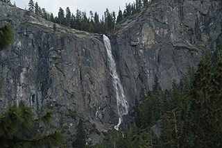
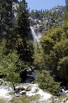
- 2005年06月19日 Silver Strand Fall
- 2005年06月18日 Tioga Road Update
- 2005年06月18日 ハーフドームのワイヤー&ステップ設置
- 2005年06月18日 Tioga Road除雪難航中
- 2005年06月18日 アメリカにおける自然保護政策
- 2005年06月17日 Museum前のジャイアントセコイア
- 2005年06月17日 タイオガロード状況
- 2005年06月16日 Yosemite Falls周辺の整備
- 2005年06月15日 Backpackingの予約状況
- 2005年06月15日 ヴァレービジターセンター&ブックストア
- 2005年06月14日 HISTORIC PARK PHOTOS
- 2005年06月14日 Yosemite Landscapes 1855-1991
- 2005年06月14日 ハイブリッド・シャトルバス
- 2005年06月12日 The Cascades
- 2005年06月11日 ヴァレー内交通規制
- 2005年06月10日 Missing in the Minarets
- 2005年06月10日 Tioga Road一部開通
- 2005年06月08日 雨模様
- 2005年06月07日 ミスト・トレイル
- 2005年06月06日 Mt.ホフマン
- 2005年06月06日 グレイシャーポイント周辺
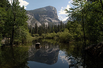
- 2005年06月05日 ミラーレイク
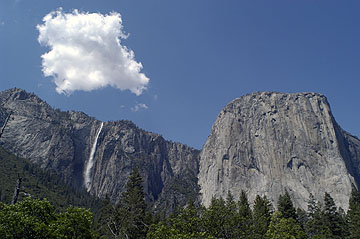
- 2005年06月04日 リボン・フォールとエルキャピタン
- 2005年06月03日 Tioga Road 一部開通間近
- 2005年06月01日 除雪作業、Olmsted Pt.に達する!
- 2005年06月01日 El Portal マネジメントファイアー
2005年06月29日
BUZZ OFF:蚊よけシャツ

一般論ですが、雪が多かった年のSierra Nevadaでは蚊が大発生します。先月末から(去年のREIの大安売りで手に入れた)ExOfficio社のBuzz Offシャツのフィールドテストをしてきました。結論:これはなかなか有効です! 蚊が近づいてきても、すぐに逃げ去っていきます。仕組みは簡単で、除虫菊系の(蚊の嫌う)成分が、繊維の中に含まれているためです。蚊には刺されたくない、といって蚊よけスプレーを使うのは臭くていやだという方には、お勧めです。服自体に臭いはありません。25回ほどの洗濯で効果がなくなるようですので、蚊のシーズン中、毎週末使ったとしても、2年は持ちそうです。私はキャンプ地での着替え、もしくはハイキング後の駐車場で使いました。
ちなみに投稿者はExOfficio社とは全く関係がありません。
YARTSバス(120号東線)の運行
7/1からヨセミテヴァレー〜マモスレイクス間のYARTSバス(120号東線)の運行が始まります。
The Yosemite Area Regional Transportation System (YARTS) will begin service on the Hwy 120/395 service corridor, between Mammoth Lakes and Yosemite Valley, on Friday, July 1st. ?Service in July and August is daily and there is one run per day in each direction. In September, the service is on weekends only.
As in the past, the Yosemite Valley bus will depart from the Valley Visitor Center at 5 PM, arriving in Tuolumne Meadows at approximately 6:45 PM and Mammoth Lakes at 8:50 PM, having made stops in Lee Vining and on the June Lake Loop.? The inbound trip leaves Mammoth Lakes at 7:00 AM and arrives in the Valley at 10:50 AM.
Please refer to the YARTS manuals distributed to Park information centers, however if you have questions regarding the service you can call the toll free phone at 1-888-899-2787 or Dick Whittington, YARTS Transit Manager, at 209-723-3153 x311.(D.Whittington - 6/28/05)
2005年06月27日
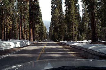
Tioga Road
さっそく通ってきてみましたが、かなり慎重にオープンを待っていたのか、
「情報操作だったの?」と思ってしまう程に、タイオガロード沿線の雪は少なかったです。
タイオガパス周辺以外にはまとまった雪を見る事は出来ません。
タイオガパス界隈も去年の開通直後の1/5以下といったところでしょうか。
雪だけでなく、川の水量もかなり少なくなっています。
沿線の各施設、分岐する道路はすべて閉鎖中ですが、
各道路はすでに除雪済みで、メイレイクもサドルバックレイクもすぐにオープンになるでしょう。
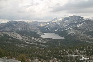
テナヤレイク方面
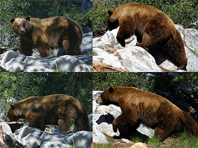
その他写真数枚以下にあります。(クマもようやくまともに撮れたかも)
http://www.flickr.com/photos/tioga/sets/506122
これ↓がそのクマちゃん。ヨセミテクリークの辺りにいました。距離5mくらい?
2005年06月24日
California Geological Survey
ヨセミテの黎明期に活躍したCalifornia Gelogical Survey(初代局長J. D. Whitney)ですが、今年で設立125年を迎えます。カリフォルニア州政府のウエブにページがあります。設立時のロゴはなかなかいいですね。ページの下には次のように書いてあります。
© 2005 State of California. Arnold Schwarzenegger, Governor. Conditions of Use Privacy Policy
2005年06月23日
クレジットカード情報流出事件
米国のクレジットカード情報流出事件で日本でも不正使用の被害が拡大しつつあるようです。
アメリカでのお買い物、ホテル等のWEBサイトでの予約などでカード決済をされている方は要注意らしいです。
今朝のテレビでは使用明細を昨年8月にさかのぼって確認したほうがいいということでした。
2005年06月22日
High Sierra Camp 閉鎖
San Jose Mercury新聞によると、yosemiteの5つのHigh Seirra Camp(Glen Aulin, May Lake, Sunrise, Vogelsang, Merced Lake)は、雪の為営業はしないとの事です。これらは、くじ引きで選ばれた4,300人の幸運な人しか宿泊できない、キャビンです。勿論自前のテントを持って行って泊るのはOKです。
Tuolumne Meadowsの売店、ガススタンド、グリルは7月1日より営業開始予定のようです。またWhitewolf、Tuolumneのロッジは7月8日からのようです。
衛星写真 by Google Maps
Google Mapsがベータ版で"Satellite"を提供しはじめています。
ヨセミテヴァレー周辺のものはこれです。
ヨセミテでの解像度はここまでですが、東京や米国の大都市部では場所によってはあと数段階上がります。一戸建てやクルマくらいまで写っています。例えば「自由の女神」とか、「新宿西口」とかこんな感じです。
Professional Paper 160 : 1930年
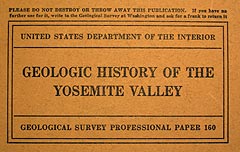
1865年、California Geological ServeyのJ. D. Whitneyは、地盤沈下によるヨセミテ渓谷の形成説を唱えました。Whitneyが発表した2年後の1867年には、William P. Blakeが渓谷は主に水による浸食で形成され、最後に氷河による浸食が入ったという説を唱えましたが、専門誌上で発表されたに過ぎず、一般の注目を浴びるには到りませんでした。一方、Whitneyの説は彼の一般向けの著作”The Yosemite Book”(1869年)や”Yosemite Guide Book”(1870年)によって有名になりました。Whitneyは、(Blakeの)氷河による浸食説を否定し、以前は認めていたヨセミテでの氷河の存在すらも否定するようになります。1871年、John Muirはヨセミテ渓谷が氷河のみの浸食によって形成されたという説を思いつきます。同年夏、Muirと共にヨセミテ・ハイシエラの旅行をしたU. C. Berkeleyの地質学者LeConteは、Muir説の氷河の浸食に、ある程度は同意しましたが、それ以前の水の浸食の影響も指摘していました。1874年、Muirは自身の研究の結果を雑誌に投稿し、それが一般の注目を浴びることになります(しかし後年には、カリフォルニア全土が氷河に浸食されたという極論を唱えるまでに到ります)。California Geological Serveyのメンバーでもあり、US Geological Survey(USGS)の初代所長となったClarence Kingは、氷河の流入があったことは認めるものの、その浸食の効果については殆ど無かったものとし、Whitneyのような地盤沈下の立場をとりました。他にも、多くの研究者たちが、それぞれの解釈や自説を発表します。例えば1899年にIsrael C. Russell(University of Michigan)は、氷河浸食説を否定し、Whitneyの地盤沈下説を支持しました。1899年にはHenry W. Turner(USGS)が、渓谷は岩の節理に働いた水による侵食と風化により形成されたもので、氷河の作用は殆どなかったと唱えます。また、同じUSGSのHenry Garnettは、氷河の侵食による形成説を唱えています。他にも多くの学者がそれぞれの説を唱えました。このように諸説が繚乱してまったのは、氷河や氷河流入以前の時代に関する、信頼のおける調査結果がなかったことにありました。1913年、シエラクラブなどの一般からの要求もあり、USGSはこの問題に決着をつけるために、ヨセミテ全域や周辺のハイシエラで、システマチックで徹底的な調査を開始する事にしました。その担当となったのは、主に岩の調査をしたFrank C. Calkinsと、氷河の歴史や、その浸食の進展について調べる事になるFrancois E. Matthesでした。長年にわたる調査の成果は、Matthesによりまとめられ、1930年にUSGSから”Geologic History of The Yosemite Valley:Geological Survey Professional Paper 160”というタイトルの論文として発表されました。これにより、60年にわたる論争に終止符が打たれることになりました。Matthes説の骨子は、広くなだらかな谷が形成されていたシエラ全体が数度にわたって隆起し、Merced Riverにより谷の浸食が進み、やがて深いV字谷が形成された事。そして、氷河期の到来で、そこに幾度かに渡って氷河が入りこみ、その浸食作用で、現在のように両側が垂直に切り立った渓谷が形成されたというものでした。その後の発見や調査結果により修正は加えられたものの、Matthesの説は現在でも、ヨセミテ渓谷の形成に関する通説として認められています。
写真:Professional Paper 160で使われている4枚??絵。オリジナル、もしくは類似の絵が、後に多くの書籍・ガイドブックなどで使われることになる。図説の年代は、Bill Guytonの”Glaciers of California”を使用。政府刊行物で特に著作権保護はされてないので、写真を掲載。論文で掲載されている写真の多くはUSGSのWebで閲覧する事ができる。
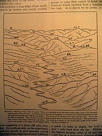
図1 :Broad Valley Stage - シエラネバダの隆起が始まる前のヨセミテには平らな谷が形成されていた。中央の山はHalf Dome。流れる川はMerced River。
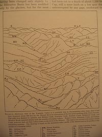
図2 : Mountain Valley Stage - 2500万年前ごろからシエラネバダの隆起が始まった。これによりMerced River沿いの谷が削られていく。
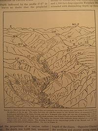
図3 : Canyon Stage - 150万年前:氷河が入る直前のヨセミテ渓谷。かなりV字谷化が進んでいる。
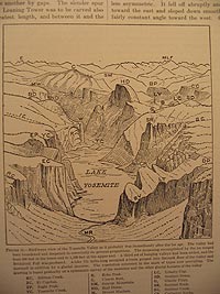
図4: 2万年前(三度目)の顕著な氷河浸食が終わったすぐ後のヨセミテ渓谷。現在の渓谷の形が出来上がった。渓谷にはLake Yosemiteが残っている。
ヨセミテ渓谷の形成に関して詳しい一般向け参考書:
*1 Bill Guyton ”Glaciers of California”,University of California Press,(1998)
*2 Jeffrey P. Schaffer,”The Geomorphic Evolution of the Yosemite Valley and Sierra Nevada Landscapes”,Wilderness Press,(1997)
*3 Mary Hill, ”Geology of the Sierra Nevada”,University of California Press,(1975)
*4 N. King Huber,”The Geologic Story of YOSEMITE National Park”, Yosemite Association (1989)
2005年06月19日
2005年06月18日
Tioga Road Update
On June 16, crews began to remove avalanche debris and snow from potential boulders from this rockslide near Olmsted Point.
過去ログ
4月15日
除雪開始
4月21日
Tioga Road April 21, 2005
Starting location: 4.3 miles East of Crane Flat
Ending Location: 4.8 miles East of Crane Flat
Distance plowed today: .5 miles
Snow depth: 11 feet
5月13日
Starting location: At White Wolf, 14 miles from Crane Flat Gate
Ending location: 14.5 miles from Gate
Distance plowed today: .5 miles
Snow depth is 15+ feet and getting deeper
Tioga Road progress for May 14, 2005
Starting location: 14.5 miles from Crane Flat Gate
Ending Location: 15.1 miles from Crane Flat Gate
Distance plowed: .6
Snow depth is 16 feet
May 16, 2005 10:57 PM
May 16th, all work on Tioga was suspended so crews could respond to the flood event in the Valley
May 17th.
Starting location: 15.1 miles from Crane Flat gate
Ending location: 15.6 miles from Crane Flat gate
Distance plowed today: .5 miles
Snow depth is 15 feet
Tioga Road progress May 21
Starting location: 20.6 miles from gate
Ending location: 22.2 miles from gate
Distance plowed: 1.6 miles
Snow depth: 6 feet
Tioga Road progress May 23
Starting location: 22.2 miles from gate
Ending location: 22.5 miles from gate
Distance plowed: .3 miles
Snow depth: 8 feet
Tioga Road progress May 24
Starting location: 22.5 miles from gate
Ending location: 25 miles from gate
Distance plowed today: 2.5 miles
Snow depth 4 feet
Tioga Road progress May 25
Starting location: 25 miles from Gate
Ending location: 25.8 miles from gate
Distance plowed today: .8 miles
Snow depth: 7 feet
Tioga Road report for May 26
Starting location: 25.8 miles from gate
Ending location: 26.6 miles from gate (May Lake Road)
Distance plowed today: .8 miles
Snow depth: 5 feet
No forward progress today (May 27). There was a substantial rock/mud slide in avalanche zone one. Slide was cleared by noon, however other emergency road repairs at several places throughout the park kept road crews busy the entire day.
Tioga Road report for May 31
Starting location: May lake turn-off
Ending location: Olmsted parking lot
Distance plowed today: 1.8 miles
snow depth: 4 feet
On June 1st, we will be preparing to cut through the Olmsted Avalanche zone. June 2nd, we intend to cut through the zone at Olmsted. Starting early, when there is a good freeze is imperative. Once we have cut through, the crews will go back west and let the snow takes its course. No work will be done for the rest of the day. An assessment will be done on Friday morning to see if it is safe for the crews to go through and proceed east.
Tioga Road report for June 2
Park crews were able to cut through the Olmsted avalanche zone today. After the cut, all personnel were sent back to work west of the zone while the avalanche team checks out the zone and waits the normal 24 hours to see if there will be any movement. If there is no activity, the crews will proceed eastward tomorrow.
Tioga Road report for June 4
Today, the crews were able to plow through avalanche zone 21 (Marmot Dome) and meet up with where the County left off. This does not mean that the road is opened. From Olmsted Point to Tuolumne Meadows, the road is plowed only a bit wider than one lane. Equipment failures have lead to this. We still need to widen these approximately 10 miles of road. We still have three active avalanche zones. In these areas, the road will remain only one lane wide until the zones are downgraded. The avalanche team believes Olmsted zone will probably remain a n avalanche zone for at least two more weeks. The road crews still need to plow out the administrative areas, widen the roadway, do ditching, road repairs, sweeping, and most of the signs along the road will need to be replaced. We still do not have a set opening date. We will be opening Segment 2, from Walker Party to Yosemite Creek, Thursday, June 9th.
Tioga Road report for June 14
Avalanche zones are still active on the Tioga Road. Park staff traveling on the road for administrative purposes are required to have avalanche training and equipment.
On June 14, crews began to remove boulders from this rockslide near Olmsted Point.
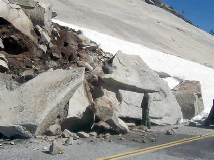
Tioga Road report for June 16
On June 16, crews began to remove avalanche debris and snow from potential boulders from this rockslide near Olmsted Point.
ハーフドームのワイヤー&ステップ設置
ハーフドームのワイヤー&ステップの今シーズンの設置作業がおわり、登山シーズンとなりました。
ただし今シーズンは頂上部分のトレイル補修が行われるので、7/4から10/4の月曜〜木曜:7時~
16時の間は通行止めとなりますのでご注意ください。
登山可能なのは金・土・日の終日です。月から木は16時以降、明朝7時までとなります。
The Half Dome cables are up for the season.
Please be aware that starting July 6th until October 4th, access to the summit of Half Dome will be limited due to closure of the Sub Dome segment of the Half Dome Trail for trail repair work. The work will require technical rigging (block and tackle) to move and place heavy stones on very steep terrain. The process is complicated and can be very hazardous to the trail crew employees and visitors without the closures. Please assist us on passing this information to other employees and park visitors.
Half Dome work schedule: July 6th to October 4th. CLOSED, Monday thru Thursday 7:00 AM to 4:00 PM.
OPEN (without restrictions) Friday, Saturday, Sunday, and in between the hours after 4:00 PM until 7:00 AM mid week. (J. Lopez - 6/17/05)
アメリカにおける自然保護政策
少し古いですが、面白い報告書があります。
http://www.clair.or.jp/j/forum/c_report/html/cr153/
追:ホワイトハウスはNPSの管理下にあるんですね。
2005年06月17日
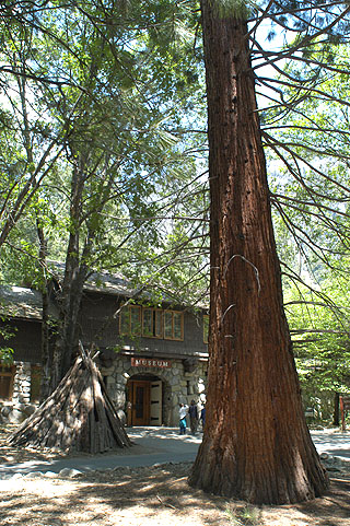
Museum前のジャイアントセコイア
ヨセミテでいちばん手軽にジャイアントセコイアが見られるのは、おそらくヨセミテヴァレーのMuseum(ヨセミテヴィレッジ内)前のものでしょう。
これは1930年に植えられたと書いてありますので樹齢は80年足らず。マリポサグローブの樹齢数千年のものと比べるとだいぶん迫力には欠けますが、「どうしてもジャイアントセコイアを見たい」という方はとりあえずこれを見に行ってはいかがでしょうか。
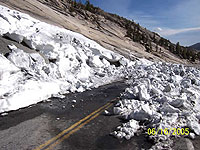
タイオガロード状況
なかなか難航しているようで、いまだ開通予定日は発表されません。
除雪作業状況の頁では、オルムステッドポイント付近の落石の写真が出ていました。
センターライン付近まで巨石が落ちています。作業ご苦労様です。
NPSによる写真
On June 14, crews began to remove boulders from this rockslide near Olmsted Point.
2005年06月16日
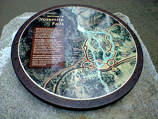
Yosemite Falls周辺の整備
約2年間かけてのYosemite Falls周辺の整備が完成し、今シーズンからオープンしています。従来の駐車場の自然復元とトイレの新築、トレイル、ベンチや案内板などです。
2005年06月15日
ヴァレービジターセンター&ブックストア
今シーズンから、ヴァレービジターセンター&ブックストアが模様替えしています。
建物はそのままですが、従来の場所にはレンジャーとYA(Yosemite Association)のボランティアスタッフによる案内カウンターのみとなり、ブックストアは建物正面の左側部分(以前はツアー案内窓口だったところ)に移動しました。
従来は狭いところに案内カウンターとブックストアのレジが同居していて、わかりにくく混雑時にはよく混乱していました。今回の模様替えでより分かりやすく、またブックストアのほうも繁盛(!?)するようになったのではないでしょうか。
ちなみにYA会員はここで15%オフで買い物ができます。その他にも特典がありますので、リピーターの方はぜひ入会しましょう。手続きも簡単です。
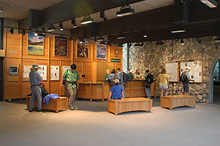
「案内カウンター」
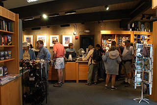
「繁盛しているYAのブックストア」
2005年06月14日
HISTORIC PARK PHOTOS
USGSのサイトで昔の国立公園写真が公開されています。ヨセミテも886枚あります。
http://libraryphoto.er.usgs.gov/parks1.htm
HISTORIC PARK PHOTOS AVAILABLE ON-LINE:
The on-line system of the United States Geological Survey Photographic Archive provides access to over 25,100 photographs dating from 1868 through 1992. There are 886 historic photos specifically of Yosemite. Be patient though--even with a high speed connection the complete set of thumbnails can take upwards of 5 minutes to load. Try using the "Free Form" search to narrow down your subject. To access the photographic archive go to http://libraryphoto.er.usgs.gov/parks1.htm. These photos are not copyrighted and may be viewed and downloaded free of charge. All photos are available in 100, 700 and 1400 dots per inch resolution. The collection emphasizes Geology, Earthquake Damage, National Parks and Monuments. (C. Palmer - 6/6/05)
Yosemite Landscapes 1855-1991
"Yosemite Landscapes 1855-1991"展がヴァレーのMuseum Galleryで開催されています。9月30日まで。 10 - 12 am, 1-4 pm。
Yosemite Landscapes 1855-1991 in the Museum Gallery through September 30, features a selection of landscape paintings and drawings from the park's museum collection from the earliest representations of the valley by Thomas Ayres through the work of contemporary artists. Albert Bierstadt's "Night at Valley View" is on exhibit for the first time in several years, after conservation treatment and reframing through the generosity of the Yosemite Fund. The gallery is open daily, 10 - 12 am, 1-4 pm. (B. Beroza - 6/13/05)
ハイブリッド・シャトルバス
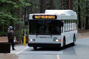
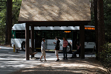
ミラーレイク・トレイルヘッドのバス停にて
今シーズンよりお目見えした新型のシャトルバスです。ガソリンエンジン+バッテリー+電気モーターのハイブリッドシステムを搭載して燃費と排気ガス性能が向上しています。
また主要バスストップも屋根付き工事が完了しています。
2005年06月12日
2005年06月11日
ヴァレー内交通規制
昨日ヴァレーから戻りました。
ヴァレー内はいたるところで道路工事をやっていて、ヨセミテヴィレッジ〜センチネル橋間が通行止めでした。そのためにカリービレッジ〜ヨセミテヴィレッジ間で恒常的に渋滞が発生していて、これには参りました。
YOSEMITE VALLEY ROADS (Various Repair Locations--Most of the work will occur at various areas on Southside Drive and Northside Drive between Bank 3-way and Camp-6 intersection)
June 6th thru June 10th Continue Microseal (Were trying to keep the delays under 15-minutes when we are working on the 2-way road sections. Most of the Southside Drive work will occur between El Capitan Crossover and Swinging Bridge, as well as at the south end of the Sentinel Bridge. We'll also be working again on Northside Drive between Bank 3-Way and Camp-6 and possibly a few other areas (work in the other areas is dependent upon how work progresses throughout the week). No further microseal work is scheduled after June 10th.
***June 8th thru June 10th Microseal one lane of Northsdrive between El Captian Crossover and Pohono Bridge - one lane of traffice will remain open at all times.
June 13th and beyond There may be some asphalt overlay and patching work in a few small areas at various locations throughout the summer
During 6:00 AM to 8:00 AM and 4:00 PM to 6:00 PM (commuter hours) Monday thru Friday, the delays will be kept to 15-minutes maximum. Also, the hours of work with 30-minute delays may vary from day to day depending upon the weather and traffic conditions
SOUTH FORK BRIDGE REPLACEMENT
June 6th thru June 10th Complete Bridge Demolition (This may be a bit optimistic, but they are planning to have the majority of the bridge demolition completed on June 10th--however they are planning to leave parts of the piers for the new bridge falsework support) (There may be some minimal delays moving equipment and trucks in and out of the site.)
June 13th thru June 17th Begin excavation and formwork for the new abutments.
2005年06月10日
Missing in the Minarets
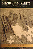
1933年7月末、サンフランシスコの若手弁護士Peter Starr(Walter A. Starr Jr.)は、単独で2週間のシエラネバダへ探査に出かけました。当時Peterは完成したばかりのJohn Muirトレイル、及びシエラの山々のガイドブックを作っていました。8月7日に、パリセード山群近くのGlacier Lodgeで待ち合わせをしていたPeterの父Walterは、予定日を数日経ってもやってこない息子に何かが起きたと確信し、捜索願いを出しました。やがて、Peterの車がMammoth Lakes近くのAgnew Meadowsで発見されます。目撃証言から、Peterが付近で遭難した可能性が高まります。そして、Ediza Lakeをベースキャンプにし、Ritter-Banner-Minaret山群で、当時の有名な登山家Norman ClydeやEichorn、Dawsonらも含む大規模な捜索が開始されました。PeterがMt. Ritterに残したメモや、アイゼン、ピッケル、カメラなどがベースキャンプそばで見つかったものの、Peterの行方は依然わからず、やがて捜索は打ち切られることになります。Norman Clydeは、あきらめずただ一人山に残り、単独でMinaret付近での捜索を続け、ついに8月25日にPeterの遭難現場を発見しました。そして、そのニュースはメモリアルサービスを準備中のStarr家に、当日夜遅く伝えられました。
当時の(綺麗な)モノクロ写真、関係者へのインタビュー、詳しい調査に基づいて書かれたドキュメンタリーです。山の遭難というと暗いイメージが思い浮かびますが、そのような感じを全く与えない、すばらしい本に仕上がっています。遭難から一年後、Peterの遺稿は父Walterの手により仕上げられ、”Starr's Guide to the John Muir Trail and the High Sierra Region”として発行され、その後多くの人々に愛用されるようになりました。
Missing in the Minarets
The Search for Walter A. Starr, Jr.
William Alsup著
Yosemite Association出版
ISBN: 1-930238-18-5 (softbound)
ISBN: 1-930238-08-8 (hardbound)
Tioga Road一部開通
The Tioga Road is open from Crane Flat to Yosemite Creek (no access to Tuolumne Meadows or US 395). No overnight parking permitted.
2005年06月08日
2005年06月07日
ミスト・トレイル
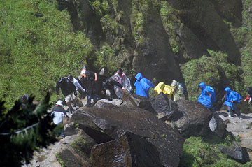
6/7のミストトレイルです。天気は快晴ですが、カッパやポンチョの行列です。雨具なしの強者もいましたが冷たい飛沫を浴びますので結構無謀な感じ。
しかし、どうやっても濡れますので、ヴァーナル滝上ではみな服を乾かしています。
2005年06月06日
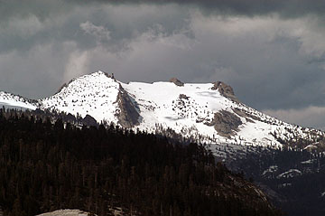
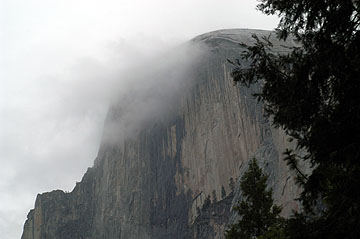
グレイシャーポイント周辺
6月6日でこれだけの雪がありました。
タイオガロードの東の方ではまだこれよりも沢山残雪があることでしょう。
「グレイシャーポイント駐車場」2005.6.6
「グレイシャーポイントロード」2005.6.6
2005年06月05日
2005年06月04日
2005年06月03日
Tioga Road 一部開通間近
とりあえず、東と西からの除雪区間が片側一車線でつながったようです。
From Olmsted Point to Tuolumne Meadows, the road is plowed only a bit wider than one lane. Equipment failures have lead to this. We still need to widen these approximately 10 miles of road
ヨセミテクリークまでの一部開通が始まります。
We will be opening Segment 2, from Walker Party to Yosemite Creek, Thursday, June 9th.
詳しくはこちら
過去ログ
4月15日
除雪開始
4月21日
Tioga Road April 21, 2005
Starting location: 4.3 miles East of Crane Flat
Ending Location: 4.8 miles East of Crane Flat
Distance plowed today: .5 miles
Snow depth: 11 feet
5月13日
Starting location: At White Wolf, 14 miles from Crane Flat Gate
Ending location: 14.5 miles from Gate
Distance plowed today: .5 miles
Snow depth is 15+ feet and getting deeper
Tioga Road progress for May 14, 2005
Starting location: 14.5 miles from Crane Flat Gate
Ending Location: 15.1 miles from Crane Flat Gate
Distance plowed: .6
Snow depth is 16 feet
May 16, 2005 10:57 PM
May 16th, all work on Tioga was suspended so crews could respond to the flood event in the Valley
May 17th.
Starting location: 15.1 miles from Crane Flat gate
Ending location: 15.6 miles from Crane Flat gate
Distance plowed today: .5 miles
Snow depth is 15 feet
Tioga Road progress May 21
Starting location: 20.6 miles from gate
Ending location: 22.2 miles from gate
Distance plowed: 1.6 miles
Snow depth: 6 feet
Tioga Road progress May 23
Starting location: 22.2 miles from gate
Ending location: 22.5 miles from gate
Distance plowed: .3 miles
Snow depth: 8 feet
Tioga Road progress May 24
Starting location: 22.5 miles from gate
Ending location: 25 miles from gate
Distance plowed today: 2.5 miles
Snow depth 4 feet
Tioga Road progress May 25
Starting location: 25 miles from Gate
Ending location: 25.8 miles from gate
Distance plowed today: .8 miles
Snow depth: 7 feet
Tioga Road report for May 26
Starting location: 25.8 miles from gate
Ending location: 26.6 miles from gate (May Lake Road)
Distance plowed today: .8 miles
Snow depth: 5 feet
No forward progress today (May 27). There was a substantial rock/mud slide in avalanche zone one. Slide was cleared by noon, however other emergency road repairs at several places throughout the park kept road crews busy the entire day.
Tioga Road report for May 31
Starting location: May lake turn-off
Ending location: Olmsted parking lot
Distance plowed today: 1.8 miles
snow depth: 4 feet
On June 1st, we will be preparing to cut through the Olmsted Avalanche zone. June 2nd, we intend to cut through the zone at Olmsted. Starting early, when there is a good freeze is imperative. Once we have cut through, the crews will go back west and let the snow takes its course. No work will be done for the rest of the day. An assessment will be done on Friday morning to see if it is safe for the crews to go through and proceed east.
Tioga Road report for June 2
Park crews were able to cut through the Olmsted avalanche zone today. After the cut, all personnel were sent back to work west of the zone while the avalanche team checks out the zone and waits the normal 24 hours to see if there will be any movement. If there is no activity, the crews will proceed eastward tomorrow.
Tioga Road report for June 4
Today, the crews were able to plow through avalanche zone 21 (Marmot Dome) and meet up with where the County left off. This does not mean that the road is opened. From Olmsted Point to Tuolumne Meadows, the road is plowed only a bit wider than one lane. Equipment failures have lead to this. We still need to widen these approximately 10 miles of road. We still have three active avalanche zones. In these areas, the road will remain only one lane wide until the zones are downgraded. The avalanche team believes Olmsted zone will probably remain a n avalanche zone for at least two more weeks. The road crews still need to plow out the administrative areas, widen the roadway, do ditching, road repairs, sweeping, and most of the signs along the road will need to be replaced. We still do not have a set opening date. We will be opening Segment 2, from Walker Party to Yosemite Creek, Thursday, June 9th.
Tioga Road report for June 14
Avalanche zones are still active on the Tioga Road. Park staff traveling on the road for administrative purposes are required to have avalanche training and equipment.
2005年06月01日
除雪作業、Olmsted Pt.に達する!
やっとOlmsted Pointに達しました。
Tioga Road report for May 31
Starting location: May lake turn-off
Ending location: Olmsted parking lot
Distance plowed today: 1.8 miles
snow depth: 4 feet
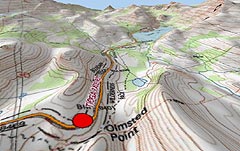
Olmsted Pt.よりTenaya Lake方面: NPS Webの地図
El Portal マネジメントファイアー
今週、El Portalの裏山(Gas Standの裏付近)で64エーカーのマネージメントファイアーが予定されています。一日だけで終了の予定で、特に交通規制はしないようです。
El Portal Prescribed Burn Notification
May 31, 2005
The National Park Service announces plans to conduct an El Portal
Prescribed Burn this week in Yosemite National Park, weather and air
quality conditions permitting.
This burn is being conducted in mostly grass with scattered brush near the
Old El Portal community and is approximately 64 acres. The objective of
this burn is critical community protection in the grasslands surrounding
Old El Portal. Fire managers hope to create a break in the grasses that
can fuel a destructive fire under hot, dry conditions.
A series of prescribed burns near El Portal have provided fuel breaks that
help firefighters make a safer stand against wildfire. Some of these burns
helped firefighters with community protection during the Woodlot Fire two
years ago.
This burn should be a one day operation and residents should not expect
smoke to continue beyond that day.
Smoke impacts to the roadway may occur, so please use caution when driving
in and around the burn area where smoke, fire vehicles, equipment, and
personnel may be present.
For further information: Yosemite’s Fire Information Office: