2005年05月 アーカイブ
- 2005年05月29日 ヴァレー厩舎オープン
- 2005年05月27日 マリポサグローブ
- 2005年05月27日 ハーフドーム
- 2005年05月27日 Merced Riverの水量
- 2005年05月26日 Glacier Point Road 開通!
- 2005年05月26日 108号開通!
- 2005年05月26日 Tioga Road 除雪状況
- 2005年05月23日 5/21-22のYosemite
- 2005年05月23日 除雪状況(続)
- 2005年05月23日 108号(Sonora Pass)開通予定日発表
- 2005年05月21日 Half Dome
- 2005年05月18日 規制解除
- 2005年05月17日 洪水警報!
- 2005年05月16日 White Wolf
- 2005年05月15日 トレイル状況
- 2005年05月12日 Glacier Point Road除雪状況
- 2005年05月12日 TUOLUMNE MEADOWSの積雪
- 2005年05月11日 ゴールデンウィーク
- 2005年05月07日 Mariposa Grove Roadオープン!
- 2005年05月05日 Tioga Road 除雪状況
- 2005年05月03日 GAS price
- 2005年05月02日 Topo! 地図ソフト
- 2005年05月01日 Access Yosemite
2005年05月29日
ヴァレー厩舎オープン
ヴァレーのStables(厩舎)がオープンしています。乗馬ツアーのプログラムが始まります。
The Valley Stables will open for the season on Saturday, May 28, 2005 (K. Tucker - 5/27/05)
2005年05月27日
マリポサグローブ
マリポサグローブへの大型車の通行規制が解除され、ワワナからのシャトルバスの運行も5/26から始まりました。またトラムのツアーも始まるようです。
The Mariposa Grove Road will be open to buses, including park shuttle buses, beginning on Thursday, May 26, 2005. Wawona shuttle service to the Grove will begin on Thursday afternoon. DNC will announce the beginning of MG trams. (T. Ludington & K. Tucker - 5/25/05)
ハーフドーム
ハーフドームのワイヤーケーブルは6/16に張られると発表されました。
Half Dome Cables will be up by Thursday, June 16, 2005, weather permitting. (T. Ludington - 5/25/05)
2005年05月26日
Glacier Point Road 開通!
NPS web site
The Tioga Road is closed for the winter. It usually reopens in late May or early June, however a wet winter and spring will result in a later opening than usual.
All other park roads, including the Glacier Point Road, are open.
108号開通!
CalTransでは108号の規制がなくなっています。
SR 108
[CENTRAL CALIFORNIA & SIERRA NEVADA]
NO TRAFFIC RESTRICTIONS ARE REPORTED FOR THIS AREA.
[EASTERN SIERRA NEVADA]
NO TRAFFIC RESTRICTIONS ARE REPORTED FOR THIS AREA.
4、5日前は以下の状況でした。
SR 108
[CENTRAL CALIFORNIA & SIERRA NEVADA]
IS CLOSED FROM 26.4 MI EAST OF STRAWBERRY TO 5.3 MI WEST OF THE
JCT OF US 395 /SONORA PASS/ (TUOLUMNE,MONO CO's) - WINTER CLOSURE -
MOTORISTS ARE ADVISED TO USE AN ALTERNATE ROUTE - THE ESTIMATED DATE
OF REOPENING IS 5/27/05
26.4M地点はSonora Passへの上り口。
Tioga Road 除雪状況
ウエブサイトに地図が出ました。
メイレイクへの分岐地点近くまで来ています。次の目標はOlmsted Pointですね。
Tioga Road progress May 24
Starting location: 22.5 miles from gate
Ending location: 25 miles from gate
Distance plowed today: 2.5 miles
Snow depth 4 feet
過去ログ
4月15日
除雪開始
5月13日
Starting location: At White Wolf, 14 miles from Crane Flat Gate
Ending location: 14.5 miles from Gate
Distance plowed today: .5 miles
Snow depth is 15+ feet and getting deeper
Tioga Road progress for May 14, 2005
Starting location: 14.5 miles from Crane Flat Gate
Ending Location: 15.1 miles from Crane Flat Gate
Distance plowed: .6
Snow depth is 16 feet
May 16, 2005 10:57 PM
May 16th, all work on Tioga was suspended so crews could respond to the flood event in the Valley
May 17th.
Starting location: 15.1 miles from Crane Flat gate
Ending location: 15.6 miles from Crane Flat gate
Distance plowed today: .5 miles
Snow depth is 15 feet
Tioga Road progress May 21
Starting location: 20.6 miles from gate
Ending location: 22.2 miles from gate
Distance plowed: 1.6 miles
Snow depth: 6 feet
Tioga Road progress May 23
Starting location: 22.2 miles from gate
Ending location: 22.5 miles from gate
Distance plowed: .3 miles
Snow depth: 8 feet
Tioga Road progress May 24
Starting location: 22.5 miles from gate
Ending location: 25 miles from gate
Distance plowed today: 2.5 miles
Snow depth 4 feet
Tioga Road progress May 25
Starting location: 25 miles from Gate
Ending location: 25.8 miles from gate
Distance plowed today: .8 miles
Snow depth: 7 feet
Tioga Road report for May 26
Starting location: 25.8 miles from gate
Ending location: 26.6 miles from gate (May Lake Road)
Distance plowed today: .8 miles
Snow depth: 5 feet
No forward progress today (May 27). There was a substantial rock/mud slide in avalanche zone one. Slide was cleared by noon, however other emergency road repairs at several places throughout the park kept road crews busy the entire day.
Tioga Road report for May 31
Starting location: May lake turn-off
Ending location: Olmsted parking lot
Distance plowed today: 1.8 miles
snow depth: 4 feet
On June 1st, we will be preparing to cut through the Olmsted Avalanche zone. June 2nd, we intend to cut through the zone at Olmsted. Starting early, when there is a good freeze is imperative. Once we have cut through, the crews will go back west and let the snow takes its course. No work will be done for the rest of the day. An assessment will be done on Friday morning to see if it is safe for the crews to go through and proceed east.
2005年05月23日
5/21-22のYosemite
〇洪水後であちこちに水溜りがありました。マーセッド川を渡るトレイルで閉鎖されているものもありました。(ヨセミテロッジとセンチネルミドウの間(スインギングブリッジへ行くトレイル)など)
〇水の増加で観光客も増加し、土曜日は(日曜日も?)、Village方面への車の進入が規制されてました。
エルキャピタンの下のところ(ワヲナ道路から下りてきてエルキャピタンの方へ曲がるところ)で、
園内宿泊施設の予約の有無をチェックされ、無い車は左へ、ある車は右へと振り分けられました。
無い車の多くはそこら辺の道路脇に車を停めて歩いて入っていくようで、とにかく酷い渋滞でした。
〇長らく閉鎖中だったノースサイドドライブが使えるようになりました。(土曜から?)
閉鎖のままでは来週の連休にはとんでもないことになっていたでしょうから良い事です。
〇ハーフドームの雪はこの一週間でもかなり融けていましたがまだかなり残っています。
ケーブルはおそらく雪が溶けるまでセットアップされないのでしょう。
(従って今回はハーフドームは泣く泣くあきらめて、クオータードームに登りました)
〇ネヴァダ・ヴァーナル滝はものすごい水量になっていてミストトレイルでの濡れ方は半端ではありません。
下着までずぶ濡れになりました。しかも普段はミストではないヴァーナル滝から上でも濡れました。
除雪状況(続)
公式サイトによるとグレイシャーポイントロードは5/27の開通予定のようです。
タイオガロードはまだ未定です。除雪作業がんばれー!
The Tioga Road is closed for the winter. It usually reopens in late May or early June, however a wet winter and spring may result in a later opening than usual. The Glacier Point Road is also closed; the projected opening is May 27, 2005, conditions permitting.
108号(Sonora Pass)開通予定日発表
CalTransによると、5月27日に開通予定のようです。現在は上り口(26.4M地点)でクローズ。
SR 108
[CENTRAL CALIFORNIA & SIERRA NEVADA]
IS CLOSED FROM 26.4 MI EAST OF STRAWBERRY TO 5.3 MI WEST OF THE
JCT OF US 395 /SONORA PASS/ (TUOLUMNE,MONO CO's) - WINTER CLOSURE -
MOTORISTS ARE ADVISED TO USE AN ALTERNATE ROUTE - THE ESTIMATED DATE
OF REOPENING IS 5/27/05
2005年05月21日
Half Dome
最近のハーフドームハイキングの時の写真をwebにアップしたので
興味のある方はどうぞ。整理の都合で複数に分割していますが、
とりあえず今月のと去年の9月のとを置いてます。
気が向いたらその他の回や他の写真も追々追加するかもしれません。
2005年5月
http://www.flickr.com/photos/tioga/sets/355279/
http://www.flickr.com/photos/tioga/sets/355427/
2004年9月
http://www.flickr.com/photos/tioga/sets/357688/
http://www.flickr.com/photos/tioga/sets/357460/
2005年05月18日
規制解除
マーセド川の異常水位によるヴァレー内の通行規制は2005年5月17日午前6時30分頃(現地時間)に解除されました。
今回ヴァレーでの最高水位はおよそ11フィート6インチ(16日午後5時頃)だったようです。
・道路の破損は、いまのところ大丈夫なようです。
・ノースパインキャンプ場の一部サイト、ハウスキーピングキャンプの一部ユニットが破損しているようです。
毎度のことですが「洪水はヨセミテの自然のプロセスです」と書かれています。
みなさんもご理解ください。
May 17, 2005
Re-Opens Roads reopen in Yosemite Valley
Roads in Yosemite Valley were re-opened at approximately 6:30 AM on May 17, 2005. Initial assessments indicate that roadways were not damaged during yesterday's high water.
Campsites are currently being assessed for damage; those which have not sustained any damage should open by noon today. It is possible that some campsites in the North Pines Campground have sustained damage, and Yosemite National Park officials recommend that campers with reservations in North Pines call for information before coming to the park.
Additionally, some units in Housekeeping Camp have been damaged; those which have not will be open by noon today. Visitors with reservations in Housekeeping Camp should call Delaware North Company, Inc., at 559/252-4848 for information about their reservation. All other lodging and camping facilities in Yosemite Valley are open with no restrictions.
High water levels peaked at about 11 feet, 6 inches in Yosemite Valley at about 5:00 PM. Water was crossing both Southside Drive and Northside Drive in places from multiple sources including Bridalveil Creek, Ribbon Creek, and the Merced River.
Flooding is a natural process in Yosemite National Park. High snow levels this winter, combined with unsettled spring weather patterns, indicate that flooding may occur. Visitors are advised to check the web site www.nps.gov/yose , or call 209/372-0200 for current weather conditions
2005年05月17日
洪水警報!
雪解け水によりヨセミテ渓谷内はマーセド川の水位が異常に高くなっており、現在入場はできなくなっています。
状況と写真はこちら
http://www.nps.gov/yose/news/highwater/
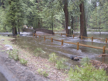
(Yosemite Creek Footbridge, May 16, 2005 NPS撮影)
May 16, 2005 (morning)
Yosemite Valley temporarily closed
High water is causing flooding in some Yosemite Valley areas, including campgrounds, parking areas, some lodging facilities, and picnic areas. Larger than usual snowpack, warm weekend weather, and rain have all contributed to higher than usual water levels.
Safety concerns, including road flooding and possible infrastructure damage, have prompted Yosemite National Park officials to close Yosemite Valley temporarily to traffic. In addition, all East Valley campgrounds are closed until further notice.
Other areas in Yosemite National Park, including Wawona and areas off of Highway 120 west including Big Oak Flat and the Merced and Tuolomne Groves of Giant Sequoias will remain open until further notice. Glacier Point Road and Highway 120 East (Tioga Road) are still closed.
Visitors are advised to check weather and road conditions before coming to Yosemite National Park. Information can be obtained at 209/372-0200 or on the park website at www.nps.gov/yose. Visitors with lodging reservations should contact Delaware North Company, Inc., at 559/ 252-4848 to check on current conditions.
2005年05月16日
White Wolf
6月に複数件WhiteWolfのテントキャビンを予約していたのですが、
DNCから電話があって、オープンしないのでキャンセルしてほしい
(あるいは日をずらしてバレーの部屋に代えてほしい)
との連絡がありました。聞いてみたところWhiteWolfのオープンは
今のところ7/1の予定だそうです。それまでにタイオガロードが全通しているか
どうかはわかりませんが、少なくとも7/1にWhiteWolfまでは行けるようです。
2005年05月15日
トレイル状況
NPSによるトレイル状況がアップされていました。
主な情報は
ヴァーナル/ネヴァダ滝トレイル ○
ハーフドーム頂上のワイヤー+ステップ作業はメモリアル・デー(5月最終月曜)を目標
4マイルトレイル 下部の2マイルまでオープン(未だ途中まで)
ミラーレイクループ 一部作業区間あり
ヨセミテ滝トレイル ○
それから公園内各地のトレイルで雪解け水で川の水位が上昇している(とくに今年は多い)ので、渡河するのが危険な箇所が多数あるようです。ご注意を。
Trail Conditions Update - The Vernal/Nevada Falls trail complex will be completely opened by Thursday morning for foot traffic. The trail will not be available for stock for perhaps another week or so until the trail is fully cleared of trees and the small snow banks that still exist in shaded areas. There is approximately 20-30% snow cover in Little Yosemite Valley. It is hoped the Half Dome cables will be up for Memorial Day, but that is weather dependent.
The lower 2 miles of the 4 Mile Trail are open. The trail on the south side of the Mirror Lake loop was damaged by a large fallen tree, but trail crews are currently working on it, and it should be repaired in a few weeks. It is passable on foot, but not with stock. The Yosemite Falls Trail is completely open for foot traffic, although some snow patches exist at the top. The Snow Creek switchbacks should be clear of snow to the top. The loop across to the Yosemite Falls Trail may be difficult to follow due to snowy sections, and is not recommended yet.
Hikers might consider trails out of the Hetchy area toward Beehive or Rancheria, or out of Wawona toward Chilnualna Falls. High water challenges have already been seen by hikers, including flooding on trails and difficult creek crossings. Hikers should be extremely careful regarding high water this year, as many creeks may be hazardous to cross well into the summer. Although any crossing can be dangerous, Tamarack and Cascade Creeks on the Old Big Oak Flat Road trail, Bluejay Creek upstream from Yosemite Falls, and the crossing above Chilnualna Falls camping area are "close-in" areas which are commonly very difficult in high water. (L. Boyers - 5/12/05)
2005年05月12日
Glacier Point Road除雪状況
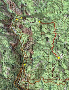
二日前(10日)で、7.4マイルほどの除雪を終えています。あと25%を残すだけです。まだ正式発表はありませんが、月末のメモリアルウイークエンド開通を目指しているのでしょうか(かなり難しそうですが)。黄色点:左手前はTunnel View、右はBadger Passのスキー場(除雪開始点)。奥は左からCurry Village、Glacier Point、除雪到達地点。東は上側。
11日の状況がUPされています。8.4マイル地点です。除雪終了のあとすぐには開通しませんが、なんとなく5月末開通ができそうな気配です。
金曜日(13日)の状況です、SUYAMAさんのコメントのように駐車場まで達しました。まだ開通の予定日は出ていません。
Glacier Point:
We are now at the parking lot. Although we are at the Glacier Point parking lot, there is still a lot of work to be done before any traffic can be allowed to Glacier Point. We have to widen the road (cut back the snow banks), trim trees sticking out into the roadway, road repair, ditching, and all of the sign work. We also need to plow out all the turnouts and access roads.

Valleyの俯瞰:赤い点は、手前左からSentinel Dome、Glacier Point駐車場、Curry Village、Vernal Fall、 Nevada Fall。奥はYosemite Falls、 Mirror Lake、Half Dome(北は上側)。
TUOLUMNE MEADOWSの積雪
NPSによれば、TUOLUMNE MEADOWSでは五月に入ってのべ4日で14インチ(約35センチ)の新雪があり、積雪は5/10現在、50インチ(約127センチ)あるそうです。
TUOLUMNE MEADOWS - WINTER CONDITIONS UPDATE - May 10, 2005
(last one of the season)
WEATHER: (from May 2 to May 10)
High temp: 55° (May 3)
Low temp: 17° (May 7)
New snow: 14” (May 5, 6, 7, 9 & 10)
Total settled snow depth: 50” (May 10)
2005年05月11日
ゴールデンウィーク
BBSのほうで、ゴールデンウィークや週末にヨセミテを訪問された方々の報告をいただいています。
未だ雪が降るという天候だったようですが、みなさん楽しんでこられたようで、よかったです。
2005年05月07日
Mariposa Grove Roadオープン!
公式サイトのConditions Updateによると、5/6の16時の更新から
Mariposa Grove Road (open to cars/SUVs only):Open
となっていました。
(この表記だと普通車とSUVはOK。大型RVやバスは未だ通れないということなのでしょう。)
2005年05月05日
Tioga Road 除雪状況
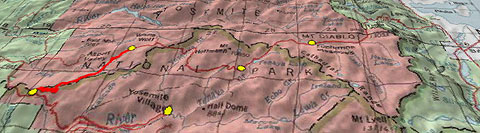
4月19日ごろに始まったTioga Roadの除雪は、昨日Crane Flatから12マイル地点まで達しました。White Wolfまでもうすぐです。去年は4月末に除雪は終わり、5月15日には開通でした。今年はかなり遅れそうです。Tioga Road上の黄色点は左からCrane Flat、 5/3の除雪到達点、Olmsted Point、Tuolumne Meadows。手前はYosemite Valley。
2005年05月03日
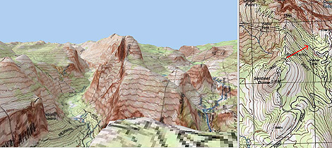
2005年05月02日
Topo! 地図ソフト
National Geographic社の地図ソフトTopo!に、やっと3次元表示モードが追加されました。上は、Yosemite AssociationのSentinel Domeカメラの位置から見たHalf Dome方面です。使い方は、2次元モードでポイントを設定してから?3次元表示モードに変換、方向、高度、俯角等を変え、リアルタイムで表示するものです。