2011年06月 アーカイブ
- 2011年06月26日 ヨセミテ:6月25日
- 2011年06月25日 Yosemite Waterfalls June 2011
- 2011年06月19日 ヨセミテ:6月18日
- 2011年06月18日 ハーフドーム登頂開始は6月22日から
- 2011年06月17日 タイオガロード開通は18日(土)午前8時
- 2011年06月16日 Tioga Road除雪
- 2011年06月12日 ヨセミテ: 6月11日
- 2011年06月10日 キャンプ場予約システムについての変更
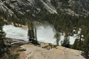
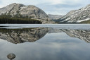
2011年06月26日
ヨセミテ:6月25日
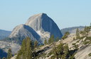
Olmsted Pt.からのHD
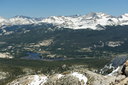
Tuolumne Meadows全景。下流(左)側は完全に水没。左端中段やや下の岩はPothole Dome。最高峰はConness。
南側斜面の雪線(写真奥)は9500ft.付近。北向きの斜面では9000ft.といった感じです。
Cathedral Lakesへのトレイルですが、THから歩き始めてすぐ雪に遭遇します。
Lakes一帯は完全に雪に覆われています。湖面の雪が融けるのはあと1週間といった感じでしが、トレイルから雪が消えるのには、あと2週間はかかると思われます。
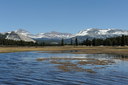
冠水したTuolumne Meadowsから見るMt. Dana(左)、Gibbs(中央)、Mammoth Peak(右)。
意外にも雪が少ないDanaの上部。1998年の大雪の年は、7月4日でも真っ白でした。
反対側Pothole Dome(右側)方面。
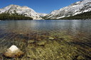
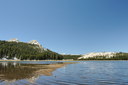
すっかり雪が消えてしまったTenaya Lake。なんとなく夏の雰囲気。
Yosemite Creekの西側の道路沿いで、わずかですがMountain Prideが咲き始まりました。
2011年06月25日
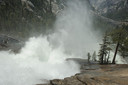
Yosemite Waterfalls June 2011
yosemitephoto氏が、Youtubeに動画「Yosemite Waterfalls June 2011」をアップされました。雪解けの最大水量で、すごい迫力ですね。
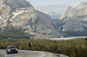
2011年06月19日
ヨセミテ:6月18日
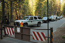
開門50分前。8時には40台ほどの車が並びました。
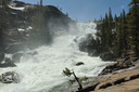
Tuolumne滝
Waterwheel滝
LeCone滝

Tuolumne Meadowsは冠水状態。
まだ雪が浮いていたTeneya Lake。あと1週間で融けそうな感じ。
Olmsted Pt.よりTenaya Lake。
2011年06月18日
ハーフドーム登頂開始は6月22日から
ハーフドーム登頂開始は6月22日からです。
今シーズンの登頂は事前予約が必要です。
Yosemite National Park Announces Half Dome Cables in Place on Wednesday, June 22
http://www.nps.gov/yose/parknews/hdcablesup.htm
2011年06月17日
タイオガロード開通は18日(土)午前8時
タイオガロード開通は18日(土)午前8時とNPSのサイトに掲載されました。
http://www.nps.gov/yose/parknews/tiogaopens611.htm
2011年06月16日
Tioga Road除雪
The Tioga Road will open on Saturday, June 18, 2011, at 8 am. There will be several no-stopping zones and visitors should be aware that hiking opportunities are extremely limited due to snow and dangerous creek crossings. No services will be available along the road.
http://www.nps.gov/yose/planyourvisit/tioga.htm
http://www.nps.gov/yose/planyourvisit/tiogaopen.htm
Beginning Friday, June 10, the Tioga Road will be open to bicycles from Crane Flat to Olmsted Point. There will be no access beyond Olmsted Point due to the avalanche zone just east of Olmsted Point. From the east, the road is open to bikes from US 395 to the west end of Tuolumne Meadows. It will be signed accordingly. Please be on the lookout for debris falling into the road and administrative vehicles travelling back and forth.
全線をとりあえず除雪したようですが、開通には最低でも2週間はかかりそうですね。
下のリンクに新しい写真が入っています。
The Tioga Road has been partly plowed for its entire length. Now, road crews are working to remove snow from the entire width of the road and plow turnouts and side roads. In addition, road crews will be removing rockslides and redirecting snowmelt across the road to reduce icy road conditions. Finally, Olmsted Point is still unsafe due to avalanche danger.
The Tioga Road is now open to bicycles from Crane Flat to Yosemite Creek Bridge. Please watch out for debris on the road and road crew traffic. If conditions allow, we will extend the bicycle zone farther east prior to the opening.
The Glacier Point Road opened on Friday, May 27, 2011.
The Tioga Road is now open to bicycles from Crane Flat to Yosemite Creek Bridge. Please watch out for debris on the road and road crew traffic. If conditions allow, we will extend the bicycle zone farther east prior to the opening.
Olmsted Pt.の斜面ははすでに越えています。
Last Update: May 26, 2011
Tioga Road: Crews are working east from Olmsted Point. Mono County & Mammoth Mountain crews are working between Marmot Dome and Spring hill.
The Glacier Point Road opens at noon on Friday, May 26, 2011.
Last Update: May 25, 2011
Tioga Road: Crews are working near Olmsted Point.
Additionally, as of May 20, Mono County Public Works and Mammoth Mountain crews have plowed to 3.8 miles from Tioga Pass. Mammoth Mountain is using snowcats to expedite the process.
Last Update: May 23, 2011
Tioga Road: Yesterday, crews plowed from May Lake to May Lake Pit. Snow depth is 15 feet or deeper.
Additionally, as of May 20, Mono County Public Works and Mammoth Mountain crews have plowed to 3.8 miles from Tioga Pass. Mammoth Mountain is using snowcats to expedite the process.
Glacier Point Road: The road has been plowed, but additional work is required before the road can open. There is no estimated opening date. (The road usually opens by the end of May.)
Last Update: May 20, 2011
Tioga Road: Yesterday, crews plowed to Porcupine Creek Trailhead (two miles from previous point).
Additionally, Mono County Public Works and Mammoth Mountain crews have begun plowing from the east side and are now at Mono/Parker Pass Trailhead.
Glacier Point Road: The road has been plowed, but additional work is required before the road can open. (See photos below the map.) There is no estimated opening date. (The road usually opens by the end of May.)
Last Update: May 19, 2011
Tioga Road: Yesterday, crews plowed the Big Oak Flat Road due to new snowfall, plowed 18-20 inches of new snow on the Tioga Road, then plowed 0.4 miles from previous point (now at Porcupine Summit). Snow depth is 11 feet.
Additionally, Mono County Public Works and Mammoth Mountain crews have begun plowing from the east side and are now at Mono/Parker Pass Trailhead.
Glacier Point Road: No update. Last update: Crews worked on widening along the Glacier Point Road and clearing in the parking lot. Snow depth in the lower lot is 3 to 4 feet and the upper lot is 4 to 7 feet. Next week, crews will begin plowing the trail between the parking lot and the point.
Last Update: May 17, 2011
Tioga Road: Yesterday, crews plowed 0.8 miles and went through an avalanche zone at Yosemite Creek hill.
Glacier Point Road: No update. Last update: Crews worked on widening along the Glacier Point Road and clearing in the parking lot. Snow depth in the lower lot is 3 to 4 feet and the upper lot is 4 to 7 feet. Next week, crews will begin plowing the trail between the parking lot and the point.
Last Update: May 16, 2011
Tioga Road: Yesterday, crews started at Yosemite Creek and ended at an avalanche zone, plowing 1.6 miles. Crews will attempt to go through the avalanche zone today, conditions permitting.
Glacier Point Road: No update. Last update: Crews worked on widening along the Glacier Point Road and clearing in the parking lot. Snow depth in the lower lot is 3 to 4 feet and the upper lot is 4 to 7 feet. Next week, crews will begin plowing the trail between the parking lot and the point.
Last Update: May 13, 2011
Tioga Road: No update. Previous update: Rotary plows have reached the Siesta Lake area just past the 8,000 foot elevation mark. Snow depths average 10 feet in depth. Charcoal has been spread over Olmsted Point to aid the melting of the snow above the road. Crews will work Monday through Saturday.
Glacier Point Road: Crews worked on widening along the Glacier Point Road and clearing in the parking lot. Snow depth in the lower lot is 3 to 4 feet and the upper lot is 4 to 7 feet. Next week, crews will begin plowing the trail between the parking lot and the point.
やっとSiesta Lakeの近くに到達しました。雪が一番深い地帯(White Wolfの東側)にはまだいたっていません。
Last Update: May 9, 2011
Tioga Road: Rotary plows have reached the Siesta Lake area just past the 8,000 foot elevation mark. Snow depths average 10 feet in depth. Charcoal has been spread over Olmsted Point to aid the melting of the snow above the road. Crews will work Monday through Saturday.
Glacier Point Road: Dozers have plowed off enough snow that the rotary blowers are to Washburn Point. Work will continue Monday through Thursday working down through the switchbacks to the parking lot. Average snow depth is still eight feet.
Mariposa Grove: The road is open; all weight restrictions have been removed.
2011年06月12日
ヨセミテ: 6月11日
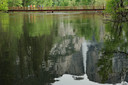
依然(?)、冠水ぎりぎりのSwinging Bridge。
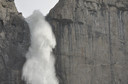
トレイル中段部より見る、ヨセミテ滝の落ち口
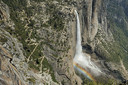
Eagle Pointより見るヨセミテ滝。
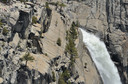
ヨセミテ滝展望台付近。
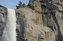
Bridalveil Fall。
2011年06月10日
キャンプ場予約システムについての変更
園内のキャンプ場予約に関しての変更が3点通知されています。
1.6/8以降、チェックインの際にIDカードの提示しての本人確認が求められる。(予約した名義とチェックイン本人との照合の厳密化)
2.6/8以降、一旦予約した氏名を変更することはできない。(一旦キャンセルし、新規に別の名前で予約する必要)
3.キャンセル分の予約は、オンライン・システムでは公開されず、電話でのみ予約が可能となる。(夏シーズン後半以降に適用)
原文はこちらです。
Yosemite National Park Announces Changes to the Campground Reservation System
http://www.nps.gov/yose/parknews/recgovchanges.htm