2010年05月 アーカイブ
- 2010年05月31日 ヨセミテ:5月30日
- 2010年05月27日 Glacier Point Road
- 2010年05月21日 ハーフドーム登頂開始はしばらく延期
- 2010年05月21日 HD Trail
- 2010年05月14日 Wilderness Conditions
- 2010年05月12日 トレイル状況
- 2010年05月09日 ヨセミテ: 5月8日
- 2010年05月07日 ルック・アメリカンツアー
- 2010年05月02日 ヨセミテ: 5月1日
2010年05月31日
2010年05月27日
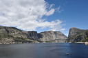
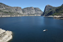
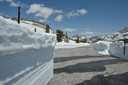
Glacier Point Road
Glacier Point Road:
The Glacier Point Road will open on Friday, May 28 at noon, conditions permitting. Expect 30-minute delays between Chinquapin and Badger Pass Sunday night through Friday afternoon (except Memorial Day).
Tioga Road:
The Tioga Road will not be open for Memorial Day weekend; there is no estimated opening date.
Plows have reached Tioga Pass and will now be working on widening the road. Plowing continues Monday - Saturday. Average Snow Depth is 4 to 6 feet. Plowing operation will continue today.
2010年05月21日
ハーフドーム登頂開始はしばらく延期
toshiさんが下に投稿してくださってますが、まだ残雪が多いためハーフドーム登頂開始はしばらく延期です。今週末と来週末の登山パーミッションを持っている方は返金だそうです。
HD Trail
The Half Dome cables
2010年05月14日
Wilderness Conditions
Trails Update:
The Mist and John Muir Trails to Vernal and Nevada Falls are now open.
May 2010
Notices
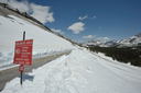
Both the Tioga and Glacier Point Roads are currently closed. Plowing operations are underway but there is no estimated opening date for either road. For more information on the plowing progress, please visit: http://www.nps.gov/yose/planyourvisit/tioga.htm.
Please note that Tioga Road is closed in its entirety, from one mile east of Crane Flat to five miles west of US 395 and is not open to the progress of the plows.
Additionally, if the Glacier Point Road opens for the season prior to May 28, it will be open Saturdays and Sundays only through May 27 (plus Friday, May 21) due to road work. Delays may occur after May 28, but the road will be open seven days per week.
Trail Conditions
Even though it maybe spring on the calendar, it still feels like winter throughout much of Yosemite. A series of late-season storms have increased the winter snow pack to about 140% of average for this time of year. Snow will be present on trails above 6,000 ? 7,000 feet depending on the aspect. Generally forested and shaded areas as well as north and east facing slopes hold snow later in the year than more open areas.
Expect wet and muddy trails throughout the park. Please stay on the existing trails to limit resource damage and trail erosion. Always take caution crossing snow banks as they may be hollow or undercut. In addition, navigation may be difficult over snow covered areas as trails are not marked on trees, so be prepared and know how to use a map and compass.
With warmer temperatures creeks and rivers are running high. Use caution when crossing or fording creeks. Some creek levels may fluctuate with the day’s temperature; a creek that was passable in the morning may not be so in the afternoon.
Trails out of Yosemite Valley
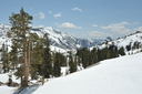
Little Yosemite Valley is mostly snow-free with just a few patches of snow. The trail to Cloud’s Rest is snow free up until the 7,500 ft contour and then is 100% snow covered. The trail up the Merced River is mostly clear with patchy snow until the twin bridges area, after which there is significant snow coverage.
Trails are mostly clear to the top of the valley rims via the Yosemite Falls or Snow Creek trails. However, once past the valley rims, the trails quickly become completely covered with snow. Other trails leading to the valley rims will be free of snow until about 6,500 feet and then quickly become 100% snow covered.
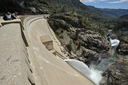
Trails out of Hetch Hetchy
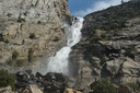
Rancheria Falls is open and clear; though expect to get wet from the spray from the base of Wapama Falls. Furthermore, the crossing from Tueeulala Falls is high so use caution when crossing. Continuing from Rancheria Falls, the trail is clear to Tiltill Valley which is completely flooded.
The trail to Beehive meadows is clear to within about a mile of the meadow, and then is 100% snow covered. Additionally, Frog Creek is very high and is especially difficult to cross. Access to Laurel Lake or Lake Vernon is therefore limited and not recommend at this time.
Trails out of Wawona
The trail up to Chilnualna Falls is clear. However, trails beyond the falls have 100% snow coverage.
Wilderness Center Hours
Yosemite Valley
Open 7 days a week from 8:00 a.m. until 4:30 p.m
Bear Canisters are available for rent as well as a wide selection of maps and books.
Big Oak Flat
Opens for the year on May 14, 2010, 8:00 a.m. to 4:30 p.m. Thereafter, it will be open 7 days a week with bear canisters available for rent as well as a wide selection of maps and books. Before May 14, wilderness permits are available by self-registration. This year, self-registration will be available at the campground office due to construction on the information station.
Wawona
Open 7 days a week from 8:30 a.m. until 5:00 p.m
Bear Canisters are available for rent as well as a wide selection of maps and books.
Tuolumne Meadows
The Tuolumne Meadows Wilderness Center is closed until the Tioga Road opens for the season. Self-registration permits are available at the ski hut.
Hetch Hetchy
Hetch Hetchy road hours are 7:00 a.m. to 9:00 p.m daily. Permits and canisters may be obtained during open hours. There is no access to Hetch Hetchy past open hours.
Wilderness Permit Reservation Line
Permit reservations can be made 24 weeks to the day in advance of your starting date. The phone line is open Monday-Friday, 8:30 am to 4:30 pm at 209/372-0740. For trip planning, general information and online permit reservations please visit our website http://www.nps.gov/yose/planyourvisit/backpacking.htm or the interagency website http://www.sierranevadawild.gov/.
Food Storage
Bear Resistant Food Canisters are required in all parts of the Yosemite Wilderness. Use a bear resistant food canister to store all food or scented items when left unattended. Whenever food or scented items are out, please keep them within arms reach, even while day hiking.
If a bear approaches your camp, act immediately to scare it away. Maintain a safe distance while making as much noise as possible. Throw small stones or pines cones toward the bear, being careful not to strike the bear on the head. If the bear returns, repeat. Do not attempt to retrieve food or gear from a bear until it abandons the items.
2010年05月12日
トレイル状況
HDケーブルは月末まではUPしないようです。
# The Half Dome cables will not be in place over the May 21-23 permit period. Snowpack in the Yosemite high country is currently well above average (134% in the Merced River basin), with the potential for additional cool, wet weather in the next week. As a result, the Half Dome cable route and subdome are covered in deep snow, making trail conditions poor. For the safety of National Park Service employees setting up the cables and for hikers, the cables will not be put up until conditions improve. We will monitor conditions over the next two weeks and issue an expected opening date as soon as possible. If you have a permit for May 21-23, you will receive a refund for the reservation fee.
(Learn more about the Half Dome hike. Please note that permits are required to hike to Half Dome on Fridays-Sundays and holidays beginning this year.)
# The Mist Trail from near Vernal Fall Footbridge to the top of Vernal Fall (and to Nevada Fall) is open. The John Muir Trail between Clark Point and the Panorama Trail (near the top of Nevada Fall) is closed for the season.
# The Four Mile Trail to Glacier Point is closed for the season at Union Point (no access to Glacier Point).
# The southern portion of the Mirror Lake Loop is closed due to a rock fall. (Access to Mirror Lake and Snow Creek Trail is still available, as usual.) Learn more about the rockfall.
# The trail to Wapama Falls is closed to stock (but is open to hikers) beyond the Beehive junction due to a rock fall.
2010年05月09日
ヨセミテ: 5月8日
Olmsted Point。雪面の高さは2メートル弱くらい。
すでに除雪は雪崩危険地帯を突破、Tenaya Lake近くまで進んでいます。此処でNPSの職員の方に出会い、色々と聞いてみましたが、月末開通は微妙な感じでした。
Clouds RestとHalf Dome。
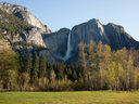
朝のヨセミテ滝。
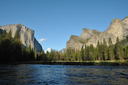
かなり水量が増え、2週間前には立てた川岸の岩は水没していました。
2010年05月07日
ルック・アメリカンツアー
「ルック・アメリカンツアー」のJTB Travel Network 様が、「ヨセミテ国立公園大好き!」の2010夏シーズンのスポンサーをしていただけることになりました。
ページの上部にバナー広告が表示されます。サンフランシスコやロスアンゼルスから出発するヨセミテ国立公園行きツアー、ヨセミテヴァレーから出発するオプショナルツアー等のご案内です。