2006年09月 アーカイブ
- 2006年09月28日 JMT Record Attempt (by Al Shaver)
- 2006年09月28日 Tioga Roadでの夜間駐車は禁止:10月15日より
- 2006年09月27日 TMキャンプ場閉鎖
- 2006年09月25日 USGSプレゼンテーション:Clarence King
- 2006年09月19日 YAの会員特典
- 2006年09月17日 Olmsted Pt.リニューアル
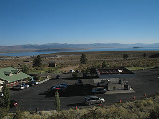
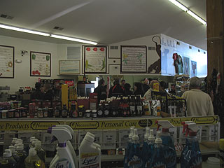
- 2006年09月17日 Lee Vining Mobil Gas Station
- 2006年09月10日 Olmsted Point
- 2006年09月10日 Stanley Albright
- 2006年09月08日 Campground closuresなど
- 2006年09月05日 Laurel Fire [2]
- 2006年09月03日 A Rival of Yosemite: 1891年6月
- 2006年09月02日 140号 常時開通
- 2006年09月01日 Camp4−El Capitan間のシャトルサービス
2006年09月28日
JMT Record Attempt (by Al Shaver)
つい1週間前、Al Shaver氏(49才)がJMT(全長211マイル)をサポートなしで踏破する記録に挑戦した模様ですが、すでに二度失敗したようです。明日は三度目のスタートをするそうです。詳しい記事とステータスはここにあります。現在サポートなしでの記録は、Reinhold Metzger氏(当時61歳)の5日と7時間だそうです。サポート付きでは3日と21時間のようです(Kevin Sawchuk氏)。
報告が遅れましたが、三度目も失敗してしまいました。残念です。来年がんばってほしいです。断念したのは金曜日、エスケープ地点はForester Pass付近。そこから26マイルを歩いて車に乗せてもらったようです。たぶんBubbs Creek経由でKings Canyonに降りたと思われます。詳しいレポートが入ったらまた報告します。ちなみにForester Passは高度13,000+ft.で、ここをこの季節夜中の11時に歩いて(走って)いるというのは驚きです。
”Al called to say that after running all night (he hit Forester Pass at 11 p.m.), at 6 a.m. Friday, he decided to quit the JMT and head out to the west. Blisters were making every step painful, intestinal critters were making themselves known, and he had "bonked." However, he still had 26 miles to hike out to a road, which had virtually no traffic. Finally, he caught a ride to Fresno where he slept at a motel. He is now ultralight backpacking in the city and trying to get a ride up to Yosemite Valley to his car. He enjoyed hearing me read your enthusiastic and supportive comments over the phone. He plans to stay high while he's still acclimated and do some short hikes if he's able. Thanks to all,
Janet”
Tioga Roadでの夜間駐車は禁止:10月15日より
ということで、Tioga Road上に車を止めてのBackpackingは不可になります。もちろんハイキング(日帰り)のための駐車は可能です。またHDケーブルも同じ頃Downします。
Effective on October 15 there is no overnight parking anywhere on the Tioga Road between Crane Flat and Tioga Pass. This includes all pullouts, turnouts, parking lots, and side roads in Tuolumne Meadows and along the Tioga Road. In addition there will be no bus service or any other facilities available along the Tioga Road after October 1. Be fully prepared for everything you will need on your hike, including either being picked up or dropped off on the Tioga Road. In addition after the 15th be prepared for the possibility that the Tioga Road may be closed due to snow and you will have to hike to another road or developed are that is open.
The Half Dome cables are set to be taken down on October 16, 2006. They will remain down all winter and are usually put back in place in the week before Memorial Day Weekend.
2006年09月27日
TMキャンプ場閉鎖
TMキャンプ場は昨日で閉鎖しました。 Tioga Road上でまだ開いているのは、Porcupine FlatとTamarack Flatだけです(10月15日まで)。
Campground closure: Today 9/25/06 the Tuolumne Meadows campground closes for the season. Wawona campground will be available starting today on a first come first serve basis, the group campsite in Wawona continues on reservations year round, and the stock campsites are closed for the season. Porcupine Flat and Tamarack Flat remain open on a first come first serve basis until October 15th. (S. Ogden - 9/25/06)
2006年09月25日
USGSプレゼンテーション:Clarence King
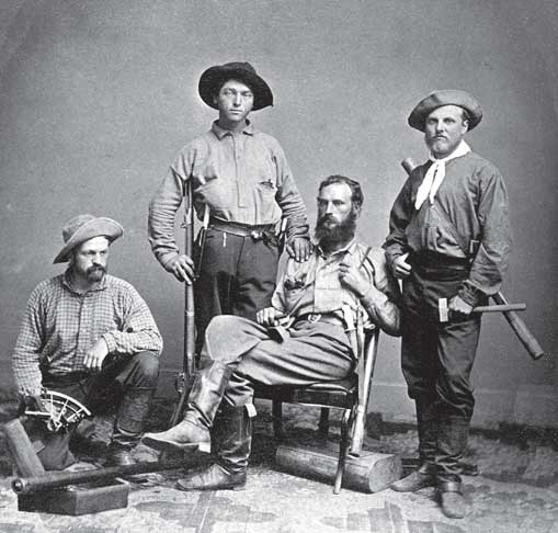
写真:The 1864 field party of the California Geological Survey (Charles Hoffmann absent). From left to right: James T. Gardner, Richard D. Cotter, William H. Brewer, and Clarence King. Gardner is holding a sextant used for mapping and astronomical location; Cotter is armed with musket, dagger, and pistol; both Brewer and King have mercury barometers - used to measure altitudes - slung on their shoulders; and King holds a geologist's hammer. (U.S. Geological Survey Library)
あまりヨセミテは登場しませんが、USGSの面白いプレゼンテーションビデオを見つけました。
タイトルは”Mapping the American West: Clarence King and the 40th Parallel Survey”で、スピーカーはJames G. Moore氏(Geologist)です。 時間は約50分。1863年の夏、California Geological Survey(Whitney隊)のHoffmannとBrewerらはヨセミテでの測量を行いました。その時Mt. Hoffmann、Danaへ登頂しますが、Mt. Lyellへは不成功に終わります。その後Mono Lake、Sonora Pass、Carson Pass、Lake Tahoeを越えてSacramentoに戻ったBrewerは、San Franciscoへ向かう蒸気船に乗船し、そこでYale大学を出て間もないClarence KingとJames Gardinerに出会います。
氏の話はそこから始まり、一行のLassen Peakを始めとするカリフォルニア北部の探査(1863)、1864年の南シエラ(現在のKings、Sequoia NP、Inyo NF)と制定されたばかりのヨセミテ渓谷州立公園での測量、1867年からKing自らが率いたアメリカ西部・北緯40度付近での測量(the 40th Parallel Survey)について触れられます。そしてMt. ShastaやWhitney登山の逸話のあと、USGSの設立(Kingは初代所長)で話が結ばれています。
[註]話は変わりますが、文献から推察できるように、MuirはWhitney隊の記録をかなり意識していました。Tuolumne渓谷、Kings渓谷、Middle Fork Kings River、Mt. Ritter、Mt. Tyndall、Mt. Whitney、Mt. Shasta、ヨセミテの氷河(跡)、セコイアの群生などと、隊が調査・指摘・登山しようとした場所をことごとく追いかけています(Tyndallは間違った山を登りましたが)。
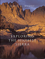
このビデオに関連した氏の著作は:”Exploring The Highest Sierra”(2000年、Stanford University Press)と”King of the 40th Parallel”(2006年、Stanford University Press)があります。前者は、南シエラの探検と地質学の2部構成といえます。総400+ページ。昔の地図、写真、絵などが多様され、見るだけでも楽しめます(後編は岩、造山などの話になり、少々退屈します)。
2006年09月19日
YAの会員特典
Yosemite Associationのメンバーシップを更新しました。(International会員。$50/年)
今回の会員証と一緒に以下のものが同封されてきました。
会員特典説明書
・公園内および近隣のブックストア、ビジターセンターの販売物15%割引
・YA主催「Outdoor Adventure」の参加費15%割引
・アンセルアダムスギャラリーの販売物10%割引
・公園内および近隣の宿、ツアーの割引
その他詳細はここ参照
割引クーポン
・アワニーホテル宿泊(259ドルで。2007.1/2-3/29週末除く)
・ヨセミテロッジ宿泊20%割引(2006.11/1-2007.3/29週末除く)
・テナヤロッジ宿泊20%割引(2006.11/1-2007.3/29週末除く)
・ワワナホテル宿泊10%割引(2006.3/26-12/14週末除く)
・バジャーパススキー場のリフト券1名分価格で2名分。(2007シーズン)
・ヴァレーフロアツアー1名分価格で2名分。(2006.12/31まで)
・ワワナゴルフコース1名分価格で2名分。(2006.11/1まで)
2006年09月17日
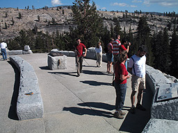
Olmsted Pt.リニューアル
つい先日リニューアルがすんだOlmsted Pt.も大賑わいでした。
Park Shuttleバスは、TMから30分おきにOlmsted Pt.までサービスしています。
2006年09月10日
Olmsted Point
だいぶリニューアルの工事が進んでいます。テナヤ渓谷周辺のブロンズ製立体模型(写真:1メートル四方くらい)が置いてありました。Half Domeが見えるでしょうか?
模型台が小さく見えています。
Stanley Albright
投稿が遅れましたが、42年間NPS職員として働き、1997-2000年の間ヨセミテ国立公園の公園長であったStanley Albright氏が8月18日に亡くなられました。ご冥福をお祈りします。
Albright氏はNPSの創設期にStephen Mather長官とともに国立公園制度そのものを作り上げたHorace Albrightの甥にあたります。
Albright氏は全米10以上の国立公園の誕生に関わり、最後はヨセミテ国立公園の公園長として引退されました。
追悼記事
http://www.sfgate.com/cgi-bin/article.cgi?f=/c/a/2006/08/23/BAGF5KNDR61.DTL
2006年09月08日
Campground closuresなど
いよいよキャンプ場が閉まり始めました。夏も終わりです。
*Campground closures: Bridalveil Creek Campground and Yosemite Creek Campground have closed for the season. (M. Carter - 9/6/06)
*The Hetch Hetchy Road Day Use Hours are 8:00 AM to 7:00 PM. (C. Flores - 9/6/06)
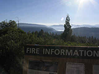
鎮火に伴うトレイルの再開
Yosemite Fire Information Update #23
September 03, 2006
The following trails have been reopened. Hikers should continue to use caution while traveling through these areas and be aware of possible hazards. The immediate fire area remains closed for hiker safety. Please stay out of the fire perimeter and areas that have active fire.
- The historic Great Sierra Wagon Road (between White wolf and Aspen Valley)
- Tamarack Flat to El Capitan Trail including the Old Big Oak Flat Road
- The Hetchy switchbacks to the Beehive Trail
- The Beehive Trail to Laurel Lake
- The northern loop trail of Laurel Lake
2006年09月05日
2006年09月03日
A Rival of Yosemite: 1891年6月
Muirの歩いたシエラネバダ(続き)
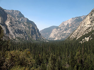
1891年5月28日、Muirは画家のRobinsonと共にSan Franciscoを出発し、Kings渓谷と出来たばかりのGeneral Grant及びSequoia National Parkへと向かいます。これは1873年10月、1875年7月、そして1877年10月の旅行に続き、Muirにとって4度目の訪問となります。日記[1]によると、5月30日にGeneral Grant National Parkを訪ね、6月1日にはKings渓谷へと下り、そこで2週間近くをすごしています。Robinsonと共に渓谷沿いの岩山(Second Sentinel)に登ったこと、出会った少年が熊をしとめた話、帰るときに増水した川にミュールが落ち、それを助けたことなどのエピソードが書かれています。Muirは渓谷の様子について克明な記述を残しており、そこがヨセミテ渓谷とかなり似た形状をしていると書いています[2]。MuirはここでYosemiteという言葉をヨセミテ渓谷のような形状の谷と一般化し、The Kings River Yosemiteと使っています。
さてMuirは同年11月、Century誌に”A Rival of Yosemite: The Canyon of the South Fork of King's River, California”[2]という記事を掲載します。これはKings渓谷の概略、アプローチ、渓谷景観の詳細な記述、過去4回の自分の探査行などをRobinsonの描いたスケッチと共にまとめたものです。78ページ目(記事の第2ページ)には、出来たばかりのSequoia National Parkの地図があり、そこにKings渓谷を含む広大な一帯を追加する提案がされています[3]。日記と”A Rival of Yosemite”を読み比べると、後者ではかなり自然保護を訴えていることに気づきます。また日記では淡々と書きとめた熊狩りの話ですが、動物愛護風の書き方に変わっています。
写真:Kings渓谷の上半分を上流から望む。
参考:
[1]"John of the Mountains: Unpublished Journals of John Muir"(Linnie Marsh Wolfe編)
[2]6月1日のエントリーは、渓谷の様子について詳しく書いています。しかしWolfeは脚注で、オリジナルの日記が判読不明なためCentry誌の記事を使って代用したと書いています。注意して読み比べると、数行を除いて完全なコピーとなっています。
[3]"Remembered Yesterdays"(Robert Underwood Johnson著)によると、1891年5月にJohnsonは、Muirに依頼して作らせたKings渓谷付近の地図を内務省長官Nobleに送り、その一帯を保護区とするように提案しています。Muirは常日ごろ、ヨセミテ渓谷よりKings渓谷のほうがよりすばらしいと主張していたとの事です。 ”May, 1891, I sent him a sketch map which at my request Muir had made of the Kings's River Canyon region to support my proposal that a large reservation should be made to include that gorge, which Muir always asserted was more wonderful than the Yosemite.” これにNobleは8月28日に返信し、Kings渓谷をSequoia NPに組み込む件は、機会があったら大統領に尋ねてみると返答しています。 ”It will greatly please me to bring the additional reservation for the Sequoia National Park before the President as soon as an opportunity is afforded. The necessary legislation will also be asked.”
2006年09月02日
140号 常時開通
Highway 140 Ferguson Rock Slide Bypass Open 24 Hours A Day
(Mariposa County) The Department of Transportation (Caltrans) is opening Highway 140 to 24 hour traffic. Beginning September 1, 2006 the two bridge temporary bypass installed to move motorists around the rock slide will be open to one-way controlled traffic 24 hours a day.
Due to roadway restrictions, vehicles over 28 feet in length are not allowed on the bypass. The oneway bypass will be controlled by traffic signals. ### (B. Boswell, CALTRANS - 9/1/06)
11/5にヨセミテを訪れた際に、助手席乗車だったので写真を撮ってきました。(suyama)
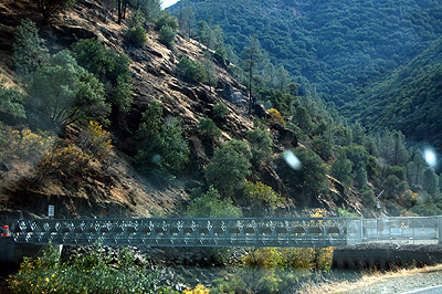
下流の橋
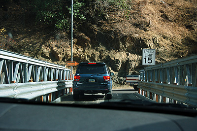
下流の橋上
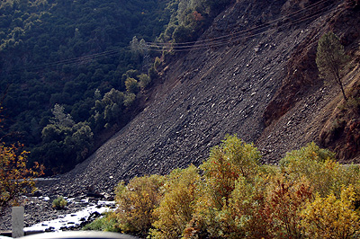
崩落部分1 (埋まった部分の両側に道路(本来のCA140)も見えます)
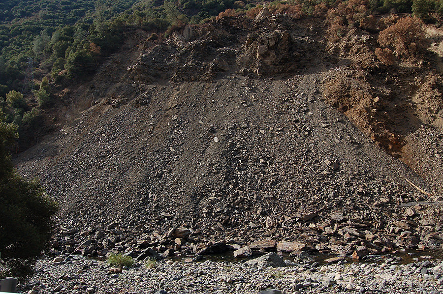
崩落部分2 (アングルが違うだけです)
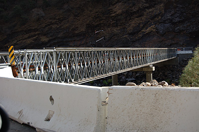
上流の橋
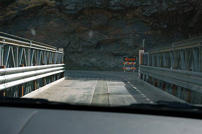
上流の橋上
2006年09月01日
Camp4−El Capitan間のシャトルサービス
Camp4からEl Campitanの麓までのシャトルサービスがあるようですね。地図には出ていないそうです。
The El Capitan Shuttle is now stopping at Camp 4 so that it can be more useable to the many climbers who stay at this campground. This stop is on the north side of North Side Drive near the old gas station area, not at the Valley Shuttle Camp 4 stop. The new stop does not show up on the maps yet, so it will be up to all of us to get the word out to visitors, especially those staying at Camp 4. Shuttles operate daily from 9 am to 6 pm, leaving every hour and half hour from the Visitor's Center and will arrive at Camp 4 shortly after the hour and half hour. The last bus leaves the Visitor Center at 6 pm.
Since this service has been well used and the El Capitan climbing area is very popular in September, the El Capitan Shuttle has been extended through the 1st of October. It is hoped that the addition of the Camp 4 stop and the extension of service will benefit visitors as well as reduce the number of vehicles parked at the El Capitan area. Further extension to this service will be considered if ridership remains high through September. (W. Malone - 8/31/06)