News2005 アーカイブ
- 2005年12月29日 「ヨセミテ渓谷、ヨセミテ国立公園に編入」 100周年目
- 2005年12月23日 Conditions Updateより
- 2005年12月21日 Yosemite Association Holiday Sale
- 2005年12月10日 Yosemite in Time
- 2005年12月02日 Winter Closure
- 2005年11月29日 マリポサグローブのギフトストア営業終了
- 2005年11月28日 High Sierra 嵐の後
- 2005年11月28日 Hetch-Hetchy Day Use Parking Pass
- 2005年11月23日 Tioga Pass Cam が yosemite.org とLINK
- 2005年11月21日 まだまだいけますHigh Sierra
- 2005年11月16日 Mariposa Grove
- 2005年11月16日 Tioga Road
- 2005年11月16日 アワニー メドウ CAM
- 2005年11月12日 Tioga Gas Mart
- 2005年11月01日 キャンプ場営業終了
- 2005年10月29日 Tioga Road 再再開通
- 2005年10月28日 Tioga Road再閉鎖
- 2005年10月27日 落石@Curry
- 2005年10月25日 Tioga Road : 一時閉鎖 =>開通
- 2005年10月22日 ヨセミテヴァレーの火入れ
- 2005年10月19日 Porcupine Flatキャンプ場営業終了
- 2005年10月19日 グレイシャーポイントのトイレ工事
- 2005年10月18日 no overnight parking
- 2005年10月16日 Backpacker誌 2005年12月号
- 2005年10月15日 ハーフドーム・今シーズン閉山
- 2005年10月12日 キャンプ場営業終了
- 2005年10月12日 Tuolumne Groveの一時閉鎖
- 2005年10月09日 オルムステッド・ポイントのプロジェクト
- 2005年10月05日 メイレイクのトイレ
- 2005年10月02日 煙のシーズン
- 2005年09月28日 Tuolumne Meadowsキャンプ場営業終了
- 2005年09月27日 ハーフドーム・トレイル工事
- 2005年09月20日 Gas
- 2005年09月18日 White Wolfキャンプ場営業終了
- 2005年09月16日 Climber Falls from Half Dome
- 2005年09月14日 シーズン営業終了 - Happy Isles Nature Center
- 2005年09月09日 4歳児の快挙
- 2005年09月07日 営業終了
- 2005年09月06日 Red bear
- 2005年09月06日 GAS price
- 2005年08月30日 Hetch Hetchy Entrance
- 2005年08月28日 Johnson Peak登頂!
- 2005年08月27日 今日はTuolumneでHiking
- 2005年08月25日 Water-Related Accidents
- 2005年08月04日 Falling Over Vernal Fall
- 2005年08月03日 山火事情報
- 2005年07月19日 蚊!
- 2005年07月15日 ロッジポールパイン林の変色
- 2005年07月02日 キャンプ場オープン(続)
- 2005年07月01日 キャンプ場オープン
- 2005年06月23日 クレジットカード情報流出事件
- 2005年06月22日 High Sierra Camp 閉鎖
- 2005年06月22日 Tioga Road開通予定日発表
- 2005年06月18日 Tioga Road Update
- 2005年06月18日 ハーフドームのワイヤー&ステップ設置
- 2005年06月18日 Tioga Road除雪難航中
- 2005年06月15日 Backpackingの予約状況
- 2005年06月10日 Tioga Road一部開通
- 2005年06月03日 Tioga Road 一部開通間近
- 2005年06月01日 除雪作業、Olmsted Pt.に達する!
- 2005年06月01日 El Portal マネジメントファイアー
- 2005年05月29日 ヴァレー厩舎オープン
- 2005年05月27日 ハーフドーム
- 2005年05月26日 Glacier Point Road 開通!
- 2005年05月26日 108号開通!
- 2005年05月26日 Tioga Road 除雪状況
- 2005年05月23日 108号(Sonora Pass)開通予定日発表
- 2005年05月18日 規制解除
- 2005年05月17日 洪水警報!
- 2005年05月16日 White Wolf
- 2005年05月15日 トレイル状況
- 2005年05月12日 Glacier Point Road除雪状況
- 2005年05月05日 Tioga Road 除雪状況
- 2005年05月01日 Access Yosemite
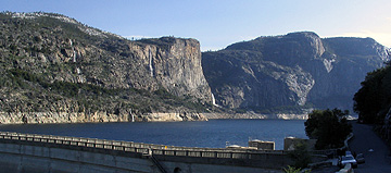
- 2005年04月11日 Hetch-Hetchy
- 2005年03月30日 Tioga Roadの除雪
- 2005年03月21日 John Muirの知名度
- 2005年03月12日 Fresh Look At Yosemite
- 2005年03月06日 積雪量
- 2005年01月30日 加州25セント硬貨いよいよ
- 2005年01月13日 2004年はビジター減少
- 2005年01月09日 Tuolumne Meadowsでの積雪
- 2005年01月06日 Badger Passの積雪状況
- 2005年01月01日 新年おめでとうございます
2005年12月29日
「ヨセミテ渓谷、ヨセミテ国立公園に編入」 100周年目
来年6月は、ヨセミテ渓谷とマリポサグローブが州立公園から、国立公園に編入することが決定してから100年目となります。以下は、ルーズベルト大統領がサインした法案の見出しです。
U.S. Statutes at Large, Vol. 34, Part 1, Resolution No. 27, pp. 831-32. "Joint Resolution Accepting the recession by the State of California of the Yosemite Valley Grant and the Mariposa Big Tree Grove, and including the same, together with fractional sections five and six, township five south, range twenty-two east, Mount Diablo meridian, California, within the metes and bounds of the Yosemite National Park, and changing the boundaries thereof."
H.J.R. 118; Public Resolution No. 27
全文は議会図書館のサーチで「H.R. 118 yosemite」と入力、最初のアイテムをクリック。さらに”View this item”をクリック。”township five south, range twenty-two east, Mount Diablo meridian, California,…”と言うのは、Public Land Survey Systemと言う1700年代から使われていた測量地図系での座標です。
2005年12月23日
Conditions Updateより
NPSのConditions Updateによれば、グレイシャーポイントロードはすでに冬期閉鎖になっているが、現在徒歩で上がる4マイルトレイルはまだ開いているようです。次の雪嵐まではだいじょうぶだろうとのこと。写真は12/20グレーシャーポイントから。
ヴァレーフロアには雪は見られませんね。
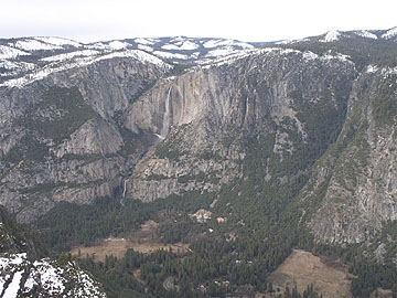
NPS
Yosemite Falls and Yosemite Valley from Glacier Point, 12/20. The Glacier Point Road is closed, however the Four Mile Trail remains open (though it will probably close with the next snowstorm).
2005年12月21日
Yosemite Association Holiday Sale
ビジターセンターに併設されているYAのブックストア12月20日から元旦までセールを行います。(最高50%
OFF)またヨセミテ・ミュージアムの併設ショップでは15%OFF(会員は20%OFF)になります。
年末に行かれる方は要チェックですね。
The YA Bookstore in the visitor’s center will feature selected books for sale up to 50% off from 12/20/05 until 1/1/06.
The YA Museum Store will feature a 15% discount for all merchandise, and YA members will receive a 20% discount from 12/20/05 until 1/1/06. The museum store is closed on Tuesdays and Wednesdays until the end of 2005, and will be open weekends only beginning January 2006. (M. Hansen - 12/20/05)
2005年12月10日
Yosemite in Time
PBSラジオ(KQED)によると、Mark Klettによるヨセミテの写真展が、UC Berkeleyで(まだ)開かれているとのことです。 Amazonでは写真集が安売りされています($29.70)。”Yosemite in Time”で検索してください。
2005年12月02日
Winter Closure
Conditions Updateのページの道路情報で、
Tioga Pass Road, Glacier Point Road ともに
ステータスが"call"から"closed"になりました。
今度こそ完全な冬季閉鎖になったということですかね。
http://www.nps.gov/yose/now/conditions.htm
2005年11月29日
マリポサグローブのギフトストア営業終了
マリポサグローブのギフトストアが今シーズンの営業を終了しました。
The Mariposa Grove Gift Shop will be closed for the season, after business on Sunday November 27, 2005. (M. Brindeiro - 11/28/05)
2005年11月28日
High Sierra 嵐の後
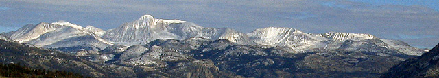
写真:North Peak, Mt. Conness, White Mountain, Pk. 12,002
「まだまだいけます…」と書いた後、すぐ嵐が来てしまいました。
それほど雪は降らなかったようですが、Tioga Roadはクローズ。
気温はかなり下がっています。また、明日から嵐が来そうです。
今度こそ春まで閉鎖でしょうか。
Hetch-Hetchy Day Use Parking Pass
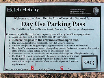
いつから始まったのか不明ですが、ゲートで写真のような許可証が渡されました。
車のダッシュボード上に掲示するように指示がありました。車のナンバーが控えられるのは
いつもと同じです。LE曰く「National Security…」とのことでした。
2005年11月23日
2005年11月21日
まだまだいけますHigh Sierra
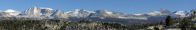
期待(?)を裏切り、Tioga Roadはいまだオープン。山(10,000ft.以下)にはほとんど雪がありません。火事の煙も消え、人も少なく、トレイルの砂埃も無くなり、絶好のハイキングシーズンかも知れません。
左からNorth Peak,Conness、White Mountain、Peak 12,002、Tioga Pass(周辺)、Dana、そしてGibbs。
2005年11月16日
Mariposa Grove
マリポサグローブのトラムツアー、ワワナ〜マリポサグローブのシャトルバスのサービスが今シーズンの営業を終了しました。マリポサグローブのギフトショップはまだ営業しているようです。
そしてマリポサグローブへの道路は最初の大きな降雪までは開いているということです。
The Mariposa Grove tram tours and the free Wawona shuttle bus service have ended for the season. The gift shop at the Mariposa Grove is open until further notice. The Mariposa Grove Road will remain open until the first major snow storm. (M. Brindeiro - 11/14/05)
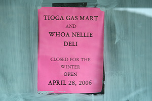
2005年11月12日
Tioga Gas Mart
Lee ViningのTioga Gas Martは今年もすでに冬期閉鎖で再オープンはApr-28-2006とのことでした。(張り紙されてます)
シェフはもうすでにバハマでしょうか。
給油は出来ます。
2005年11月01日
キャンプ場営業終了
North Pines と Lower Pines のキャンプ場の営業が先週末で終了しました。
あとは通年営業するUpper Pines,Camp 4, Wawona, Hodgdon Meadowの4つだけとなります。
---
Pines Campground will close for the season on 10/30/05. Upper Pines Campground, Camp 4, Wawona Campground, and Hodgdon Meadow Campground remain open year round. (M. Carter - 10/31/05)
2005年10月29日
2005年10月28日
Tioga Road再閉鎖
Glacier Pointでは雪が降っています。Tioga Rd.(Glacier Pt. Rd.も?)は来年まで閉鎖の可能性がかなり高いと思われます。
SR 120
[CENTRAL CALIFORNIA & SIERRA NEVADA]
IS CLOSED FROM CRANE FLAT TO 5 MI WEST OF THE JCT OF US 395 /TIOGA PASS/
(TUOLUMNE, MONO CO's) - DUE TO SNOW - MOTORISTS ARE ADVISED TO USE AN ALTERNATE
ROUTE
2005年10月27日
落石@Curry
25日午後、20トンの落石がCurry Village近くでありました。一時避難があったようです。
October 26, 2005
For Immediate Release
Rockslide in Yosemite National Park
No injuries or damages reported in approximately 20 ton rockfall
A rockfall occurred in Yosemite National Park at approximately 3:45pm on October 25, 2005 near Curry Village in eastern Yosemite Valley. No damage or injuries were reported from falling rocks.
Park officials estimate the rock release to be approximately 20 tons, which fell from about 800 feet above the floor of Yosemite Valley.
The majority of the rock fell into the existing talus slope behind the construction site for the new Curry Village Employee Dormitories. The construction site was designed to allow for rockfall while maintaining the safety of visitors and staff. The "fly rock," or falling debris from the initial release, fell primarily into a parking area under construction.
Approximately 200 park visitors were moved to alternative accommodations in Yosemite Valley or El Portal. Facilities were reopened today after an assessment was conducted by a park geologist this morning.
-NPS-
2005年10月25日
Tioga Road : 一時閉鎖 =>開通
SR 120
[CENTRAL CALIFORNIA & SIERRA NEVADA]
IS CLOSED FROM CRANE FLAT TO 5 MI WEST OF THE JCT OF US 395 /TIOGA PASS/
(TUOLUMNE, MONO CO's) - DUE TO SNOW - MOTORISTS ARE ADVISED TO USE AN ALTERNATE
ROUTE
Web Cam では、Cathedral・Merced山群方面は白いです。
ーーーーーーーーーーーーーーーーーーーーーーーーーーー
再開しました。が、今週末は嵐が来そうです。
This highway information is the latest reported as of Tuesday, October 25, 2005 at 11:14 .
SR 120
[CENTRAL CALIFORNIA & SIERRA NEVADA]
1-WAY CONTROLLED TRAFFIC AT VARIOUS LOCATIONS FROM VASCONCELLOS AVE
/IN MANTECA/ TO IRWIN ST /IN ESCALON/ (SAN JOAQUIN CO) FROM 1900 HRS EACH NIGHT
TO 0500 HRS EACH MORNING SUNDAY THRU FRIDAY THRU 11/18/05 - DUE TO CONSTRUCTION
[EASTERN SIERRA NEVADA]
NO TRAFFIC RESTRICTIONS ARE REPORTED FOR THIS AREA.
2005年10月22日
ヨセミテヴァレーの火入れ
昨日、ヨセミテヴァレーの東端部分の13エーカーで火入れが行われたようです。
この火入れはNPSのファイヤマネージャーおよび先住民部族が協力して行っており、生態系および共同体の保護をもたらします。
湿原地を回復させ、そして蔓延りつつある外来種である「ヒマラヤンブラックベリー」を焼くことが目的です。
Yosemite Valley Prescribed Fire Notification - October 21st, 2005
The National Park Service announces plans to conduct a prescribed fire in the east end of Yosemite Valley, weather and air quality conditions permitting, on Friday, October 21st.
This unit is 13 acres and the project should be completed in one day.
This project is significant for many reasons. Yosemite fire managers and the Southern Sierra Miwuk Nation are completing this project together for mutual benefit. It will provide important community protection as well as the many ecological benefits of fire on the landscape.
A specific goal of this project is to restore the wetland in the area by clearing conifers (ponderosa pine and incense-cedar) that have encroached and therefore lowered the water table. This creates a drier environment that continues to benefit conifers.
A second goal is the removal of the non-native Himalayan blackberry through timed burning. The Himalayan blackberry is very invasive and is choking out native, ethnographic resources that typically grow in this unit. For this reason, the prescribed fire is designed to achieve both ecological and cultural goals.
Monitoring plots are in the unit to determine the effectiveness of the fire on the unit as well as other methods that are being used in this restoration project. For example, plots will help determine if prescribed fire followed by removing Himalayan blackberry at the root system is more effective than fire alone.
The indigenous people of Yosemite Valley have used fire as a tool for thousands of years. Anthropogenic fires clear meadows and open the canopy for sun-loving species like the black oak --a staple food source for the indigenous people of Yosemite Valley.
Smoke impacts are possible-- particularly through the east end of the valley including the valley campgrounds, the Ahwahnee, and Curry Village. People should use caution when exerting themselves in smoky areas.
For further information:
・ Yosemite’s Fire Information Office: 209/372-0480.
・ Yosemite Fire Management Website: www.nps.gov/yose/fire (D. Schweizer - 10/20/05)
2005年10月19日
Porcupine Flatキャンプ場営業終了
Porcupine Flatキャンプ場が今シーズンの営業を終了しました。
---
Porcupine Flat Campground has closed for the season. (M. Carter - 10/18/05)
グレイシャーポイントのトイレ工事
グレイシャーポイントのトイレ工事が10/20から始まり、完成は28日の予定です。
---
Beginning October 20, 2005, new vault toilets will be installed at Glacier Point and will be completed by October 28, 2005.
----------
駐車場の数箇所に全部で6棟(12室)作られていました。
完成はしていますが、まだ使えないようで鍵がかけられていました。
現在は、もともとあるトイレが冬仕様(二室)で使われている(そしてそれだけ)ので、
長いトイレ待ち列ができてました。
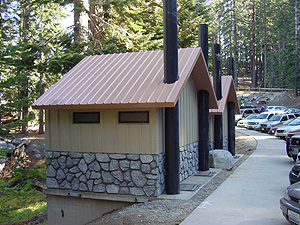
駐車場脇(バレー側)。
この他にも二棟建っていますが、扉側(谷の方)への通路がまだ
造られていません。
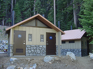
駐車場最奥のベアボックス前。
[10-31-2005 by suyama]
2005年10月18日
no overnight parking
10月15日以降、グレイシャーポイントロード、タイオガロードではオーバーナイト(夜間から朝にかけて)の駐車は禁止となっています。
--
Glacier Point Road (no overnight parking): Open
Tioga Road (Hwy 120 through the park) (no overnight parking): Open
2005年10月16日
Backpacker誌 2005年12月号
今月号(California Edition)の特集は、”The National Parks Issue”です。National Parkの将来(”The Future of National Parks”)、ヨセミテのDNCで働く人たち(”Yosemite@$7.38 An Hour”)、NPSの管理(”National Parks Inc.”)などに関する面白い記事が満載です。特に”The Future…”ではYosemite NPの公園長(Superintendent)のMike Tollefsonが登場しています。氏の好きな公園はNorth Cascadesだそうです。
Tollefson’ long career with the NPS includes the superintendency of Glacier Bay National Park in Alaska. He served as a ranger in Katmai, Denali and Lake Clark National Parks and Preserves in Alaska, and Virgin Islands (VI) and North Cascades (WA) National Parks. He also has been in policy leadership positions in the NPS regional office in the Pacific Northwest. He moved to Sequoia in 1995 where he focused on implementing the Giant Forest project, as well as acquiring the pristine Dillonwood property at the headwaters of the Tule River for Sequoia National Park (CA).
NPSより
2005年10月15日
ハーフドーム・今シーズン閉山
ハーフドームは頂上のステップが外され、来年の5月までシーズン閉山となりました。
今シーズンはトレイル工事があり平日の登山ができなかったこともあって、登頂された方は例年に比べてかなり少なかったようです。工事は終了しましたので、どうぞ来シーズンは奮ってチャレンジしてください。ハーフドームハイカーズクラブへのエントリーもお待ちしております。
Yosemite National Park News Release
October 17, 2005
For Immediate Release
Half Dome Cables Come Down for Season in Yosemite National Park
The cables on Half Dome in Yosemite National Park were taken down on Wednesday, October 12, 2005.
The cables extend approximately 300 yards up the steep shoulder to the 8,842-foot dome. They give access to the summit and to the unparalleled views of Yosemite Valley and the surrounding mountains of the Sierra Nevada.
The Sierra Club funded the installation of the first cables on Half Dome in 1919; the Civilian Conservation Corps replaced the original cables in 1934.
The cables will be re-installed at the beginning of the summer season in 2006.
-NPS-
2005年10月12日
キャンプ場営業終了
North PinesとCrane Flatのキャンプ場は先週末で営業終了、Hodgdon Meadowキャンプ場は当日受付になります。
---
North Pines Campground and Crane Flat Campground have closed for the season. Hodgdon Meadow is now first-come, first-served. (M. Carter - 10/11/05)
Tuolumne Groveの一時閉鎖
10月12,13日の両日、Tuolumne Groveはファイアマネジメント(火入れ)のため一時的に閉鎖になります。
---
The Tuolumne Grove of Giant Sequoias will be closed on October 12 and 13 due to a prescribed fire.
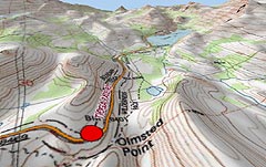
2005年10月09日
オルムステッド・ポイントのプロジェクト
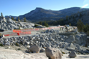
タイオガロード(120号線)からハーフドーム、クラウズレストを眺望するオルムステッド・ポイントで進行中の工事について、サンフランシスコ・クロニコル紙が報じています。眺めのいい場所までの短いトレイルが整備されるようで、関係者はこれを「インスタント・ウィルダネス」だと呼んでいます。
工事はタイオガロード冬期閉鎖をまたいで、来年の夏シーズン前に終了予定です。
2005年10月05日
メイレイクのトイレ
メイレイクのトイレが10/3で冬期閉鎖となりました。
----
May Lake Campground toilets closed for the season October 3, 2005. (M. Christiansen - 10/04/05)
2005年10月02日
煙のシーズン
少し古い(Sep. 26)ニュースですが、2,300エーカーほどのPrescribed Burn が予定されています。特に10月、Gin Flat(Crane Flatの東)付近はかなり煙そうです。
http://www.nps.gov/yose/news/2005/fire0926.htm より
Yosemite National Park Prepares for the Fall Prescribed Burn Season
Yosemite National Park fire managers plan approximately 2,300 acres of prescribed burning in the low to mid-elevation, mixed-conifer forest of the park in the upcoming fall months. These projects will be dependent on various conditions, including weather, air quality, fuel moisture levels, and available fire management resources.
Prescribed fire is an important tool used to reduce heavy undergrowth and built up forest debris while simultaneously opening the conifer forest structure and maintaining the health of the meadow habitats.
In Yosemite West (PW 17), two burn units, totaling 235 acres are planned for the end of September. This burn will assist in thinning nearby forest areas to help reduce unnatural levels of woody debris in areas that are in close proximity to public and private structures.
In the Mariposa Grove of Giant Sequoias, 66 acres are planned for ignition to help propagate the growth of giant sequoias and promote ecosystem health as well as prepare the open, sunny seedbed needed for them to germinate.
In Yosemite Valley, one small burn unit totaling 19 acres is planned in the east end of the valley, near Backpackers Campground. These projects aim to support ongoing oak woodland and meadow restoration goals.
In October, Yosemite fire managers plan to ignite 2,000 acres as a continuation of the Gin Flat Prescribed Burn (PW 3). 360 acres of this unit were burned in early September. This burn will be located near the Tuolumne Grove extending east to the burn boundary from the initial Gin Flat Prescribed Burn project in 2002. This burn will provide a reduction of both fuels and fire hazards to the Yosemite Institute, Crane Flat, and the Tuolumne Grove of Giant Sequoias.
To help minimize smoke impacts, this larger unit will be burned in smaller segments. The size and longevity of this project requires the close cooperation of park fire staff and county air quality managers. Daily collaboration will determine how many, if any, acres can be ignited from day-to-day, depending on how well smoke can be ventilated away from populated areas. Yosemite will manage the Gin Flat project following protocols regarding notifications for smoke levels.
In addition to prescribed burn projects, pile burning will be ongoing throughout the fall and winter months, dependent upon precipitation and available wet conditions. Be prepared to encounter smoke on the Wawona Road, south of Chinquapin as well as some areas along the Big Oak Flat road, west of Crane Flat.
Two trail closures are in effect due to the lightning-ignited Wapama Fire, which was ignited on September 20, 2005 and is being managed by fire crews. Trails closed are:
The Beehive Meadow trail above the Hetch Hetchy switchbacks
Frog Creek Trail
With all burn projects, smoke impacts to the roadway may occur, so please use caution when driving in and around the burn area where smoke, fire vehicles, equipment, and personnel may be present.
For more information on the park's burn plans and policies, call Yosemite's Prescribed Fire Office at 209/375-9574, 209/375-9577 (recorded information), or visit the park web site at www.nps.gov/yose/fire.
-NPS-
2005年09月28日
Tuolumne Meadowsキャンプ場営業終了
Tuolumne Meadowsキャンプ場が先週末で今シーズンの営業を終了しました。またWawonaのキャンプ場は当日先着順受付となっています。
いよいよハイカントリーはシーズンオフが近づいてきました。寂しいですね。
Tuolumne Meadows Campground has closed for the season.ハ Wawona Campground is now first-come first-served. (M. Carter - 9/26/05)
2005年09月27日
ハーフドーム・トレイル工事
NPSによるとハーフドーム・トレイル(サブドーム部分)の工事は予定より早く9/29の午後4時に完了します。その後10/10まで制限なしで通行可能です。そして10/11に頂上ワイヤーケーブルが外され(天候による)、オフシーズンとなる予定です。
Half Dome Cables - The work to repair the Sub Dome segment of the Half Dome Trail will be completed at 4 pm on Thursday, September 29, 2005. The Half Dome trail will be open without restriction through Monday October 10, 2005. On Tuesday October 11 the cables are scheduled to be taken down for the winter, weather permitting. (S. Baudoux - 9/23/05)
2005年09月20日
2005年09月18日
White Wolfキャンプ場営業終了
White Wolfキャンプ場が今シーズンの営業を18日で終了しました。
---
White Wolf Campground will close for the season on 9/18. (M. Carter - 9/16/05)
2005年09月16日
Climber Falls from Half Dome
Half Domeの垂直面を登っていたロッククライマーが転落死したそうです。
今回はロッククライマーでしたが、みなさんもくれぐれもお気をつけて。
(私はこの土曜日(17日)に登りに行く予定です)
Yosemite National Park News Release
September 15, 2005
For Immediate Release
Climber Falls from Half Dome
A rock climber fell to his death while rock climbing in Yosemite National Park yesterday, September 14, 2005.
Bela Feher, 35, of San Diego, California, was rock climbing near the "Slab Route" on the face of Half Dome, when he apparently fell 100 to 150 feet. Park Rangers were notified when his body was discovered by other rock climbers at 11:00 A.M. yesterday. Feher had technical rock climbing gear and apparently was attempting to climb the face of Half Dome. He was climbing alone.
The exact cause of death and other details are pending investigation.
2005年09月14日
シーズン営業終了 - Happy Isles Nature Center
Happy Isles Nature Centerが11日の日曜で今シーズンの営業期間を終えて閉館となりました。
近年このセンターはY.A.のボランティアスタッフに運営が任されており、この夏シーズンの運営の中心だった2名のボランティアの名前を挙げて感謝の意をあらわしています。
Happy Isles Nature Center Seasonal Closure - The Happy Isles Nature Center closed for the season on Sunday, September 11, 2005. Please join me in thanking MaryJane Johnson, Dawn Sherertz, and the rest of the talented and resourceful YA volunteer crews who kept the HINC open for visitors to enjoy for another summer. This rich interpretive facility would not be available to the public without the YA volunteers' efforts. You are the best! (L.? Rematore/Yosemite Association - 9/13/05)
2005年09月09日
4歳児の快挙
先日のレイバーデイウイークエンドにすやまさん一家がシエラ東方の山、White Mountain(14,250feet=4,343m)に登られました。4,343mですよ。
この山の登山道を管理している(ということでいいのかな)カリフォルニア州立大学の研究機関のページでなんと「 including 4 year old Tomo Suyama who walked all the way! 」として紹介されています。写真入りです。
まあ、先日のJohnson Peakでも「4歳児の快挙」だっったのですが。
“OPEN GATE DAY” was hosted on Sunday, September 4, between 7 am and 6 pm. Hikers wishing to climb White Mountain Peak were allowed to drive to the Barcroft Station to begin their ascent. Over 100 people participated, including 4 year old Tomo Suyama who walked all the way! (see center of photo) Our Annual Open House was hosted at Barcroft Sunday August 7, 2005. Details on web page, including photos of hailstorm.
2005年09月07日
営業終了
レイバーデイウィークエンドが終わり、Tamarack Flat、Bridalveil Creek、Yosemite Creekのキャンプ場は9月5日をもって今シーズンの営業を終了しました。
---
Campground closures: Tamarack Flat Campground, Bridalveil Creek Campground, and Yosemite Creek Campground will close for the season on Monday September 5th. (M. Carter - 9/06/05)
2005年09月06日
Red bear
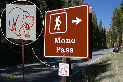
土曜日(9/3)にTioga Pass Rdを車で走っていたら、
所々で赤いクマの絵のマークのサインを目にしました。
先週は見た記憶がありません。
これは何だろう?と思っていたら、
Tioga Passのエントランスステーションに説明が張り紙されていました。
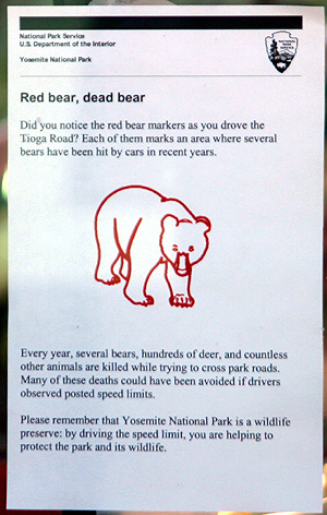
少なくとも以下の場所にはありました。
もっとあったような気がしていたのですが発見できませんでした。
T1 Tuolumne Grove
T4 view point
T10 Yosemite Creek Camp分岐
T15 Yosemite Creek
T17 Porcupine Flat
T35 Dana Meadow
T37 Mono Pass
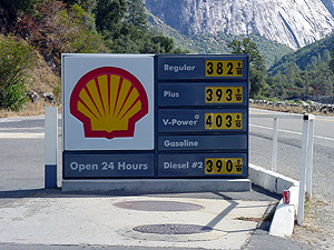
GAS price
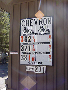
9/5のTuolumne Meadows GSのGas Price
他にも同じように写真を撮っている人がいて、
立ち話に花が咲いてしまいました。
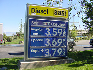
こちらはTioga Gas Mart
先週のハリケーン以降GAS価格が急騰してます。
2005年08月30日
Hetch Hetchy Entrance
9月6日以降、Hetch Hetchyへの出入りは午前8時〜午後7時となります。
----
Effective September 6, 2005 the Hetch Hetchy Entrance Station Hours will be changed to 0800 - 1900 hours. (C. M. Rawlings - 8/23/05)
2005年08月28日
Johnson Peak登頂!
朝のTuolumne Meadowsは3〜4度ぐらいまで冷えていました。天気は雲ひとつない快晴。
参加者全員が、無事3,300メートルの頂に立つことができました。皆さんお疲れさまでした。
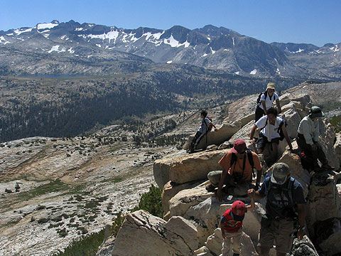
頂上にて。後方左側、雪のついた山は、ヨセミテの最高峰Mt. Lyell。
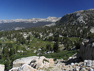
8時45分にキャンプ場を出発、1時間弱でElizabeth Lakeそばの分岐点(2.3マイル)に到着。其処からトレイルを外れ、道のない樹林帯を登って行くと小さなメドウ(写真)が出現。遠くに見える山はMt. Conness。
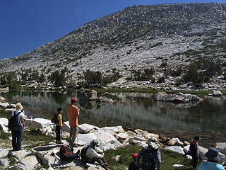
頂上(後方)アタック前に、湖の横で休憩。
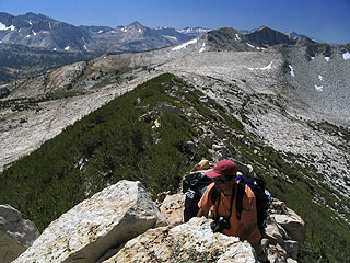
頂上に続く尾根。
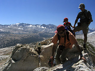
頂上は少しやせています。
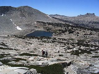
Johnson Peakの南西600メートル程のところにある無名の湖。遥かかなたにはMatthes CrestやEcho Peakが見えています。
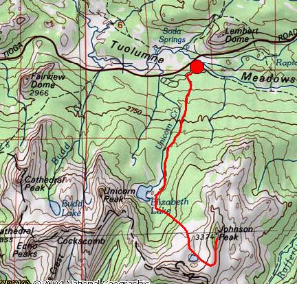
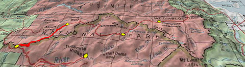
2005年08月27日
今日はTuolumneでHiking
今日は(8時半に)Tuolumne Meadowsのキャンプ場に集合し、裏山のJohnson Peakに登ってきます。参加者は、西村さん一行、投稿者の小林さん、すやまさん(family)、そして私たちです。Johnson Peakはキャンプ場のすぐ南にあります(地図)。Elizabeth Lakeまで約2マイル、其処からクロスカントリーで頂上を目指します。報告は16時間後にいたします。
2005年08月25日
Water-Related Accidents
今度はNevada FallとUpper Yosemite Fallだそうです。
過去の事故が教訓になっていないのでしょうかね。
Yosemite National Park News Release
August 24, 2005
For Immediate Release
Two Fatalities Result From Water-Related Accidents in Yosemite National Park
Two visitors in Yosemite National Park have died in the last week due to water-related accidents.
Rachael Neil, 22, of Mesa. Arizona was hiking with friends on the John Muir Trail above Nevada Fall. Neil slipped while jumping from rock to rock about 1/4 mile above the waterfall and was pulled down stream and underwater by the swift current. Despite attempts by search and rescue personnel, deep holes and high water conditions in the Merced River have prevented her body from being recovered. Recovery attempts will resume when water levels in the Merced River recede.
Shane Kinsella, 21, from Dublin, Ireland, fell over the top of Upper Yosemite Fall on Monday afternoon, August 23, 2005. He was posing for a photograph near the lip of the waterfall when he slipped, was unable to recover, and fell over the 1430 foot waterfall. Kinsella's body was recovered by Yosemite National Park rangers and rescue personnel in a pool at the bottom of Upper Yosemite Fall on Tuesday morning.
This is the fifth accidental death in Yosemite National Park this year.
-NPS-
2005年08月04日
Falling Over Vernal Fall
ハイカーがVernal Fallの上から滝壺まで落ちたそうです。
新聞記事にもなっていますが、まだ発見はされていないようです。
でもあの高さから落ちて無事ということはあり得ないでしょうね。
Yosemite National Park News Release
August 1, 2005
For Immediate Release
24-Year-Old Hiker Dies After Falling Over Vernal Fall
A 24-year-old hiker died Saturday in Yosemite National Park after falling over Vernal Fall. Chintan Chokshi, a San Francisco area resident, crossed the safety barrier at the top of the Fall to cool off after hiking, lost his footing, and was witnessed being swept over the fall. Rangers were called to the scene at approximately 11:15 am. Searchers will continue to look for Chokshi's body on foot and by helicopter through today.
Chokshi was hiking with friends on the popular Mist Trail in Yosemite National Park.
Signs at the bridge near Vernal Fall use strong language and international symbols to warn hikers of the dangers of entering the water in that area. High water levels, wet rocks, and strong currents make the area extremely dangerous. Swimming is not permitted in Emerald Pool or in river areas along the Mist Trail.
-NPS-
2005年08月03日
山火事情報
8/1のNPSからの発表によると、7月の落雷によって、現在、ヨセミテ国立公園内および周辺で2ヶ所の山火事が起こっているようです。
山火事は夏のシエラ山脈では通常の出来事で、林床に光が入り世代更新を助ける自然のプロセスのひとつです。消防隊によって監視が続けられています。
Yosemite Fire Information Update # 4 - August 1, 2005
A series of thunderstorms have passed through Yosemite National Park’s highcountry in the last two weeks. More are forecasted this week. Lightning-ignited fires from these storms will continue to spread naturally as long as they may be safely managed by park fire managers. Managed wildland fire use fires are routinely monitored to ensure that program’s goals are met.
Fire is a natural ecological process in Yosemite National Park. Each year, lightning strikes result in wildland fires that help shape Yosemite’s wilderness.? Naturally occurring fire allows forests to be thinned, opening the canopy and allowing sunlight through which allows for the sprouting and re-growth of plants, shrubs, and trees. Fire also allows for the recycling of nutrients to the soil while reducing the amount of dead, woody debris.
A second lightning fire, the Crystal Fire, was detected near the Echo Fire. The two fires will be managed together as the Echo Complex. These fires were most likely ignited sometime during a lightning storm that passed through the high-elevations of Yosemite during the week of July 18th. The decision has been made to manage these natural fires as a wildland fire use fire, allowing it to continue for additional resource benefit. All park trails and facilities are open.
?Below is a list of fires, including their size and location.
* Indicates the date the fire was detected.
The Echo Complex (Mariposa County): These fires show moderate potential for growth. They are burning in lodgepole pine and red fir. This area has been impacted by the lodgepole needle miner and fire activity will likely increase if it reaches areas with lodgepole mortality. There are four fire monitors tracking behavior and growth. Observed fire behavior includes creeping and smoldering with open flame with some torching in heavy fuels.?
The Echo Fire (*7/25): Fire size is currently 65 acres, and is located to the north of Echo Valley in the wilderness area of Yosemite. It is at roughly 8500 feet elevation.
The Crystal Fire (*7/28): Fire size is 2.5 acre and is at approximately 8900 feet elevation. It is surrounded by granite to the south and east.? There has been very little fire activity recently.
Additional Information:? The park website, www.nps.gov/yose/fire has information about fire activity and smoke effects in Yosemite.? (D. Schweizer - 8/01/05)
2005年07月19日
蚊!
YAのNews Roomに地元紙「Fresno Bee」の今シーズンのヨセミテの蚊についての記事が掲載されています。
DEETの話、西ナイル熱の話、ロッククライミングで友人のロープを掴んで支えていたら、腕が蚊に覆われたという話など、、、。
This year, Yosemite's heavier-than-normal snowpack has sent powerful waterfalls crashing over once-dry granite, filled rivers, and closed the park for one day because of flooding.
On the minute end of the scale, it has hatched thousands of buzzing, biting mosquitoes that love puddles of standing water.
Are there more mosquitoes than normal? Lots of Yosemite old-timers think so, and the bugs are present much later than in a typical year.
A recent article in the Fresno Bee polled a number of Yosemite visitors about their mosquito experiences.
2005年07月15日
ロッジポールパイン林の変色
NPSのDaily Reportが、Tuolumne Meadows周辺で、「 lodgepole needle miner(松葉の鉱夫)」と呼ばれる小さなガ(蛾)によってロッジポールパイン林の変色が進んでいると報じています。
みなさまもこれはと思うエリアがありましたら、ご報告ください。
Many have noticed discoloration of lodgepole pine forests in the greater Tuolumne Meadows area. This is due to a tiny moth called the lodgepole needle miner. The larvae live inside pine needles, eating them from the inside out, and only emerging in the late summer as small gray moths for a few weeks in the late summer of odd-numbered years. The lodgepole needle miner has few effective natural predators, as not many creatures can make a good living eating something that's only out a few weeks every other year. Repeated defoliation slowly starves trees, and makes them vulnerable to mountain pine beetle colonization. Needle miner populations generally keep rising until the overstory trees in an infested area die, then start building slowly again. Historically, large areas of lodgepole overstory die and leave isolated California red fir or mountain hemlock exposed to snow damage and wind throw. Approximately 50,000 acres of defoliation was mapped last year, and this is the fourth major episode since 1900. Many previously described "Ghost Forests" of lodgepole skeletons have since failed, and are the bane of many cross-country hikers. Small trees with foliage below the depth of the winter snow pack (ok, maybe not so small this season) are generally spared defoliation because melting snow wicks into the mined leaves by capillary action and drowns the larvae. This native, and nearly endemic forest insect is not likely to ever extirpate lodgepole from Yosemite, and may serve as a fire surrogate. Previous attempts to control lodgepole needle miners proved effective but several broad-spectrum chemicals would not be proposed with current knowledge of non-target effects. Lots more in the needle miner file, so contact Park Forester Brian Mattos for additional information. (B. Mattos - 7/14/05)
2005年07月02日
キャンプ場オープン(続)
Tuolumne Meadowsキャンプ場は一部サイトを7/8のオープン予定。White Wolf と Yosemite Creekは冬季にダメージを受けており、オープンはまだ未定のようです。
またTuolumne Meadowsのストア、グリル、ガソリンスタンドとマウンテンショップの営業が7/1から開始されます。
Yosemite National Park Opens Additional Facilities for Fourth of July Weekend
Yosemite National Park officials announced today that the Crane Flat Campground will be open on June 30, 2005, and Tamarack Flat Campground will open July 1, 2005. The anticipated opening date of the Tuolumne Meadows Campground is July 8, 2005, although sites may still be limited due to snow and standing water. There is no anticipated opening date for the White Wolf Campground or the Yosemite Creek Campground, both of which sustained some damages over the winter.
DNC Parks and Resorts, Inc. in Yosemite is anticipating that the opening date for the Tuolumne Meadows Grill, Tuolumne Store, Mountain Shop and Gas Station will be Friday, July 1, 2005.
2005年07月01日
キャンプ場オープン
Crane Flat、Tamarack Flatのキャンプ場がそれぞれオープンしています。その他のタイオガロード添いのキャンプ場のオープン日はまだ未定のようです。
Crane Flat Campground will open for the season on Thursday, June 30, 2005.? This is a reservation only campground.
Tamarack Flat Campground will open for the season on Friday, July 1, 2005.? This is a firs-come, first-serve campground.
The opening dates for the rest of the Tioga corridor campgrounds and Bridalveil Creek campground are still unknown at this time. (M. Carter - 6/30/05)
2005年06月23日
クレジットカード情報流出事件
米国のクレジットカード情報流出事件で日本でも不正使用の被害が拡大しつつあるようです。
アメリカでのお買い物、ホテル等のWEBサイトでの予約などでカード決済をされている方は要注意らしいです。
今朝のテレビでは使用明細を昨年8月にさかのぼって確認したほうがいいということでした。
2005年06月22日
High Sierra Camp 閉鎖
San Jose Mercury新聞によると、yosemiteの5つのHigh Seirra Camp(Glen Aulin, May Lake, Sunrise, Vogelsang, Merced Lake)は、雪の為営業はしないとの事です。これらは、くじ引きで選ばれた4,300人の幸運な人しか宿泊できない、キャビンです。勿論自前のテントを持って行って泊るのはOKです。
Tuolumne Meadowsの売店、ガススタンド、グリルは7月1日より営業開始予定のようです。またWhitewolf、Tuolumneのロッジは7月8日からのようです。
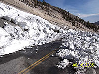
2005年06月18日
Tioga Road Update
On June 16, crews began to remove avalanche debris and snow from potential boulders from this rockslide near Olmsted Point.
過去ログ
4月15日
除雪開始
4月21日
Tioga Road April 21, 2005
Starting location: 4.3 miles East of Crane Flat
Ending Location: 4.8 miles East of Crane Flat
Distance plowed today: .5 miles
Snow depth: 11 feet
5月13日
Starting location: At White Wolf, 14 miles from Crane Flat Gate
Ending location: 14.5 miles from Gate
Distance plowed today: .5 miles
Snow depth is 15+ feet and getting deeper
Tioga Road progress for May 14, 2005
Starting location: 14.5 miles from Crane Flat Gate
Ending Location: 15.1 miles from Crane Flat Gate
Distance plowed: .6
Snow depth is 16 feet
May 16, 2005 10:57 PM
May 16th, all work on Tioga was suspended so crews could respond to the flood event in the Valley
May 17th.
Starting location: 15.1 miles from Crane Flat gate
Ending location: 15.6 miles from Crane Flat gate
Distance plowed today: .5 miles
Snow depth is 15 feet
Tioga Road progress May 21
Starting location: 20.6 miles from gate
Ending location: 22.2 miles from gate
Distance plowed: 1.6 miles
Snow depth: 6 feet
Tioga Road progress May 23
Starting location: 22.2 miles from gate
Ending location: 22.5 miles from gate
Distance plowed: .3 miles
Snow depth: 8 feet
Tioga Road progress May 24
Starting location: 22.5 miles from gate
Ending location: 25 miles from gate
Distance plowed today: 2.5 miles
Snow depth 4 feet
Tioga Road progress May 25
Starting location: 25 miles from Gate
Ending location: 25.8 miles from gate
Distance plowed today: .8 miles
Snow depth: 7 feet
Tioga Road report for May 26
Starting location: 25.8 miles from gate
Ending location: 26.6 miles from gate (May Lake Road)
Distance plowed today: .8 miles
Snow depth: 5 feet
No forward progress today (May 27). There was a substantial rock/mud slide in avalanche zone one. Slide was cleared by noon, however other emergency road repairs at several places throughout the park kept road crews busy the entire day.
Tioga Road report for May 31
Starting location: May lake turn-off
Ending location: Olmsted parking lot
Distance plowed today: 1.8 miles
snow depth: 4 feet
On June 1st, we will be preparing to cut through the Olmsted Avalanche zone. June 2nd, we intend to cut through the zone at Olmsted. Starting early, when there is a good freeze is imperative. Once we have cut through, the crews will go back west and let the snow takes its course. No work will be done for the rest of the day. An assessment will be done on Friday morning to see if it is safe for the crews to go through and proceed east.
Tioga Road report for June 2
Park crews were able to cut through the Olmsted avalanche zone today. After the cut, all personnel were sent back to work west of the zone while the avalanche team checks out the zone and waits the normal 24 hours to see if there will be any movement. If there is no activity, the crews will proceed eastward tomorrow.
Tioga Road report for June 4
Today, the crews were able to plow through avalanche zone 21 (Marmot Dome) and meet up with where the County left off. This does not mean that the road is opened. From Olmsted Point to Tuolumne Meadows, the road is plowed only a bit wider than one lane. Equipment failures have lead to this. We still need to widen these approximately 10 miles of road. We still have three active avalanche zones. In these areas, the road will remain only one lane wide until the zones are downgraded. The avalanche team believes Olmsted zone will probably remain a n avalanche zone for at least two more weeks. The road crews still need to plow out the administrative areas, widen the roadway, do ditching, road repairs, sweeping, and most of the signs along the road will need to be replaced. We still do not have a set opening date. We will be opening Segment 2, from Walker Party to Yosemite Creek, Thursday, June 9th.
Tioga Road report for June 14
Avalanche zones are still active on the Tioga Road. Park staff traveling on the road for administrative purposes are required to have avalanche training and equipment.
On June 14, crews began to remove boulders from this rockslide near Olmsted Point.
Tioga Road report for June 16
On June 16, crews began to remove avalanche debris and snow from potential boulders from this rockslide near Olmsted Point.
ハーフドームのワイヤー&ステップ設置
ハーフドームのワイヤー&ステップの今シーズンの設置作業がおわり、登山シーズンとなりました。
ただし今シーズンは頂上部分のトレイル補修が行われるので、7/4から10/4の月曜〜木曜:7時~
16時の間は通行止めとなりますのでご注意ください。
登山可能なのは金・土・日の終日です。月から木は16時以降、明朝7時までとなります。
The Half Dome cables are up for the season.
Please be aware that starting July 6th until October 4th, access to the summit of Half Dome will be limited due to closure of the Sub Dome segment of the Half Dome Trail for trail repair work. The work will require technical rigging (block and tackle) to move and place heavy stones on very steep terrain. The process is complicated and can be very hazardous to the trail crew employees and visitors without the closures. Please assist us on passing this information to other employees and park visitors.
Half Dome work schedule: July 6th to October 4th. CLOSED, Monday thru Thursday 7:00 AM to 4:00 PM.
OPEN (without restrictions) Friday, Saturday, Sunday, and in between the hours after 4:00 PM until 7:00 AM mid week. (J. Lopez - 6/17/05)
2005年06月15日
2005年06月10日
Tioga Road一部開通
The Tioga Road is open from Crane Flat to Yosemite Creek (no access to Tuolumne Meadows or US 395). No overnight parking permitted.
2005年06月03日
Tioga Road 一部開通間近
とりあえず、東と西からの除雪区間が片側一車線でつながったようです。
From Olmsted Point to Tuolumne Meadows, the road is plowed only a bit wider than one lane. Equipment failures have lead to this. We still need to widen these approximately 10 miles of road
ヨセミテクリークまでの一部開通が始まります。
We will be opening Segment 2, from Walker Party to Yosemite Creek, Thursday, June 9th.
詳しくはこちら
過去ログ
4月15日
除雪開始
4月21日
Tioga Road April 21, 2005
Starting location: 4.3 miles East of Crane Flat
Ending Location: 4.8 miles East of Crane Flat
Distance plowed today: .5 miles
Snow depth: 11 feet
5月13日
Starting location: At White Wolf, 14 miles from Crane Flat Gate
Ending location: 14.5 miles from Gate
Distance plowed today: .5 miles
Snow depth is 15+ feet and getting deeper
Tioga Road progress for May 14, 2005
Starting location: 14.5 miles from Crane Flat Gate
Ending Location: 15.1 miles from Crane Flat Gate
Distance plowed: .6
Snow depth is 16 feet
May 16, 2005 10:57 PM
May 16th, all work on Tioga was suspended so crews could respond to the flood event in the Valley
May 17th.
Starting location: 15.1 miles from Crane Flat gate
Ending location: 15.6 miles from Crane Flat gate
Distance plowed today: .5 miles
Snow depth is 15 feet
Tioga Road progress May 21
Starting location: 20.6 miles from gate
Ending location: 22.2 miles from gate
Distance plowed: 1.6 miles
Snow depth: 6 feet
Tioga Road progress May 23
Starting location: 22.2 miles from gate
Ending location: 22.5 miles from gate
Distance plowed: .3 miles
Snow depth: 8 feet
Tioga Road progress May 24
Starting location: 22.5 miles from gate
Ending location: 25 miles from gate
Distance plowed today: 2.5 miles
Snow depth 4 feet
Tioga Road progress May 25
Starting location: 25 miles from Gate
Ending location: 25.8 miles from gate
Distance plowed today: .8 miles
Snow depth: 7 feet
Tioga Road report for May 26
Starting location: 25.8 miles from gate
Ending location: 26.6 miles from gate (May Lake Road)
Distance plowed today: .8 miles
Snow depth: 5 feet
No forward progress today (May 27). There was a substantial rock/mud slide in avalanche zone one. Slide was cleared by noon, however other emergency road repairs at several places throughout the park kept road crews busy the entire day.
Tioga Road report for May 31
Starting location: May lake turn-off
Ending location: Olmsted parking lot
Distance plowed today: 1.8 miles
snow depth: 4 feet
On June 1st, we will be preparing to cut through the Olmsted Avalanche zone. June 2nd, we intend to cut through the zone at Olmsted. Starting early, when there is a good freeze is imperative. Once we have cut through, the crews will go back west and let the snow takes its course. No work will be done for the rest of the day. An assessment will be done on Friday morning to see if it is safe for the crews to go through and proceed east.
Tioga Road report for June 2
Park crews were able to cut through the Olmsted avalanche zone today. After the cut, all personnel were sent back to work west of the zone while the avalanche team checks out the zone and waits the normal 24 hours to see if there will be any movement. If there is no activity, the crews will proceed eastward tomorrow.
Tioga Road report for June 4
Today, the crews were able to plow through avalanche zone 21 (Marmot Dome) and meet up with where the County left off. This does not mean that the road is opened. From Olmsted Point to Tuolumne Meadows, the road is plowed only a bit wider than one lane. Equipment failures have lead to this. We still need to widen these approximately 10 miles of road. We still have three active avalanche zones. In these areas, the road will remain only one lane wide until the zones are downgraded. The avalanche team believes Olmsted zone will probably remain a n avalanche zone for at least two more weeks. The road crews still need to plow out the administrative areas, widen the roadway, do ditching, road repairs, sweeping, and most of the signs along the road will need to be replaced. We still do not have a set opening date. We will be opening Segment 2, from Walker Party to Yosemite Creek, Thursday, June 9th.
Tioga Road report for June 14
Avalanche zones are still active on the Tioga Road. Park staff traveling on the road for administrative purposes are required to have avalanche training and equipment.
2005年06月01日
除雪作業、Olmsted Pt.に達する!
やっとOlmsted Pointに達しました。
Tioga Road report for May 31
Starting location: May lake turn-off
Ending location: Olmsted parking lot
Distance plowed today: 1.8 miles
snow depth: 4 feet
Olmsted Pt.よりTenaya Lake方面: NPS Webの地図
El Portal マネジメントファイアー
今週、El Portalの裏山(Gas Standの裏付近)で64エーカーのマネージメントファイアーが予定されています。一日だけで終了の予定で、特に交通規制はしないようです。
El Portal Prescribed Burn Notification
May 31, 2005
The National Park Service announces plans to conduct an El Portal
Prescribed Burn this week in Yosemite National Park, weather and air
quality conditions permitting.
This burn is being conducted in mostly grass with scattered brush near the
Old El Portal community and is approximately 64 acres. The objective of
this burn is critical community protection in the grasslands surrounding
Old El Portal. Fire managers hope to create a break in the grasses that
can fuel a destructive fire under hot, dry conditions.
A series of prescribed burns near El Portal have provided fuel breaks that
help firefighters make a safer stand against wildfire. Some of these burns
helped firefighters with community protection during the Woodlot Fire two
years ago.
This burn should be a one day operation and residents should not expect
smoke to continue beyond that day.
Smoke impacts to the roadway may occur, so please use caution when driving
in and around the burn area where smoke, fire vehicles, equipment, and
personnel may be present.
For further information: Yosemite’s Fire Information Office:
2005年05月29日
ヴァレー厩舎オープン
ヴァレーのStables(厩舎)がオープンしています。乗馬ツアーのプログラムが始まります。
The Valley Stables will open for the season on Saturday, May 28, 2005 (K. Tucker - 5/27/05)
2005年05月27日
ハーフドーム
ハーフドームのワイヤーケーブルは6/16に張られると発表されました。
Half Dome Cables will be up by Thursday, June 16, 2005, weather permitting. (T. Ludington - 5/25/05)
2005年05月26日
Glacier Point Road 開通!
NPS web site
The Tioga Road is closed for the winter. It usually reopens in late May or early June, however a wet winter and spring will result in a later opening than usual.
All other park roads, including the Glacier Point Road, are open.
108号開通!
CalTransでは108号の規制がなくなっています。
SR 108
[CENTRAL CALIFORNIA & SIERRA NEVADA]
NO TRAFFIC RESTRICTIONS ARE REPORTED FOR THIS AREA.
[EASTERN SIERRA NEVADA]
NO TRAFFIC RESTRICTIONS ARE REPORTED FOR THIS AREA.
4、5日前は以下の状況でした。
SR 108
[CENTRAL CALIFORNIA & SIERRA NEVADA]
IS CLOSED FROM 26.4 MI EAST OF STRAWBERRY TO 5.3 MI WEST OF THE
JCT OF US 395 /SONORA PASS/ (TUOLUMNE,MONO CO's) - WINTER CLOSURE -
MOTORISTS ARE ADVISED TO USE AN ALTERNATE ROUTE - THE ESTIMATED DATE
OF REOPENING IS 5/27/05
26.4M地点はSonora Passへの上り口。
Tioga Road 除雪状況
ウエブサイトに地図が出ました。
メイレイクへの分岐地点近くまで来ています。次の目標はOlmsted Pointですね。
Tioga Road progress May 24
Starting location: 22.5 miles from gate
Ending location: 25 miles from gate
Distance plowed today: 2.5 miles
Snow depth 4 feet
過去ログ
4月15日
除雪開始
5月13日
Starting location: At White Wolf, 14 miles from Crane Flat Gate
Ending location: 14.5 miles from Gate
Distance plowed today: .5 miles
Snow depth is 15+ feet and getting deeper
Tioga Road progress for May 14, 2005
Starting location: 14.5 miles from Crane Flat Gate
Ending Location: 15.1 miles from Crane Flat Gate
Distance plowed: .6
Snow depth is 16 feet
May 16, 2005 10:57 PM
May 16th, all work on Tioga was suspended so crews could respond to the flood event in the Valley
May 17th.
Starting location: 15.1 miles from Crane Flat gate
Ending location: 15.6 miles from Crane Flat gate
Distance plowed today: .5 miles
Snow depth is 15 feet
Tioga Road progress May 21
Starting location: 20.6 miles from gate
Ending location: 22.2 miles from gate
Distance plowed: 1.6 miles
Snow depth: 6 feet
Tioga Road progress May 23
Starting location: 22.2 miles from gate
Ending location: 22.5 miles from gate
Distance plowed: .3 miles
Snow depth: 8 feet
Tioga Road progress May 24
Starting location: 22.5 miles from gate
Ending location: 25 miles from gate
Distance plowed today: 2.5 miles
Snow depth 4 feet
Tioga Road progress May 25
Starting location: 25 miles from Gate
Ending location: 25.8 miles from gate
Distance plowed today: .8 miles
Snow depth: 7 feet
Tioga Road report for May 26
Starting location: 25.8 miles from gate
Ending location: 26.6 miles from gate (May Lake Road)
Distance plowed today: .8 miles
Snow depth: 5 feet
No forward progress today (May 27). There was a substantial rock/mud slide in avalanche zone one. Slide was cleared by noon, however other emergency road repairs at several places throughout the park kept road crews busy the entire day.
Tioga Road report for May 31
Starting location: May lake turn-off
Ending location: Olmsted parking lot
Distance plowed today: 1.8 miles
snow depth: 4 feet
On June 1st, we will be preparing to cut through the Olmsted Avalanche zone. June 2nd, we intend to cut through the zone at Olmsted. Starting early, when there is a good freeze is imperative. Once we have cut through, the crews will go back west and let the snow takes its course. No work will be done for the rest of the day. An assessment will be done on Friday morning to see if it is safe for the crews to go through and proceed east.
2005年05月23日
108号(Sonora Pass)開通予定日発表
CalTransによると、5月27日に開通予定のようです。現在は上り口(26.4M地点)でクローズ。
SR 108
[CENTRAL CALIFORNIA & SIERRA NEVADA]
IS CLOSED FROM 26.4 MI EAST OF STRAWBERRY TO 5.3 MI WEST OF THE
JCT OF US 395 /SONORA PASS/ (TUOLUMNE,MONO CO's) - WINTER CLOSURE -
MOTORISTS ARE ADVISED TO USE AN ALTERNATE ROUTE - THE ESTIMATED DATE
OF REOPENING IS 5/27/05
2005年05月18日
規制解除
マーセド川の異常水位によるヴァレー内の通行規制は2005年5月17日午前6時30分頃(現地時間)に解除されました。
今回ヴァレーでの最高水位はおよそ11フィート6インチ(16日午後5時頃)だったようです。
・道路の破損は、いまのところ大丈夫なようです。
・ノースパインキャンプ場の一部サイト、ハウスキーピングキャンプの一部ユニットが破損しているようです。
毎度のことですが「洪水はヨセミテの自然のプロセスです」と書かれています。
みなさんもご理解ください。
May 17, 2005
Re-Opens Roads reopen in Yosemite Valley
Roads in Yosemite Valley were re-opened at approximately 6:30 AM on May 17, 2005. Initial assessments indicate that roadways were not damaged during yesterday's high water.
Campsites are currently being assessed for damage; those which have not sustained any damage should open by noon today. It is possible that some campsites in the North Pines Campground have sustained damage, and Yosemite National Park officials recommend that campers with reservations in North Pines call for information before coming to the park.
Additionally, some units in Housekeeping Camp have been damaged; those which have not will be open by noon today. Visitors with reservations in Housekeeping Camp should call Delaware North Company, Inc., at 559/252-4848 for information about their reservation. All other lodging and camping facilities in Yosemite Valley are open with no restrictions.
High water levels peaked at about 11 feet, 6 inches in Yosemite Valley at about 5:00 PM. Water was crossing both Southside Drive and Northside Drive in places from multiple sources including Bridalveil Creek, Ribbon Creek, and the Merced River.
Flooding is a natural process in Yosemite National Park. High snow levels this winter, combined with unsettled spring weather patterns, indicate that flooding may occur. Visitors are advised to check the web site www.nps.gov/yose , or call 209/372-0200 for current weather conditions
2005年05月17日
洪水警報!
雪解け水によりヨセミテ渓谷内はマーセド川の水位が異常に高くなっており、現在入場はできなくなっています。
状況と写真はこちら
http://www.nps.gov/yose/news/highwater/
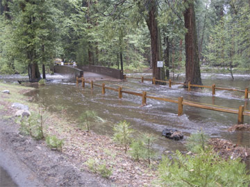
(Yosemite Creek Footbridge, May 16, 2005 NPS撮影)
May 16, 2005 (morning)
Yosemite Valley temporarily closed
High water is causing flooding in some Yosemite Valley areas, including campgrounds, parking areas, some lodging facilities, and picnic areas. Larger than usual snowpack, warm weekend weather, and rain have all contributed to higher than usual water levels.
Safety concerns, including road flooding and possible infrastructure damage, have prompted Yosemite National Park officials to close Yosemite Valley temporarily to traffic. In addition, all East Valley campgrounds are closed until further notice.
Other areas in Yosemite National Park, including Wawona and areas off of Highway 120 west including Big Oak Flat and the Merced and Tuolomne Groves of Giant Sequoias will remain open until further notice. Glacier Point Road and Highway 120 East (Tioga Road) are still closed.
Visitors are advised to check weather and road conditions before coming to Yosemite National Park. Information can be obtained at 209/372-0200 or on the park website at www.nps.gov/yose. Visitors with lodging reservations should contact Delaware North Company, Inc., at 559/ 252-4848 to check on current conditions.
2005年05月16日
White Wolf
6月に複数件WhiteWolfのテントキャビンを予約していたのですが、
DNCから電話があって、オープンしないのでキャンセルしてほしい
(あるいは日をずらしてバレーの部屋に代えてほしい)
との連絡がありました。聞いてみたところWhiteWolfのオープンは
今のところ7/1の予定だそうです。それまでにタイオガロードが全通しているか
どうかはわかりませんが、少なくとも7/1にWhiteWolfまでは行けるようです。
2005年05月15日
トレイル状況
NPSによるトレイル状況がアップされていました。
主な情報は
ヴァーナル/ネヴァダ滝トレイル ○
ハーフドーム頂上のワイヤー+ステップ作業はメモリアル・デー(5月最終月曜)を目標
4マイルトレイル 下部の2マイルまでオープン(未だ途中まで)
ミラーレイクループ 一部作業区間あり
ヨセミテ滝トレイル ○
それから公園内各地のトレイルで雪解け水で川の水位が上昇している(とくに今年は多い)ので、渡河するのが危険な箇所が多数あるようです。ご注意を。
Trail Conditions Update - The Vernal/Nevada Falls trail complex will be completely opened by Thursday morning for foot traffic. The trail will not be available for stock for perhaps another week or so until the trail is fully cleared of trees and the small snow banks that still exist in shaded areas. There is approximately 20-30% snow cover in Little Yosemite Valley. It is hoped the Half Dome cables will be up for Memorial Day, but that is weather dependent.
The lower 2 miles of the 4 Mile Trail are open. The trail on the south side of the Mirror Lake loop was damaged by a large fallen tree, but trail crews are currently working on it, and it should be repaired in a few weeks. It is passable on foot, but not with stock. The Yosemite Falls Trail is completely open for foot traffic, although some snow patches exist at the top. The Snow Creek switchbacks should be clear of snow to the top. The loop across to the Yosemite Falls Trail may be difficult to follow due to snowy sections, and is not recommended yet.
Hikers might consider trails out of the Hetchy area toward Beehive or Rancheria, or out of Wawona toward Chilnualna Falls. High water challenges have already been seen by hikers, including flooding on trails and difficult creek crossings. Hikers should be extremely careful regarding high water this year, as many creeks may be hazardous to cross well into the summer. Although any crossing can be dangerous, Tamarack and Cascade Creeks on the Old Big Oak Flat Road trail, Bluejay Creek upstream from Yosemite Falls, and the crossing above Chilnualna Falls camping area are "close-in" areas which are commonly very difficult in high water. (L. Boyers - 5/12/05)
2005年05月12日
Glacier Point Road除雪状況
二日前(10日)で、7.4マイルほどの除雪を終えています。あと25%を残すだけです。まだ正式発表はありませんが、月末のメモリアルウイークエンド開通を目指しているのでしょうか(かなり難しそうですが)。黄色点:左手前はTunnel View、右はBadger Passのスキー場(除雪開始点)。奥は左からCurry Village、Glacier Point、除雪到達地点。東は上側。
11日の状況がUPされています。8.4マイル地点です。除雪終了のあとすぐには開通しませんが、なんとなく5月末開通ができそうな気配です。
金曜日(13日)の状況です、SUYAMAさんのコメントのように駐車場まで達しました。まだ開通の予定日は出ていません。
Glacier Point:
We are now at the parking lot. Although we are at the Glacier Point parking lot, there is still a lot of work to be done before any traffic can be allowed to Glacier Point. We have to widen the road (cut back the snow banks), trim trees sticking out into the roadway, road repair, ditching, and all of the sign work. We also need to plow out all the turnouts and access roads.

Valleyの俯瞰:赤い点は、手前左からSentinel Dome、Glacier Point駐車場、Curry Village、Vernal Fall、 Nevada Fall。奥はYosemite Falls、 Mirror Lake、Half Dome(北は上側)。
2005年05月05日
Tioga Road 除雪状況
4月19日ごろに始まったTioga Roadの除雪は、昨日Crane Flatから12マイル地点まで達しました。White Wolfまでもうすぐです。去年は4月末に除雪は終わり、5月15日には開通でした。今年はかなり遅れそうです。Tioga Road上の黄色点は左からCrane Flat、 5/3の除雪到達点、Olmsted Point、Tuolumne Meadows。手前はYosemite Valley。
2005年05月01日
Access Yosemite
ヨセミテ滝トレイルの整備(車イスでもアクセスできる)、ビジターセンターの整備が終わり、これを紹介するSan Francisco Chronicle紙の記事が写真入りでY.A.のサイトに掲載されています。
2005年04月11日
Hetch-Hetchy
3日前の嵐で、標高4000ft.付近まで雪が降ったようです。北向き斜面には、かなり雪が残っていました。滝が三本できていました。ルピナスも今が盛りと咲いています。ダムの貯水量は半分程度です。
2005年03月30日
Tioga Roadの除雪
NPSによると、今年のTioga Roadの除雪(4/15に開始)には、かなり時間がかかりそうです。
There is no estimated opening date for 2005.
Plowing of the Tioga Road will begin on April 15th (and on April 18th for the Glacier Point Road). As of March 1, snowpack is significantly above average and, based on wind conditions this winter, it's expected that many trees will be down (but covered by snow), which could slow plowing operations.
2005年03月21日
John Muirの知名度
John Muirは実際のところ、アメリカで有名なのでしょうか?残念ながら知名度ランキングは見当たりません。そこでAmazonのセールスランキングをしらべてみました。
John Muir:
The Wild Muir: Twenty-Two of John Muir's Greatest Adventures #172,134
Meditations of John Muir: Nature's Temple #319,046
My First Summer in the Sierra #253,887
The Yosemite #285,395
John Muir: The Eight Wilderness Discovery Books #174,390
The Wilderness World of John Muir #60,446
かなり苦戦のようです。
ちなみにAnsel Adamsは以下のとおりです
The Camera (Ansel Adams Photography, Book 1) #14,738
The Negative (Ansel Adams Photography, Book 2) #7,398
Americas Wilderness: The Photographs of Ansel Adams #23,522
Examples : The Making of 40 Photographs #6,651
今年はLewisとClarkに率いられた探検隊が、初めてアメリカ大陸を横断して太平洋に到達してから200年目に当たります。彼らに関する本は
Undaunted Courage: Meriwether Lewis Thomas Jefferson and the Opening of the American West #5,732
National Geographic Guide to the Lewis & Clark Trail #29,117
Lewis And Clark On The Trail Of Discovery : An Interactive History with Removable Artifacts (Lewis & Clark Expedition) #14,013
で、#1は
Harry Potter and the Half-Blood Prince (Book 6)でした。
2005年03月12日
Fresh Look At Yosemite
10年越し(計画から終了まで)のヨセミテ滝周辺の工事が終わったそうです。
San Jose Mercury Newsの一面記事になっています。
記事では http://www.yosemitefund.org を参考にしています。
工事費用の主な募金者:
$1.7M 入園料、連邦の基金
$1M Sunset Magazinの(前)出版者Bill Lane
$1M Chevron Texaco(石油会社)
$1M Mary Bell Floyd Memorial Fund
$500K ヨセミテライセンスプレートからの収益
SJ Mercuryのon-line版は
Yosemite makeover
”In an effort to restore natural character, officials at Yosemite National Park have completed a $13.5 million renovation of the visitor areas around the base of Yosemite Falls.”
2005年03月06日
積雪量
現時点で平年より雪が多そうです。
5月末のTioga Road開通は微妙なところです。
The March 1st snow surveys showed that both the Merced River basin's snowpack is 146% of average and the Tuolumne River basin's snowpack is at 153% of average (water content) for this time of year
2005年01月30日
加州25セント硬貨いよいよ
ハーフドームとジョンミューアをデザインした25セント硬貨がいよいよ月曜日にお目見えのようです。
(NPSのDaily Reportより)
New Today
It's coming! It's coming!
The Times-Standard
On Monday, the U.S. Mint will release the California state quarter -- the first state quarter to be released this year.
The California state quarter will bear a likeness of John Muir, one of the world's most famous and influential conservationists. Muir convinced Congress in 1890 to establish Yosemite National Park and later inspired President Theodore Roosevelt to expand Yosemite and create additional national parks and forests.
The U.S. Mint began minting the state quarters in 1999 and has scheduled five quarters to be released each year -- running from the Delaware quarter on Jan. 4, 1999, until the Hawaii quarter on Aug. 21, 2008.
The California state quarter will be the 3st in the series to be issued. Other quarters being minted and released this year include Minnesota, Oregon, Kansas and West Virginia.
2005年01月13日
2004年はビジター減少
昨年(2004年)の一年間のヨセミテ入園者数はこの14年において最も少なく、340万人を下回ると、地元紙「Fresno Bee」が報じています。
http://www.yosemite.org/newsroom/clips2005/january/011005.htm
2005年01月09日
Tuolumne Meadowsでの積雪
ちょうど一年前、Tuolumne Meadowsでの積雪(Snow WC:雪が含む水の量に換算)は14.62インチでした。今日は14.38インチです。 今年の冬は雪が多いと思っていましたが、意外にも現時点では同じくらいです。 ちなみに去年の最大積雪(19.78インチ)は、3月3日に記録しました(後半はあまり雪が降りませんでした。ので、Tioga Roadは5月中旬に開通しました)。
2005年01月06日
Badger Passの積雪状況
去年のクリスマスごろから既に4フィートほど積もりました。
今年の冬はエルニーニョで積雪が多くなりそう、とのことです。
Tioga Passの開通日はいつごろでしょう?
Date: Wednesday, January 5, 2004
Time: 5:02am
Base Depth: 6-9 feet
New Snow Last 24 Hours: 6 inches and still falling.
Surface Conditions: Powder and Groomed Powder.
Weather Forecast: Partly cloudy. Highs 22 to 32.