Current Situation
Total Personnel 3,027
Size 253,332 acres
Percent Contained 80%
Estimated Containment Date Friday September 20th, 2013 approx. 12:00 AM
9月8日のデータを赤でプロット。
動員数は約3000とピークから2000にほど減っています。
「News」カテゴリーアーカイブ
RIM FIRE (CA120 reopen)
Highway 120 Opening Today at 12pm
Incident: Rim Fire Wildfire
Released: 11 hrs. ago
NEWS RELEASE
For Immediate Release
STATE ROUTE 120 FROM GROVELAND TO YOSEMITE NATIONAL PARK WILL REOPENRoad opens at Noon on Friday September 6
State Route 120 (SR-120) from Groveland CA into Yosemite National Park will reopen to all vehicular traffic at noon Friday September 6 2013.
Visitors will have full access to Yosemite Valley via SR-120. However due to continued fire activity in the area stopping along the roadway is strictly prohibited. The public is advised to use extreme caution as firefighting activities continue in this area.
Cherry Lake Road Evergreen Road Old Yosemite Road Harden Flat and all other secondary roads and trailheads off of SR-120 remain closed.
SR-120 (Tioga Road) remains closed from Crane Flat to White Wolf within Yosemite National Park. Park visitors can access the Tuolumne Meadows area from SR-395 via the parks east entrance at Tioga Pass.
For updated road conditions and information visit Caltrans’ website: www.dot.ca.gov/ or call Caltrans District 10 Public Affairs Office at (209) 948-7977.
This highway information is the latest reported as of Friday, September 6, 2013 at 18:58 .
SR 120
[IN THE CENTRAL CALIFORNIA AREA & SIERRA NEVADA]
NO TRAFFIC RESTRICTIONS ARE REPORTED FOR THIS AREA.
[YOSEMITE NAT’L PARK]
IS CLOSED FROM 8 MI EAST TO 26 MI EAST OF THE
WEST YOSEMITE NATIONAL PARK BOUNDARY (TUOLUMNE CO) – DUE TO A WILD FIRE
– MOTORISTS ARE ADVISED TO USE AN ALTERNATE ROUTE
FOR YOSEMITE NAT’L PARK ROAD INFORMATION CALL 209-372-0200
RIM FIRE
Current Situation
Total Personnel 3,634
Size 237,341 acres
Percent Contained 80%
Estimated Containment Date Friday September 20th, 2013 approx. 12:00 AM
9月5日のデータは水色。
火事の原因はハンターによる火の不始末のようです。National Forest内でマリワナなどを違法栽培するケースが多々ありますが、今回はそれとは関係ないとのことです。さらに調査の必要があり、ハンターの名前はまだ公表していません。
Forest Service Releases The Cause of The Rim Fire
Incident: Rim Fire Wildfire
Released: 10 hrs. ago
NEWS RELEASE
U.S. Forest Service
Pacific Southwest Region
Contacts: Stanton Florea, Pacific Southwest Region, Public Affairs (707) 562-9014
Ray Mooney, Pacific Southwest Region, Public Affairs (707) 562-8995
http://www.fs.usda.gov/r5
Investigators discover cause of Rim Fire
VALLEJO, Calif., Sept. 5, 2013 – Investigators from the U.S. Forest Service Law Enforcement & Investigations and Tuolumne County District Attorney’s Office have determined the Rim Fire began when a hunter allowed an illegal fire to escape. There is no indication the hunter was involved with illegal marijuana cultivation on public lands and no marijuana cultivation sites were located near the origin of the fire. No arrests have been made at this time and the hunter’s name is being withheld pending further investigation.
The Rim Fire began Saturday, Aug. 17, 2013, on the Stanislaus National Forest near the area known as Jawbone Ridge. The fire has burned 237,341 acres and is 80 percent contained.
Rim Fire
Basic Information
Incident Type Wildfire
Cause Under Investigation
Date of Origin Saturday August 17th, 2013 approx. 03:15 PM
Location Groveland Range District, Stanislaus NF
Incident Commander Wilkins/lawshe
Current Situation
Total Personnel 4,185
Size 235,841 acres
Percent Contained 80%
Estimated Containment Date Friday September 20th, 2013 approx. 12:00 AM
2013/Sept/2 のデータをマゼンタでプロット。各方面で避難勧告解除が出始まりました。
Webに訂正があり、9月20日が100%containmentのターゲットのようです。また、動員数も4,200と減っています。
Rim Fire (time lapse)
Crane Flat Helibase とGlacier Point から。
Washington Post
キャンプ終了/RIM FIRE
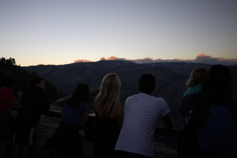
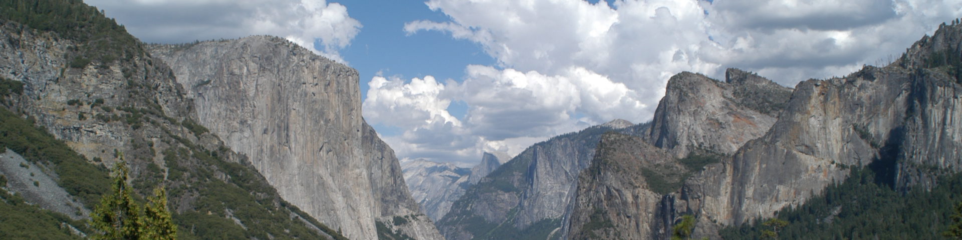
グレイシャー・ポイントから望む「RIM FIRE」(2013.8.29 19:39)
昨日無事、ベイエリア・サンフランシスコに戻ってきました。
RIM FIREの影響をもろにうけました。
8/28の正午でタイオガロード(クレーンフラット〜ホワイトウルフ)がクローズという通知があり、Tuolumune Meadowsでの日程を切り上げ、Wawonaのキャンプ場に引っ越しました。
途中、タイオガロードのすぐ近くまで火が迫っているのがみえました。(Fire Departmentが迎え火を打っていたのかもしれません)
Wawonaで2泊を過ごしましたが、29日のサンセットを見にグレイシャーポイントにあがったところ、大規模な煙が上がっていました。
これは雨がくるまでは消えないでしょうね。
ベイエリアに戻ってきたら、こんどはベイブリッジのクローズです。
今回は迂回だらけのキャンプとなりました。
Rim Fire(9/1)
Sierra Wildland Fire Reporting Systemで、Crane Flat のヘリーポートからの写真が見れます。
8月20日9時9分までは東南東(Gin Flat方面)を向いていますが、9時20分から北西に向けられ、煙が写っています。23日にはかなりの煙が上がっています。
Crane Flat Helibaseからの写真 [okをクリック、画面が出たら日付と時間をプルダウンメニューで指定]

動員数役5千人、Containment Dateが9月20日から10月20日になったようです。
Current Situation
Total Personnel 4,995
Size 219,277 acres
Percent Contained 35%
Estimated Containment Date Sunday October 20th, 2013 approx. 12:00 AM
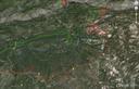
8月31日のデータをオーバレーイ。青が31日のライン。
郡境界ははずし、120、Tioga Rdを黄色でプロット。
Crane Flat Helibaseの位置を追加。 ヨセミテバレーにはついに煙が入り、視界が落ちています。
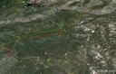
Rim Fire(8/31)
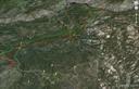
Greenは28日、赤は今日30日のデータ。
Merced、Tuolumne Glove、Crane Flat、Crane FlatからTioga Rdを4マイルほど上ったGin Flat。
マーカーT5、右側に滝の見えるところをプロット。
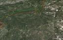
Rim Fire(8/30)
InciWebページの右端中ほどにIncident Perimetersの欄があり、火災の広がりの状況がGoogleEarthで読み込め、オーバーレイできます。
http://inciweb.nwcg.gov/incident/3660
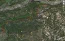
以下はBofエントランス、120号とHetch Hetchyへ向かうEvergreenの交差点、
EvergreenとOld Tioga Roadの交差点、Aspen Valley、White Wolfを28日のデータとともにプロットしたものです。fire lineはおおよそOld Tioga Roadに沿っています。
[Old Tioga Road(未舗装)は、EvergreenからAspen Valleyまでは許可のある車両のみ通行できますが、そこから東側White Wolfeまでは廃道化しており、沢にかかる橋も落ちています]。
下側、小さな写真のアイコンが多く見られるところが現在のTioga Rd.が走っているあたり。緑の線はTuolumneとMariposa郡の境界(TuolumneとMerced水系の分水界)。
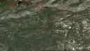
Rim Fire(8/29)
RIM FIRE INFORMATION
Update #19
Release for Wednesday, August 28, 2013/Time: 6:30 PM
Incident Statics
Acres Burned: 192,466 (301 square miles) Structures Threatened: 4,500
Containment: 30% Structures Destroyed: 111
Fire Start Date: August 17, 2013 Injuries: 4
Fire Cause: Under Investigation Total Personnel: 4,537
Cost to date: $39.2 Million
4500+まで増員されています。firelineは30%ほど(先週末は5%?7%)。
Bofエントランスのすぐそばまで火が迫っているようです。
Tuolumne水系の公園西側、ヨセミテクリーク西側、Mt. Hoffmann西側は閉鎖されています。
http://www.nps.gov/yose/planyourvisit/upload/rimfireclosure-082713.pdf
よく使われる”Contained/Containment”について
How Do You Rate a Forest Fire?
Chris Suellentrop
Posted Wednesday, Aug. 15, 2001, at 5:03 PM ET
Most of the news stories about the 43 large wildfires in the Western United States report some level of “containment” reached by firefighters. What does it mean to contain a fire, how is the percentage calculated, and when is a fire “controlled”?
To prevent a blaze from spreading, firefighters dig a “fire line” around its circumference. If three miles of fire line have been built around a fire that is 10 miles in circumference, then 30 percent of the fire is contained.(外周10マイルの火事に対して3マイルのトレンチなどのFirelineが作られると30%conainedされたという)
Fire lines are trenches dug to create a “fuel break” around the fire. Fires need fuel, oxygen, and heat to burn, and the easiest of the three to eliminate is fuel. Fire lines can also include “natural” barriers such as roads, rock bluffs, or streams.
Once a fire is fully contained, firefighters work on “controlling” it by battling it inside the containment line. A controlled fire is one that has no risk of expanding beyond the fire line.