ハーフドーム登山の事前許可制は今シーズンは平日にまで拡大されました。1日400名限定。
http://www.nps.gov/yose/planyourvisit/hdpermits.htm
「ハイキング」カテゴリーアーカイブ
Waterwheel Falls
BBSで盛り上がってしまいましたが、本当のWaterwheelは奥にありました。すでにFumiさんの写真で紹介されていますが、7月10日版でUPします。地図を入れた、滝・トレイル案内の記事は、明日にでも書こうと思います。
California Fallsそばの冠水地帯はかなり乾いてきました。うまく倒木などを使えば、サンダルなしでもOKです。
はだしで越えてきた女性も見かけました。Tuolumneの水量は、6月に比べかなり落ちてきています。
Waterwheel Falls
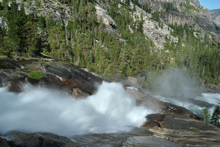
同上。反則技でNDフィルターを使用、シャッタースピードを遅くしてみました。
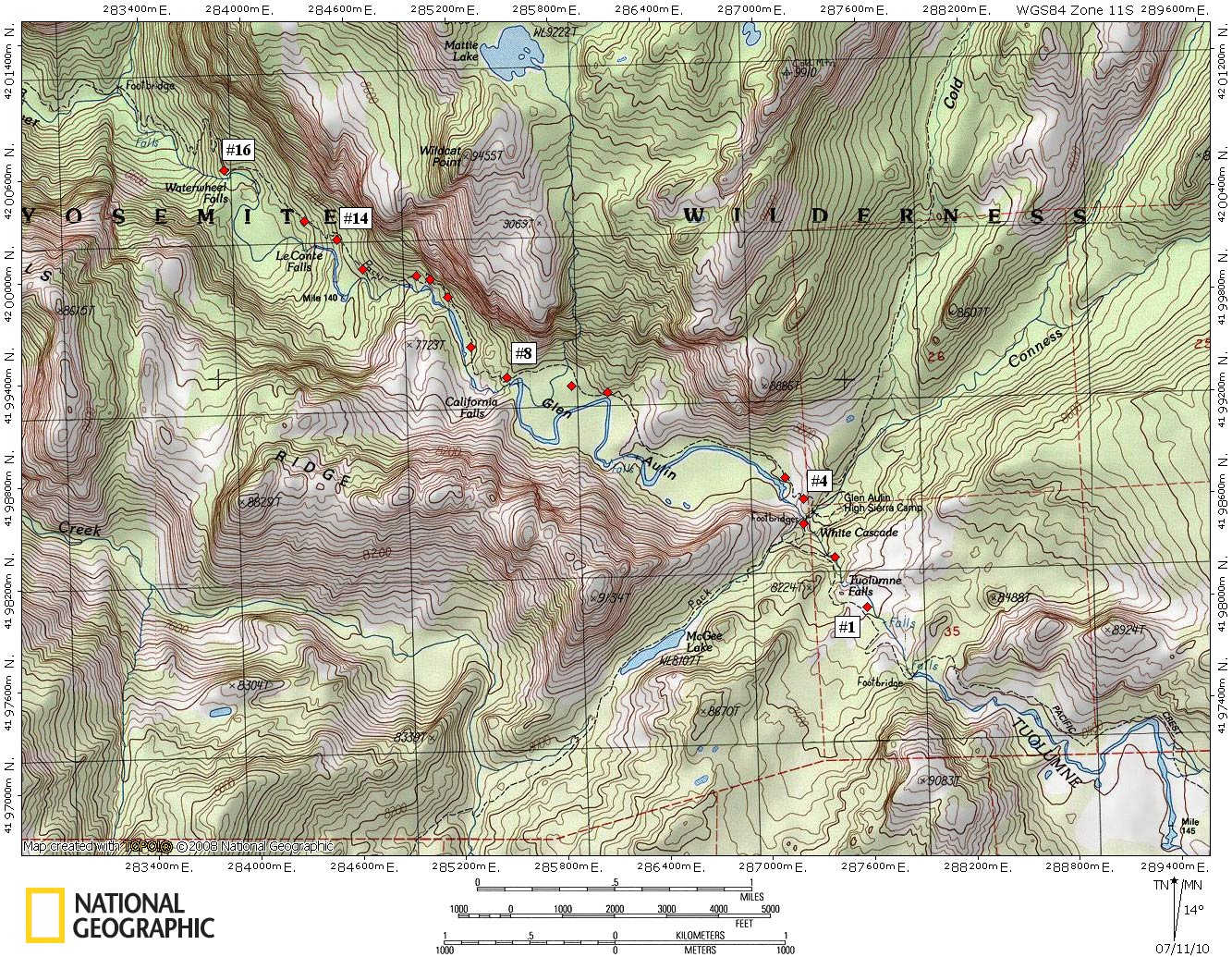
Tuolume五大瀑布ハイキングガイド。
[1] 無名の滝ですが、とても感じのいいところ。
[2] Tuolumne Falls。
[3] White Cascade。対岸にはGA HSCのキャビンが見えています。
[4] Glen Aulinの高台より北西を望む。右側奥の岩壁はWildcat。
[4] 同地点南東側にはWhite Cascade(下)とTuolumne Falls(上)が見えます。
[5] [4]の写真手前のプール。
[6] トロ状のゆっくりした流れ。南側の写真。釣り竿を持ったハイカーを結構見かけます。
[7] 西側を撮影。聳えているのはWildecatの岩壁。このすぐ先でトレイルは冠水し始めます。
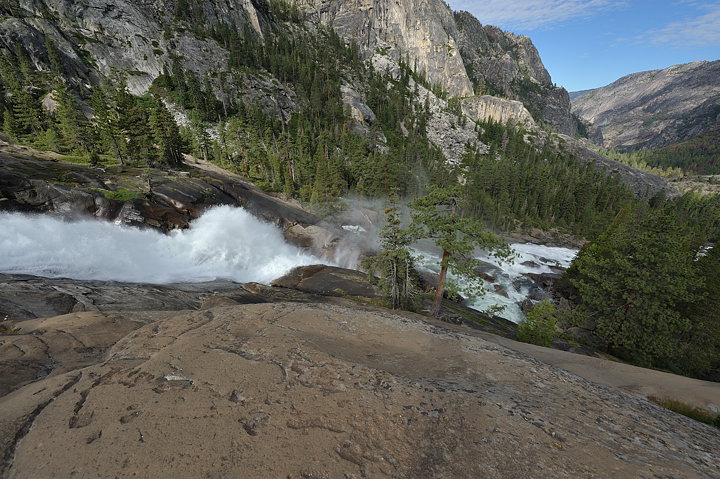
[8] 冠水地帯を抜けるとすぐ、California Fallsが現れます。
[9] 北東を望む。一番奥の岩壁下にLeConte滝があります。
[10] ゆっくりした流れはここから突然段々下りとなります。
[11] ここから先の段々部を、LeConteと勘違いしまいました。
[12] 一休みして、水と戯れるのにいい場所。
[13] 南南西には、Mile140地点のプールが見えています。そぐ横には、Tuolumneの流れの音を反響させる,不思議な岩があります。
[14] トレイルが下りはじめる直前で、流れの方に進むと、LeConte滝を一望できる展望台があります。タイミングが合えば、虹が見えます。
[14.1] そこからスイッチバックを下っていくと、トレイルはLeConte滝に段々近づいていきます。横道があるのでそこを進むと中段に出ます。下流方面。
[14.2] 滝の落ち口方面。水車がたくさん出ています。
[15] トレイルは次第に滝から離れて行きます。これはLeConte滝。
[16] Waterwheel Falls:滝の上部はかなり開けた平らな岩場。そばにはキャンプ地があります。
[16] Waterwheel Fallsと複数形であるものの、水車は大きな一個だけしかありません。ここもタイミングによって、大きな虹が出ます。
[16] 水車は左上。Tuolumneの全水流はここに流れ込んでいます。
![[1]](http://www.yoshino.com/MISC/20100710/701_2806.jpg)
![[2]](http://www.yoshino.com/MISC/20100710/701_2805.jpg)
![[3]](http://www.yoshino.com/MISC/20100710/701_2803.jpg)
![[4]](http://www.yoshino.com/MISC/20100710/701_2802.jpg)
![[4]](http://www.yoshino.com/MISC/20100710/DSC_1987.jpg)
![[5]](http://www.yoshino.com/MISC/20100710/701_2799.jpg)
![[6]](http://www.yoshino.com/MISC/20100710/701_2797.jpg)
![[7]](http://www.yoshino.com/MISC/20100710/701_2796.jpg)
![[8]](http://www.yoshino.com/MISC/20100710/701_2788.jpg)
![[9]](http://www.yoshino.com/MISC/20100710/701_2784.jpg)
![[10]](http://www.yoshino.com/MISC/20100710/701_2781.jpg)
![[11]](http://www.yoshino.com/MISC/20100710/701_2780.jpg)
![[12]](http://www.yoshino.com/MISC/20100710/701_2776.jpg)
![[13]](http://www.yoshino.com/MISC/20100710/701_2774.jpg)
![[14]](http://www.yoshino.com/MISC/20100710/701_2765.jpg)
![[14.1]](http://www.yoshino.com/MISC/20100710/701_2764.jpg)
![[14.2]](http://www.yoshino.com/MISC/20100710/701_2762.jpg)
![[15]](http://www.yoshino.com/MISC/20100710/701_2760.jpg)
![[16]](http://www.yoshino.com/MISC/20100710/701_2751.jpg)
![[16]](http://www.yoshino.com/MISC/20100710/701_2702.jpg)
![[16]](http://www.yoshino.com/MISC/20100710/701_2721.jpg)
ハーフドーム登頂開始
16日水曜日から、ハーフドーム登頂が出来るようになっています。今年から、金・土・日と祝日の登頂には事前のパーミッションが必要です。
HD Cable 16日にUPの予定。
The Half Dome cables will be ready for use on June 16, 2010, conditions permitting. The cable route will be closed during installation on June 15. Snow remains on the subdome, below the Half Dome cables. A slip and fall from the subdome’s steep snowfield could cause serious injury or death.
(Learn more about the Half Dome hike. Please note that permits are required to hike to Half Dome on Fridays-Sundays and holidays beginning this year.)
洪水のTuolumne Meadow。Cathedral Lakes TH付近から西方面を撮った写真。左端のドームはFairview。中央平らなのはPothole。
ハーフドーム登頂開始はしばらく延期
toshiさんが下に投稿してくださってますが、まだ残雪が多いためハーフドーム登頂開始はしばらく延期です。今週末と来週末の登山パーミッションを持っている方は返金だそうです。
HD Trail
The Half Dome cables will not be in place over the May 28-31 permit period. Cool, wet conditions have persisted well into May, resulting in a heavier-than-usual and slowly-melting snowpack. As a result, the subdome, below the Half Dome cables, is covered in snow. A slip and fall from the subdome’s steep snowfield could cause serious injury or death. For the safety of employees setting up the cables and hikers, the cables will not be put up until conditions improve. We will monitor conditions over the next two weeks and issue an expected opening date as soon as possible. If you have a permit for May 21-23 or May 28-31, you will receive a refund.
Wilderness Conditions
Trails Update:
The Mist and John Muir Trails to Vernal and Nevada Falls are now open.
トレイル状況
HDケーブルは月末まではUPしないようです。
# The Half Dome cables will not be in place over the May 21-23 permit period. Snowpack in the Yosemite high country is currently well above average (134% in the Merced River basin), with the potential for additional cool, wet weather in the next week. As a result, the Half Dome cable route and subdome are covered in deep snow, making trail conditions poor. For the safety of National Park Service employees setting up the cables and for hikers, the cables will not be put up until conditions improve. We will monitor conditions over the next two weeks and issue an expected opening date as soon as possible. If you have a permit for May 21-23, you will receive a refund for the reservation fee.
(Learn more about the Half Dome hike. Please note that permits are required to hike to Half Dome on Fridays-Sundays and holidays beginning this year.)
# The Mist Trail from near Vernal Fall Footbridge to the top of Vernal Fall (and to Nevada Fall) is open. The John Muir Trail between Clark Point and the Panorama Trail (near the top of Nevada Fall) is closed for the season.
# The Four Mile Trail to Glacier Point is closed for the season at Union Point (no access to Glacier Point).
# The southern portion of the Mirror Lake Loop is closed due to a rock fall. (Access to Mirror Lake and Snow Creek Trail is still available, as usual.) Learn more about the rockfall.
# The trail to Wapama Falls is closed to stock (but is open to hikers) beyond the Beehive junction due to a rock fall.
Dewey Point and Crocker Point
Valley西側、スーノーハイキング。
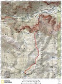
P1はBadger Pass Ski Areaの駐車場。ここから歩き始めます。
1マイルほどGlacier Point Rdを進んだあたりで(P2)左折し、雪原に入ります。新雪の直後で無い限り、まずトレイルが出来上がっています。3マイルほど歩けばDewey Pointに到着(ルートはかなり大まかです)。
Dewey Pointへは#14と#18の二つのルートがあります。上記は#18で、Up-Downが少なく初心者向き。
#14への分岐はP1からの緩やかな坂を上りきったところにあります。
P4はCrocker Point。Dewey Pt.の直前で分岐、10分ほど下れば到着(トレイルが出来ていれば)。
P5: Inspiration Point。Tunnel Viewの山側の駐車場にTHがありそこから1.5マイル弱。
周りは木々に囲まれ、大展望はありません。期待していくとがっかりしますのでご注意。
P6: おそらく誰もが一度は車で行くTunnel View (Discovery View)。一番有名な観光スポットの一つ。
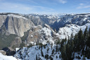
Dewey Pointから見るValley。
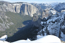
Crocker Pt.から見るValley。Dewey Pt.に比べヨセミテ南東方面の遠望にかけますが、真下にBridalveil Fallを見下ろせ、水量の多いときには展望を楽しめそうな感じ。
【重要】ハーフドーム登頂の事前許可プログラムが試行
NPSは今シーズン(5月〜10月)のハーフドーム登頂は、金曜日、土曜日、日祝日については各400名に制限するようです。(内訳:300名の日帰り、100名のウィルダネス宿泊許可)
3月1日からrecreation.gov もしくはTEL.1-877-444-6777で受付、1予約につき最大4名。手数料$1.5のようです。
今シーズン、ハーフドーム登頂をプランされている方は日程に注意し、必ず事前許可をとってください。
Yosemite National Park Announces Interim Program for Half Dome Day Use Permits to Address Visitor Safety
Half Dome Permits
Frequently Asked Questions about Half Dome Permits